
A glacier is a persistent body of dense ice that is constantly moving under its own weight; it forms where the accumulation of snow exceeds its ablation over many years, often centuries. Glaciers slowly deform and flow due to stresses induced by their weight, creating crevasses, seracs, and other distinguishing features. They also abrade rock and debris from their substrate to create landforms such as cirques and moraines. Glaciers form only on land and are distinct from the much thinner sea ice and lake ice that form on the surface of bodies of water.

A valley is a low area between hills or mountains typically with a river running through it. In geology, a valley or dale is a depression that is longer than it is wide. The terms U-shaped and V-shaped are descriptive terms of geography to characterize the form of valleys. Most valleys belong to one of these two main types or a mixture of them, at least with respect to the cross section of the slopes or hillsides.

A moraine is any glacially formed accumulation of unconsolidated glacial debris that occurs in both currently and formerly glaciated regions on Earth, through geomorphological processes. Moraines are formed from debris previously carried along by a glacier and normally consisting of somewhat rounded particles ranging in size from large boulders to minute glacial flour. Lateral moraines are formed at the side of the ice flow and terminal moraines at the foot, marking the maximum advance of the glacier. Other types of moraine include ground moraines, till-covered areas with irregular topography, and medial moraines which are formed where two glaciers meet.

Glaciology is the scientific study of glaciers, or more generally ice and natural phenomena that involve ice.

The exposed geology of the Yosemite area includes primarily granitic rocks with some older metamorphic rock. The first rocks were laid down in Precambrian times, when the area around Yosemite National Park was on the edge of a very young North American continent. The sediment that formed the area first settled in the waters of a shallow sea, and compressive forces from a subduction zone in the mid-Paleozoic fused the seabed rocks and sediments, appending them to the continent. Heat generated from the subduction created island arcs of volcanoes that were also thrust into the area of the park. In time, the igneous and sedimentary rocks of the area were later heavily metamorphosed.

A pyramidal peak, sometimes called a glacial horn in extreme cases, is an angular, sharply pointed mountain peak which results from the cirque erosion due to multiple glaciers diverging from a central point. Pyramidal peaks are often examples of nunataks.

A cirque is an amphitheatre-like valley formed by glacial erosion. Alternative names for this landform are corrie and cwm. A cirque may also be a similarly shaped landform arising from fluvial erosion.

Glacial motion is the motion of glaciers, which can be likened to rivers of ice. It has played an important role in sculpting many landscapes. Most lakes in the world occupy basins scoured out by glaciers. Glacial motion can be fast or slow, but is typically around 1 metre/day.

Glacial landforms are landforms created by the action of glaciers. Most of today's glacial landforms were created by the movement of large ice sheets during the Quaternary glaciations. Some areas, like Fennoscandia and the southern Andes, have extensive occurrences of glacial landforms; other areas, such as the Sahara, display rare and very old fossil glacial landforms.
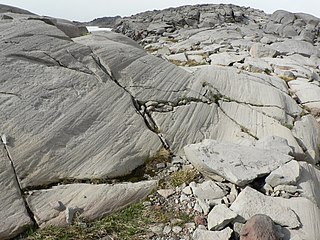
Glacial striations are scratches or gouges cut into bedrock by glacial abrasion. These scratches and gouges were first recognized as the result of a moving glacier in the late 18th century when Swiss alpinists first associated them with moving glaciers. They also noted that if they were visible today that the glaciers must also be receding.

In glaciology, a roche moutonnée is a rock formation created by the passing of a glacier. The passage of glacier ice over underlying bedrock often results in asymmetric erosional forms as a result of abrasion on the "stoss" (upstream) side of the rock and plucking on the "lee" (downstream) side. These erosional features are seen on scales of less than a metre to several hundred metres.
A paternoster lake is one of a series of glacial lakes connected by a single stream or a braided stream system. The name comes from the word Paternoster, another name for the Lord's Prayer derived from the Latin words for the prayer's opening words, "Our Father"; Paternoster lakes are so called because of their resemblance to rosary beads, with alternating prayer beads connected by a string or fine chain.

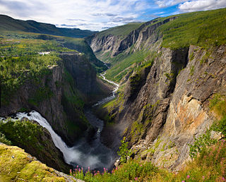
U-shaped valleys, trough valleys or glacial troughs, are formed by the process of glaciation. They are characteristic of mountain glaciation in particular. They have a characteristic U shape, with steep, straight sides and a flat or rounded bottom. Glaciated valleys are formed when a glacier travels across and down a slope, carving the valley by the action of scouring. When the ice recedes or thaws, the valley remains, often littered with small boulders that were transported within the ice, called glacial till or glacial erratic.

Glacier morphology, or the form a glacier takes, is influenced by temperature, precipitation, topography, and other factors. Types of glaciers range from massive ice sheets, such as the Greenland ice sheet or those in Antarctica, to small cirque glaciers perched on a mountain. Glaciers can be grouped into two main categories, based on whether ice flow is constrained by the underlying bedrock topography.

Abrasion is a process of erosion which occurs when material being transported wears away at a surface over time. It is the process of friction caused by scuffing, scratching, wearing down, marring, and rubbing away of materials. The intensity of abrasion depends on the hardness, concentration, velocity and mass of the moving particles. Abrasion generally occurs four ways. Glaciation slowly grinds rocks picked up by ice against rock surfaces. Solid objects transported in river channels make abrasive surface contact with the bed and walls. Objects transported in waves breaking on coastlines cause abrasion. And, finally, abrasion can be caused by wind transporting sand or small stones against surface rocks.

Overdeepening is a characteristic of basins and valleys eroded by glaciers. An overdeepened valley profile is often eroded to depths which are hundreds of metres below the deepest continuous line along a valley or watercourse. This phenomenon is observed under modern day glaciers, in salt-water fjords and fresh-water lakes remaining after glaciers melt, as well as in tunnel valleys which are partially or totally filled with sediment. When the channel produced by a glacier is filled with debris, the subsurface geomorphic structure is found to be erosionally cut into bedrock and subsequently filled by sediments. These overdeepened cuts into bedrock structures can reach a depth of several hundred metres below the valley floor.

The Kankakee Torrent was a catastrophic flood that occurred 19,000 years ago in the Midwestern United States. It resulted from a breach of moraines forming a large glacial lake fed by the melting of the Late Wisconsin Laurentide Ice Sheet. The point of origin of the flood was from Lake Chicago. The landscape south of Chicago still shows the effects of the torrent, particularly at Kankakee River State Park and on the Illinois River at Starved Rock State Park.
A valley step is a prominent change in the longitudinal slope of a valley, mainly in trough valleys formed by glaciers.


