Baffin Bay, located between Baffin Island and the west coast of Greenland, is a marginal sea of the North Atlantic Ocean. It is connected to the Atlantic via Davis Strait and the Labrador Sea. The narrower Nares Strait connects Baffin Bay with the Arctic Ocean. The bay is not navigable most of the year because of the ice cover and high density of floating ice and icebergs in the open areas. However, a polynya of about 80,000 km2 (31,000 sq mi), known as the North Water, opens in summer on the north near Smith Sound. Most of the aquatic life of the bay is concentrated near that region.

Sverdrup Island or Svordrup Island is an isolated island in the southern region of the Kara Sea. This island is covered with tundra vegetation. It is located 120 km north of Dikson on the Siberian coast. The nearest land mass is the Arkticheskiy Institut Islands, about 90 km to the northeast. The island has a wide bay opening towards the west. Its length is 15 km and its maximum width 10 km.

Billefjorden is the central fjord of the three branching from the innermost part of the Isfjorden to the northeast, in Svalbard, Norway. It is 30 km long and 5–8 km wide. Billefjorden lies between Dickson Land to the northwest and Bünsow Land in the southeast. Located on its northwestern shore is the former Russian mining community of Pyramiden. To the northeast is Nordenskiöldbreen.
Adventfjorden is a 7 km long and 4 km wide bay on the southern side of Isfjorden, on the west coast of Spitsbergen. The name is a corruption of Adventure Bay, which was probably named after the Hull whaleship Adventure, which resorted to Isfjorden in 1656. The fjord was originally known as Klass Billen Bay. At the head of Adventfjorden is Adventdalen.
Grønfjorden is a 16 km long fjord, separated from Isfjorden to the north by Festningsodden in the west and Heerodden in the east. It lies within the western portion of Nordenskiöld Land. On its eastern shore is the mining community of Barentsburg, the second largest settlement on Spitsbergen.
Ekmanfjorden is an 18 km (11 mi) long fjord branching north from inner Isfjorden. It is separated by Nordfjorden to the south by Sveaneset in the west and Kapp Wærn in the east. It lies within Nordre Isfjorden National Park.

Łosiewice is a village in the administrative district of Gmina Łochów, within Węgrów County, Masovian Voivodeship, in east-central Poland. It lies approximately 6 kilometres (4 mi) north of Łochów, 28 km (17 mi) north-west of Węgrów, and 65 km (40 mi) north-east of Warsaw.
Strzyżewo Paczkowe is a village in the administrative district of Gmina Gniezno, within Gniezno County, Greater Poland Voivodeship, in west-central Poland. It lies approximately 11 kilometres (7 mi) north-east of Gniezno and 59 km (37 mi) east of the regional capital Poznań.
Siemiany is a village in the administrative district of Gmina Iława, within Iława County, Warmian-Masurian Voivodeship, in northern Poland. It lies approximately 16 kilometres (10 mi) north of Iława and 61 km (38 mi) west of the regional capital Olsztyn.
Jutulstraumen Glacier is a large glacier in Queen Maud Land, Antarctica, about 120 nautical miles (220 km) long, draining northward to the Fimbul Ice Shelf between the Kirwan Escarpment, Borg Massif and Ahlmann Ridge on the west and the Sverdrup Mountains on the east. It was mapped by Norwegian cartographers from surveys and air photos by the Norwegian–British–Swedish Antarctic Expedition (1949–52) and air photos by the Norwegian expedition (1958–59) and named Jutulstraumen. More specifically jutulen are troll-like figures from Norwegian folk tales. The ice stream reaches speeds of around 4 metres per day near the coast where it is heavily crevassed.

The borders of the oceans are the limits of the Earth's oceanic waters. The definition and number of oceans can vary depending on the adopted criteria.
Sabine Land is a land area on the east coast of Spitsbergen, Svalbard. It is named after explorer General Sir Edward Sabine. Among the glaciers in the area is the 250-square-kilometer (97 sq mi) Nordmannsfonna glacier.

Zeppelin Observatory (Zeppelinobservatoriet) is a research station in Svalbard, Norway. It is located near the top of Zeppelinfjellet above Ny-Ålesund on the peninsula of Brøggerhalvøya. It is operated by the Norwegian Polar Institute.
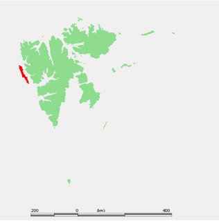
Finneset is a peninsula located on the east side of Grønfjorden on Spitsbergen in Svalbard, Norway. It is located 2 kilometers (1.2 mi) south of Barentsburg. A whaling station was located there until 1905. From 1911 it became the site of the first wireless station in the Arctic, named Svalbard Radio from 19 September 1925. It was also a meteorological station operated by the Norwegian Meteorological Institute. Both services moved to Longyearbyen on 1 September 1930. It is named for being a fine place to land a ship.

Platåberget is a mountain in Nordenskiöld Land on the island of Spitsbergen in Svalbard, Norway. It is 464 meters (1,522 ft) tall and has a distinct plateau shape, for which it is named. It is bordered to the west by Bjørndalen, to the east by Blomsterdalen and to the north by Hotellneset and Adventfjorden. The mountain a few kilometers from Longyearbyen and next to Svalbard Airport, Longyear. It is the site of Svalbard Satellite Station and Svalbard Global Seed Vault.

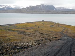
Hiorthhamn is an abandoned settlement located on the east side of Adventfjorden on the island of Spitsbergen in Svalbard, Norway. It served as a coal mining camp from 1917 to 1921 operated by De Norske Kullfelter Spitsbergen. The settlement was named for the company's director, Fredrik Hiorth (1851–1923). Muskox were introduced in the area from Greenland in 1929, and the camp took the name Moskushamn in 1938. It reverted to its original name in 2002.
Kvadehuksletta is a plain located on the outermost part of the peninsula of Brøggerhalvøya on the west coast of the island of Spitsbergen in Svalbard, Norway. It takes its name after Kvadehuken, the outermost part of the peninsula. It is again a Norwegianization of the Dutch "Quade hoek", which means bad corner.
Jerrabattgulla Creek, a perennial stream of the Shoalhaven River catchment, is located in the Southern Tablelands region of New South Wales, Australia.
Svanbergfjellet is a mountain in Olav V Land at Spitsbergen, Svalbard. It has a height of 1,024 m.a.s.l. and is located east of Billefjorden and west of Akademikarbreen. The mountain is named after Swedish astronomer Jöns Svanberg. A point on the mountain was used as a trigonometric point during the Swedish-Russian Arc-of-Meridian Expedition.