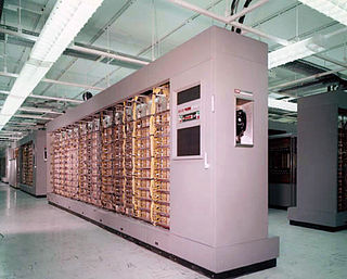
The AN/FSQ-7 Combat Direction Central, referred to as the Q7 for short, was a computerized command and control system for Cold War ground-controlled interception used in the USAF Semi-Automatic Ground Environment (SAGE) air defense network. The largest discrete computer system ever built, each of the 24 installed machines weighed 250 tons. The AN/FSQ-7 used a total of 60,000 vacuum tubes and up to 3 megawatts of electricity, performing about 75,000 instructions per second for networking regional radars.

Naval Tactical Data System, commonly known as NTDS, refers to a computerized information processing system developed by the United States Navy in the 1950s and first deployed in the early 1960s for use in combat ships. It took reports from multiple sensors on different ships and collated it to produce a single unified map of the battlespace. This information could then be relayed back to the ships and to the weapons operators.

Ground Equipment Facility J-33 was a Federal Aviation Administration (FAA) radar station of the Joint Surveillance System's Western Air Defense Sector (WADS) with an Air Route Surveillance Radar (ARSR-4). The facility was previously a USAF general surveillance radar station during the Cold War.

Thomasville Air Force Station is a closed United States Air Force General Surveillance Radar station. It is located 1.9 miles (3.1 km) north-northwest of Thomasville, Alabama. It was closed in 1969.

Ground Equipment Facility QRC is an FAA radar station that was part of a Cold War SAGE radar station for aircraft control and warning "from Massachusetts to southern Virginia, and as far out to sea as possible." Benton AFS was also the first operational "regional data processing center" for the GE 477L Nuclear Detection and Reporting System.

The SAGE radar stations of Air Defense Command were the military installations operated by USAF squadrons using the 1st automated air defense environment and networked by the SAGE System, a computer network. Most of the radar stations used the Burroughs AN/FST-2 Coordinate Data Transmitting Set (CDTS) to automate the operator environment and provide radar tracks to sector command posts at SAGE Direction Centers (DCs), e.g., the Malmstrom Z-124 radar station was co-located with DC-20. The sector/division radar stations were networked by DCs and Manual Control Centers to provide command, control, and coordination for ground-controlled interception of enemy aircraft by interceptors such as the F-106 developed to work with the SAGE System.
Dauphin Island Air Force Station is a closed United States Air Force General Surveillance Radar station. It is located 1.9 miles (3.1 km) east of Dauphin Island, Alabama, near historic Fort Gaines (Alabama). It was closed in 1980.

Eufaula Air Force Station is a closed United States Air Force General Surveillance Radar station. It is located 6.4 miles (10.3 km) west of Eufaula, Alabama. It was closed in 1968.

Havre Air Force Station is a Formerly Used Defense Site that was used as a Cold War general surveillance radar station. In addition to radar facilities and a NORAD Control Center the site had support services: NCO club, bowling alley, hobby shops, library, movie theater, barber shop, exchange, commissary, grade school, and housing for officers and senior NCOs.

Olathe Air Force Station is a former United States Air Force radar station that was located in Gardner, Kansas. It was located next to Naval Air Station Olathe, now the grounds of New Century AirCenter.

Mount Lemmon Air Force Station is a closed United States Air Force General Surveillance Radar station. It is located 17.2 miles (27.7 km) north-northeast of Tucson, Arizona. It was closed in 1969.

Santa Rosa Island Air Force Station is a closed United States Air Force General Surveillance Radar station. It is located 5.6 miles (9.0 km) south-southwest of Lompoc, California. It was closed in 1968 by the Air Force, and turned over to the Federal Aviation Administration (FAA).

Canadian Forces Station Beaverlodge is a closed General Surveillance Radar station. It is located 4.9 miles (7.9 km) east-northeast of Beaverlodge, Alberta. It was closed in 1988.
Backup Interceptor Control was the Electronic Systems Division 416M System to backup the SAGE 416L System in the United States and Canada. BUIC deployed Cold War command, control, and coordination systems to SAGE radar stations to create dispersed NORAD Control Centers.
The Burroughs AN/GSA-51 Radar Course Directing Group was a United States Air Force air defense command, control, and coordination system, part of the Semi-Automatic Ground Environment system. It was intended to replace vacuum tube IBM AN/FSQ-7 Combat Direction Centrals. Developed under Electronic Systems Division's 416M Program, in 1962 Burroughs "won the contract to provide a military version of its D825" modular data processing system for the AN/GSA-51 to be used at "BUIC II radar sites" BUIC II was 1st used at North Truro Z-10 in 1966, and the Hamilton AFB BUIC II was installed in the former MCC building.
A command, control, and coordination system (CCCS) was a Cold War computer system for United States command posts to use a single location to coordinate multiple units' ground-controlled interception and may refer to:
The GE AN/GPA-37 Course Directing Group was a USAF Cold War air defense command, control, and coordination system for weapons direction. During Air Defense Command's "Control Capability Improvement Program" to improve command guidance of manned aircraft, the AN/GPA-37 was "developed by the General Electric Heavy Military Electronic Equipment Department at Syracuse in conjunction with...Rome Air Development Center and the Electronics Research Laboratories of Columbia University." Used to process radar data, the system was to "track a potential enemy aircraft and direct intercepters [sic] into a position from which they can make their automatic firing runs", the system included the:
An Air Defense Direction Center (ADDC) was a type of United States command post for assessing Cold War radar tracks, assigning height requests to available height-finder radars, and for "Weapons Direction": coordinating command guidance of aircraft from more than 1 site for ground-controlled interception. As with the World War II Aircraft Warning Service CONUS defense network, a "manual air defense system" was used through the 1950s Along with 182 radar stations at "the end of 1957, ADC operated … 17 control centers", and the Ground Observation Corps was TBD on TBD. With the formation of NORAD, several types of ADDCs were planned by Air Defense Command:
The Experimental Semi-Automatic Ground Environment (SAGE) Sector was a prototype Cold War Air Defense Sector for developing the Semi Automatic Ground Environment. The Lincoln Laboratory control center in a new building was at Lexington, Massachusetts.


