See also
| This disambiguation page lists articles associated with the title CSCS. If an internal link led you here, you may wish to change the link to point directly to the intended article. |
CSCS may refer to:
| This disambiguation page lists articles associated with the title CSCS. If an internal link led you here, you may wish to change the link to point directly to the intended article. |

Colorado Springs is a home rule municipality that is the largest city by area in Colorado as well as the county seat and the most populous municipality of El Paso County, Colorado, United States. Colorado Springs is located in the east central portion of the state. It is situated on Fountain Creek and is located 60 miles (97 km) south of the Colorado State Capitol, Denver.
The Western Slope of Colorado refers to a region of the U.S. state of Colorado incorporating everything in the state west of the Continental Divide, including Moffat, Routt, Hinsdale, Grand, Summit, LaPlata, Montezuma, Dolores, Eagle, Pitkin, Rio Blanco, Garfield, Mesa, Delta, Montrose, Gunnison, Ouray, and San Miguel counties and portions of Saguache, Archuleta, Mineral, and San Juan counties. The Colorado River and its tributaries divide the region into north and south at Grand Junction, Colorado. The area has a climate similar to that of the Great Basin.

The Congregation of Holy Cross or Congregatio a Sancta Cruce (C.S.C.) is a Catholic congregation of missionary priests and brothers founded in 1837 by Blessed Basil Moreau, in Le Mans, France.

The University of Colorado Colorado Springs (UCCS) is a public research university in Colorado Springs, Colorado. It is one of the 4 campuses of the University of Colorado system. As of Fall 2017, UCCS had over 12,400 undergraduate and 1,822 graduate students, with 32% ethnic minority students.

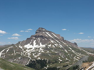
Uncompahgre Peak is the sixth highest summit of the Rocky Mountains of North America and the U.S. state of Colorado. The prominent 14,321-foot (4365.0 m) fourteener is the highest summit of the San Juan Mountains and the highest point in the drainage basin of the Colorado River and the Gulf of California. It is located in the Uncompahgre Wilderness in the northern San Juans, in northern Hinsdale County approximately 7 miles (11 km) west of the town of Lake City.

The Spanish Peaks are a pair of prominent mountains located in southwestern Huerfano County, Colorado. The Ute Indians named them Huajatolla meaning "two breasts" or "breasts of the Earth".

Storm King Mountain is a mountain in the White River National Forest of the Rocky Mountains, 5 miles (8.0 km) northwest of Glenwood Springs, Colorado, in northeastern Garfield County. It is on the north side of the Colorado River and Interstate 70 (I-70), between Glenwood Springs and New Castle.A ski lift at the Copper Mountain Ski Resort is named after the mountain.

U.S. Route 40 (US 40) is a part of the U.S. Highway System that travels from Silver Summit, Utah, to Atlantic City, New Jersey. In the U.S. state of Colorado, US 40 is a major east–west route. It crosses the Rocky Mountains, passing over the Continental Divide at Berthoud Pass before descending to the front range. It then traverses through the Denver Metro Area, then exits by following Interstate 70 (I-70) and US 287. It is concurrent with US 287 for about 145 miles to Kit Carson. US 40 exits into Kansas east of Arapahoe in Cheyenne. At a length of almost 500 miles, US 40 is the longest numbered route in the state.

Sports in Colorado include professional teams, college sports, and individual sports.

The following outline is provided as an overview of and topical guide to the U.S. state of Colorado:

Pikes Peak is the highest summit of the southern Front Range of the Rocky Mountains, in North America. The ultra-prominent 14,115-foot (4,302.31 m) fourteener is located in Pike National Forest, 12 miles (19 km) west of downtown Colorado Springs, Colorado. The mountain is named in honor of American explorer Zebulon Pike. The summit is higher than any point in the United States east of its longitude.

Mount Rosa is a mountain summit of the Pikes Peak Massif in the southern Front Range of the Rocky Mountains of North America. The 11,504-foot (3,506 m) peak is located in Pike National Forest, 12.8 miles (20.6 km) southwest by west of downtown Colorado Springs in Teller County, Colorado, United States.

The Manitou Springs Incline, also known as the Manitou Incline or simply the Incline, is a popular hiking trail rising above Manitou Springs, Colorado, near Colorado Springs. The trail is the remains of a former 3 ft narrow gauge funicular railway whose tracks washed out during a rock slide in 1990. The Incline is famous for its sweeping views and steep grade, with an average grade of 45% (24°) and as steep as 68% (34°) in places, making it a fitness challenge for locals of the Colorado Springs area. The incline gains 2,011 feet (613 m) of elevation in .88 miles (1.42 km) horizontal. Currently the Incline has approximately 2,744 steps from the bottom to the summit, although the top step is numbered "2768". The number of steps changes occasionally with trail maintenance and deterioration.

Blair Mountain is the highest summit of the White River Plateau in the Rocky Mountains of North America. The prominent 11,465-foot (3,495 m) peak is located in White River National Forest, 17.5 miles (28.2 km) north by west of the City of Glenwood Springs in Garfield County, Colorado, United States.

Horse Mountain is a prominent mountain summit in the San Juan Mountains range of the Rocky Mountains of North America. The 9,952-foot (3,033 m) peak is located in San Juan National Forest, 15.8 miles (25.5 km) west by north of the Town of Pagosa Springs in Archuleta County, Colorado, United States.

Blodgett Peak is a mountain summit in El Paso County, Colorado. Blodgett Peak is located in Pike National Forest. and at its base is Blodgett Peak Open Space of Colorado Springs.

Cheyenne Mountain is a triple-peaked mountain in El Paso County, Colorado, southwest of downtown Colorado Springs. The mountain serves as a host for military, communications, recreational, and residential functions. The underground operations center for the North American Aerospace Defense Command (NORAD) was built during the Cold War to monitor North American airspace for missile launches and Soviet military aircraft. Built deep within granite, it was designed to withstand bombing and fallout from a nuclear bomb. Its function broadened with the end of the Cold War, and then many of its functions were transferred to Peterson Air Force Base in 2006.
The Green Party of Colorado (GPCO) is the affiliate of the Green Party of the United States for the state of Colorado.

Elk Mountain is a summit in Routt County, Colorado. The mountain lies to the northwest of Steamboat Springs and is easily seen from the city, especially from along Lincoln Avenue, Steamboat's main street. The mountain is also easily seen from Mount Werner, the home of the Steamboat Ski Resort.