Portland is the largest and most populous city in the U.S. state of Oregon and the seat of Multnomah County. It is a major port in the Willamette Valley region of the Pacific Northwest, at the confluence of the Willamette and Columbia rivers. As of 2017, Portland had an estimated population of 647,805, making it the 26th-largest city in the United States, and the second-most populous in the Pacific Northwest. Approximately 2.4 million people live in the Portland metropolitan statistical area (MSA), making it the 25th most populous MSA in the United States. Its Combined Statistical Area (CSA) ranks 18th-largest with a population of around 3.2 million. Approximately 60% of Oregon's population resides within the Portland metropolitan area.

Oregon City is the county seat of Clackamas County, Oregon, United States, located on the Willamette River near the southern limits of the Portland metropolitan area. Established in 1829 by the Hudson's Bay Company, in 1844 it became the first U.S. city west of the Rocky Mountains to be incorporated.

Torrance is a U.S. city in the South Bay (southwestern) region of Los Angeles County, California in the Los Angeles metropolitan area. Torrance has 1.5 miles (2.4 km) of beaches on the Pacific Ocean. Torrance has a moderate year-round climate with warm temperatures, sea breezes, low humidity, and an average rainfall of 12.55 inches per year.

Forest Park is a public municipal park in the Tualatin Mountains west of downtown Portland, Oregon, United States. Stretching for more than 8 miles (13 km) on hillsides overlooking the Willamette River, it is one of the country's largest urban forest reserves. The park, a major component of a regional system of parks and trails, covers more than 5,100 acres (2,064 ha) of mostly second-growth forest with a few patches of old growth. About 70 miles (110 km) of recreational trails, including the Wildwood Trail segment of the city's 40-Mile Loop system, crisscross the park.

Ladd's Addition is an inner southeast historic district of Portland, Oregon, United States. It is Portland's oldest planned residential development, and one of the oldest in the western United States. The district is known in Portland for a diagonal street pattern, which is at odds with the rectilinear grid of the surrounding area. Roughly eight blocks (east-west) by ten blocks (north-south) in size, Ladd's is bordered by SE Hawthorne, Division, 12th, and 20th streets. It is part of the Hosford-Abernethy neighborhood association.

St. Johns is a neighborhood of Portland, Oregon, United States, located in North Portland on the tip of the peninsula formed by the confluence of the Willamette River and the Columbia River. It was a separate, incorporated city from 1902 until 1915, when citizens of both St. Johns and Portland voted to approve its annexation to Portland, which took effect on July 8, 1915.

Kenton is a neighborhood in the north section of Portland, Oregon, United States. The neighborhood was originally a company town founded in 1911 for the Swift Meat Packing Company.
Linnton is a Portland, Oregon neighborhood located between Forest Park and the Willamette River along U.S. Route 30, close to the agricultural community of Sauvie Island. It borders the neighborhoods of Northwest Industrial on the south, St. Johns and Cathedral Park via the St. Johns Bridge across the Willamette on the east, and Forest Park on the west. The neighborhood extends north somewhat beyond Portland city limits into unincorporated Multnomah County, ending at the Sauvie Island Bridge.
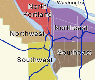
There are five sections of Portland, Oregon, though a sixth is planned, and 95 officially recognized neighborhoods, each of which is represented by a volunteer-based neighborhood association. These associations serve as the liaison between residents and the city government, as coordinated by the city's Office of Community & Civic Life, which was created in 1974 and known as the Office of Neighborhood Involvement until July 2018. The city subsequently provides funding to this "network of neighborhoods" through district coalitions, which are groupings of neighborhood associations. On June 6, 2018, Portland City Council voted to add a sixth section to Portland; it will be called South Portland and the transition to the new system is expected to start in May 2020.
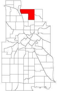
Wilkes is the northeastern most neighborhood in Portland, Oregon, bordered on the north by the Columbia River and on the east by the city of Gresham. It adjoins the neighborhoods of Argay, Russell, and Hazelwood on the west, and Glenfair on the south. Interstate 84 runs through the middle of the neighborhood.

Rose City Park is a neighborhood in Northeast Portland, Oregon. It borders Beaumont-Wilshire, Grant Park, and the Hollywood District on the west, Cully on the north, Roseway and Madison South on the east, and Center on the south.
Piedmont is a neighborhood in the north and northeast sections of Portland, Oregon. The Piedmont subdivision was platted in 1889 by Edward Quackenbush, and promoted in an early flyer as "The Emerald, Portland's Evergreen Suburb, Devoted Exclusively to Dwellings, A Place of Homes." The original subdivision, now known as "Historic Piedmont," includes parts of the Humboldt and King neighborhoods, as well as the modern Piedmont neighborhood south of Rosa Parks Way.
University Park is a neighborhood in the north section of Portland, Oregon on the east shore of the Willamette River. University Park is bounded by North Lombard Street and the Portsmouth neighborhood to the north, North Chautauqua Boulevard and the Arbor Lodge neighborhood to the east, The Willamette River and Mock's Bottom industrial area to the south, and the North Portland railroad cut with Cathedral Park and St. Johns neighborhoods to the west.

Downtown East is an official neighborhood in Minneapolis, Minnesota, United States part of the larger Central community. Its boundaries are the Mississippi River to the north, Interstate 35W to the east, 5th Street South to the south, and Portland Avenue to the west. It is bounded by the Downtown West, Elliot Park, and Cedar-Riverside neighborhoods. The Marcy-Holmes neighborhood is on the other side of the river, but there is no direct automobile connection between the two neighborhoods. There is a pedestrian and bicycle connection via the Stone Arch Bridge. Downtown East was home to the Hubert H. Humphrey Metrodome, where the Minnesota Twins, Minnesota Vikings, and Minnesota Gophers have all played home games. As of 2009, the Minnesota Golden Gophers moved into the new TCF Bank Stadium on the University of Minnesota Campus. Additionally, the Minnesota Twins moved into new Target Field at the start of the 2010 season. In 2016, U.S. Bank Stadium opened on the Metrodome's former site.

The Mt. Scott-Arleta neighborhood of Portland, Oregon is located in the city's southeast quadrant. It is bounded on the north by SE Foster Road, west by SE 60th Avenue, east by SE 82nd Avenue, and south by SE Duke. Mt. Scott-Arleta borders the neighborhoods of Woodstock on the west, Foster-Powell on the north, Lents on the east, and Brentwood-Darlington on the south.

Columbia Park is a 52-acre (21 ha) recreational urban regional park in the City of Torrance, located in southern Los Angeles County, California. Columbia Park provides the community with soccer fields, baseball diamonds, bocce ball courts, community gardening beds, walking paths, and a jogging—competitive cross country running trail. It is one of thirty parks in the Torrance Parks system.

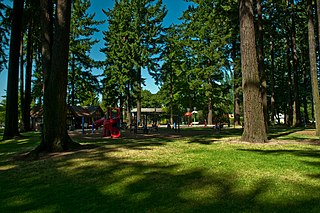
Irving Park is a city park of about 16 acres (6.5 ha) in northeast Portland, in the U.S. state of Oregon. Located at Northeast 7th Avenue and Fremont Street in the Irvington neighborhood, the park is on land that was originally owned by William Irving, for whom the neighborhood was named. The Irvington Racetrack once occupied part of the land.

Francis I. McKenna was a real estate and land developer, and architect from the 1890s to the 1920s in Portland, Oregon. McKenna moved to Portland in 1889 and purchased the land now known as the University Park neighborhood. He went on to establish the Portland Belt Line Company, which lobbied city officials to extend the cable car system to St. Johns, Oregon. The project was constructed in 1905. McKenna was also known as an advocate of civic improvement and industrialization.
Charles B. Walker Stadium at Lents Park is a baseball stadium located in Lents Park in the Lents neighborhood of Portland, Oregon. It has been home to the West Coast League Portland Pickles baseball team since 2016. The Pickles play thirty home games per sixty game season. The team pays rent to the City, cleans the stadium, and provides security during games. Outside of the dates set aside for the team, the stadium is open for permitted play by anyone who reserves it. The Northwest Independent Baseball League plays many of its games at Walker Stadium.