
Pacific Beach is a neighborhood in San Diego, bounded by La Jolla to the north, Mission Beach and Mission Bay to the south, Interstate 5 to the east and the Pacific Ocean to the west. While formerly largely populated by young people, surfers, and college students, because of rising property and rental costs the population is gradually becoming older and more affluent. "P.B.," as it is known as by local residents, is home to one of San Diego's more developed nightlife scenes, with a great variety of bars, eateries, and clothing stores located along Garnet Avenue and Mission Boulevard.

The San Diego Zoo Safari Park, originally named the San Diego Wild Animal Park until 2010, is an 1,800 acre zoo in the San Pasqual Valley area of San Diego, California, near Escondido. It is one of the largest tourist attractions in San Diego County. The park houses a large array of wild and endangered animals including species from the continents of Africa, Asia, Europe, North and South America, and Australia. The park is in a semi-arid environment, and one of its most notable features is the Africa Tram, which explores the expansive African exhibits. These free-range enclosures house such animals as antelopes, giraffes, buffalo, cranes, and rhinoceros. The park is also noted for its California condor breeding program, the most successful such program in the United States.

Flinders Chase National Park is a protected area in the Australian state of South Australia located at the west end of Kangaroo Island about 177 kilometres west-south west of the state capital of Adelaide and 110 kilometres west of the municipal seat of Kingscote. It is a sanctuary for endangered species and home to a few geological phenomena. It was the second national park to be declared in South Australia.

Livingston Island is an Antarctic island in the South Shetland Islands, Western Antarctica lying between the islands of Greenwich and Snow. It was the first land discovered south of 60° south latitude in 1819, a historic event that marked the end of a centuries-long pursuit of the mythical Terra Australis Incognita and the beginning of the exploration and utilization of real Antarctica. The name Livingston, although of unknown derivation, has been well established in international usage since the early 1820s.

The San Diego River is a river in San Diego County, California. It originates in the Cuyamaca Mountains northwest of the town of Julian, then flows to the southwest until it reaches the El Capitan Reservoir, the largest reservoir in the river's watershed at 112,800 acre feet (139,100,000 m3). Below El Capitan Dam, the river runs west through Santee and San Diego. While passing through Tierrasanta it goes through Mission Trails Regional Park, one of the largest urban parks in America. The river discharges into the Pacific Ocean near the entrance to Mission Bay, forming an estuary.
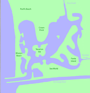
Mission Bay is a saltwater bay or lagoon located south of the Pacific Beach community of San Diego, California. The bay is part of the recreational Mission Bay Park, the largest man-made aquatic park in the country, consisting of 4,235 acres (17.14 km2), approximately 46% land and 54% water. The combined area makes Mission Bay Park the ninth largest municipally-owned park in the United States.

Cape Shirreff is a prominent cape at the north end of the rocky peninsula which separates Hero Bay and Barclay Bay on the north coast of Livingston Island, in the South Shetland Islands of Antarctica. The cape was named by Edward Bransfield in 1820 after Captain William H. Shirreff, the British commanding officer in the Pacific at that time.

Mount Friesland is a mountain rising to 1,700.2 metres (5,578 ft) in the homonymous Friesland Ridge, the summit of Tangra Mountains and Livingston Island in the South Shetland Islands, Antarctica. Its north rib is connected to Pliska Ridge by Nesebar Gap on the west, and to Bowles Ridge by Wörner Gap on the north. On the east Mount Friesland is connected to Presian Ridge and further on to Catalunyan Saddle and Lyaskovets Peak. On the south-southwest it is connected by a short saddle to ‘The Synagogue’ a sharp-peaked rock-cored ice formation abutting neighbouring St. Boris Peak. The peak is heavily glaciated and crevassed, surmounting Huntress Glacier to the west, Perunika Glacier to the north-northwest, Huron Glacier to the northeast and Macy Glacier to the southeast. The local weather is notoriously unpleasant and challenging; according to the seasoned Antarctic mountaineer Damien Gildea who climbed in the area, 'just about the worst weather in the world'.

Nepean Bay Conservation Park is a protected area in the Australian state of South Australia on Kangaroo Island. It was dedicated in 1974 for the protection of flora and fauna, and is the only reserved area of coastal sandplain on the island.

Vivonne Bay Conservation Park, formerly the Vivonne Bay National Park, is a protected area in the Australian state of South Australia located on the south coast of Kangaroo Island in the gazetted locality of
Vivonne Bay. It was dedicated in 1971 to conserve coastal country containing vegetation not already protected in Kelly Hill Conservation Park.
Pigface Island Conservation Park is a protected area in the Australian state of South Australia associated with Pigface Island located in Streaky Bay on the west coast of Eyre Peninsula about 13 kilometres north north-east west of the town of Streaky Bay.
Karatta is a locality in the Australian state of South Australia located on the south coast of Kangaroo Island overlooking the body of water known in Australia as the Southern Ocean and by international authorities as the Great Australian Bight. Karatta is located about 191 kilometres south-west of the state capital of Adelaide.

County of Carnarvon is a cadastral unit located in the Australian state of South Australia which covers the full extent of Kangaroo Island. It was proclaimed in 1874 by Governor Musgrave in response to the demand for agriculture land on Kangaroo Island.
D’Estrees Bay is a locality in the Australian state of South Australia located on the south coast of Kangaroo Island overlooking the body of water known in Australia as the Southern Ocean and by international authorities as the Great Australian Bight. It is located about 145 kilometres southwest of the state capital of Adelaide and about 32 kilometres south of the municipal seat of Kingscote.

MacGillivray is a locality in the Australian state of South Australia located on the south coast of Kangaroo Island overlooking the body of water known in Australia as the Southern Ocean and by international authorities as the Great Australian Bight. It is located about 140 kilometres southwest of the state capital of Adelaide and about 24 kilometres south of the municipal seat of Kingscote.

Seal Bay is a locality in the Australian state of South Australia located on the south coast of Kangaroo Island overlooking the body of water known in Australia as the Southern Ocean and by international authorities as the Great Australian Bight. It is located about 164 kilometres southwest of the state capital of Adelaide and about 50 kilometres south of the municipal seat of Kingscote.
Vivonne Bay is a locality in the Australian state of South Australia located on the south coast of Kangaroo Island overlooking the body of water known in Australia as the Southern Ocean and by international authorities as the Great Australian Bight and which includes the bay known as Vivonne Bay. It is located about 174 kilometres southwest of the state capital of Adelaide and about 55 kilometres southwest of the municipal seat of Kingscote.

Seal Bay is a bay in the Australian state of South Australia located on the south coast of Kangaroo Island about 164 kilometres southwest of the state capital of Adelaide and about 50 kilometres south of the municipal seat of Kingscote.

