The Great River Road is a collection of state and local roads that follow the course of the Mississippi River through ten states of the United States. They are Minnesota, Wisconsin, Iowa, Illinois, Missouri, Kentucky, Tennessee, Arkansas, Mississippi and Louisiana. It formerly extended north into Canada, serving the provinces of Ontario and Manitoba.

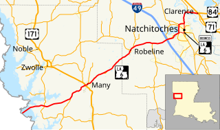
Clarence is a village in Natchitoches Parish, Louisiana, United States. The population was 499 at the 2010 census. It is located some seven miles east of the parish seat of Natchitoches and is part of the Natchitoches Micropolitan Statistical Area.

U.S. Route 61 (US 61) is the official designation for a major United States highway which extends 1,400 miles (2,300 km) between New Orleans, Louisiana and the city of Wyoming, Minnesota. The highway generally follows the course of the Mississippi River, and is designated the Great River Road for much of its route. As of 2004, the highway's northern terminus in Wyoming, Minnesota, is at an intersection with Interstate 35 (I-35). Until 1991, the highway extended north on what is now Minnesota State Highway 61 through Duluth and across the Canada–U.S. border, near Grand Portage. Its southern terminus in New Orleans, Louisiana, is at an intersection with Tulane Avenue at South Broad Street. The highway is often called the Blues Highway because it connects Saint Paul, Minnesota; St. Louis, Missouri; Memphis, Tennessee; the Mississippi Delta, and New Orleans.

El Camino Real, sometimes associated with Calle Real, usually refers to the 600-mile (965-kilometer) road connecting the 21 Spanish missions in California, along with a number of sub-missions, four presidios, and three pueblos, stretching at its southern end from the San Diego area Mission San Diego de Alcalá, all of the way up to the trail's northern terminus at Mission San Francisco Solano in Sonoma, just above San Francisco Bay.

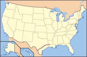
U.S. Route 84 is an east–west U.S. Highway. It started as a short Georgia–Alabama route in the original 1926 scheme, but by 1941 it had been extended all the way to Colorado. The highway's eastern terminus is a short distance east of Midway, Georgia, at an interchange with Interstate 95. The road continues toward the nearby Atlantic Ocean as a county road. Its western terminus is in Pagosa Springs, Colorado, at an intersection with U.S. 160.
U.S. Highway 171 (US 171) is a part of the United States Numbered Highway System and the only route within that system currently located entirely within the state of Louisiana. It spans 177.44 miles (285.56 km) in a north–south direction from the junction of US 90 and Louisiana Highway 14 (LA 14) in Lake Charles to the junction of US 79/US 80 and LA 3094 in Shreveport.

State Route 82 is a state highway in the U.S. state of California that runs from Interstate 880 (I-880) in San Jose to I-280 in San Francisco following the San Francisco Peninsula. It is the spinal arterial road of the peninsula and runs parallel to the nearby Caltrain line along much of the route. For much of its length, the highway is named El Camino Real and formed part of the historic El Camino Real mission trail. It passes through and near many the historic downtowns of many Peninsula cities, including Burlingame, San Mateo, Redwood City, Menlo Park, Palo Alto, Mountain View, and Sunnyvale, and through some of the most walkable and transit-oriented neighborhoods in the region.
There are many historic trails and roads in the United States which were important to the settlement and development of the United States including those used by American Indians.

State Route 123 is a state highway in the U.S. state of California in the San Francisco Bay Area. Named San Pablo Avenue for virtually its entire length, SR 123 is a major north–south state highway along the flats of the urban East Bay in the U.S. state of California. Route 123 runs a relatively short 7.39 miles (11.9 km) between Interstate 580 in the south and Interstate 80 in the north. San Pablo Avenue itself, a portion of Historic US 40, continues well past these termini but without the Route 123 designation.

State Route 72 is a state highway in the U.S. state of California. The route runs along Whittier Boulevard from I-605 in Whittier to SR-39 in La Habra. SR 72 forms part of El Camino Real.

The Camino Real de Tierra Adentro was a 2560 kilometer long trade route between Mexico City and San Juan Pueblo, New Mexico, from 1598 to 1882.
Louisiana Highway 8 is a state highway in Louisiana. It spans 156 miles (251 km) beginning at the Louisiana/Texas state line west of Leesville and ending at an intersection with U.S. Route 425 and LA 15 in Sicily Island.
Farm to Market Road 270, or FM 270 is a state highway in the U.S. state of Texas located inside the Houston–Sugar Land–Baytown metropolitan area. Locally, the road is known as Egret Bay Boulevard.
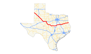
U.S. Route 84 is a U.S. highway that runs from Pagosa Springs, CO to Midway, GA. In Texas, the highway enters the state from New Mexico at Farwell, near the Panhandle region. Major cities along the highway include Lubbock, Abilene, Waco and Palestine. The highway exits Texas into Louisiana near Joaquin, crossing the Toledo Bend Reservoir.
The El Camino Real de los Tejas National Historic Trail is a National Historic Trail covering the U.S. section of the El Camino Real de Los Tejas, a thoroughfare from the 18th-century Spanish colonial era in Spanish Texas instrumental in the settlement, development and history of Texas. The National Park Service designated the El Camino Real de los Tejas National Historic Trail as a unit in the National Historic Trail system in 2004.
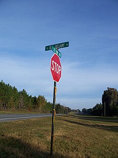
The Bellamy Road was the first major U.S. federal highway in early territorial Florida.
There are 21 routes assigned to the "G" zone of the California Route Marker Program, which designates county routes in California. The "G" zone includes county highways in Monterey, San Benito, San Luis Obispo, Santa Clara, and Santa Cruz counties.
A total of seven special routes of U.S. Route 80 exist or did exist in the past.