
Papua is the largest and easternmost province of Indonesia, comprising most of Western New Guinea. It is bordered by the nation of Papua New Guinea to the east, the province of West Papua to the west, the Pacific Ocean to the north, and the Arafura Sea to the south. According to the 2010 census by Statistics Indonesia, Papua had a population of 2,833,381, majority of whom are Christians. The province is divided into twenty-eight regencies and one city. Its capital and largest city is Jayapura.

The Khabur River is the largest perennial tributary to the Euphrates in Syrian territory. Although the Khabur originates in Turkey, the karstic springs around Ra's al-'Ayn are the river's main source of water. Several important wadis join the Khabur north of Al-Hasakah, together creating what is known as the Khabur Triangle, or Upper Khabur area. From north to south, annual rainfall in the Khabur basin decreases from over 400 mm to less than 200 mm, making the river a vital water source for agriculture throughout history. The Khabur joins the Euphrates near the town of Busayrah.

West Papua is a province of Indonesia. It covers the two western peninsulas of the island of New Guinea along with nearby islands. The province is bordered to the north by the Pacific Ocean, to the west by the Halmahera Sea and the Ceram Sea, to the south by the Banda Sea, and to the east by the province of Papua and the Cenderawasih Bay. Manokwari is the capital, while Sorong is the largest city and the main gateway to the province. According to the 2010 census by Statistics Indonesia, West Papua recorded a population of 760,422. Inaugurated as a province in 2003, West Papua was initially named West Irian Jaya until 2007. The name West Papua itself is also used by the Free Papua Movement to refer the whole Western New Guinea. Consisting of twelve regencies and one city, the province enjoys a special autonomous status as granted by the Indonesian legislation. West Papua is well known by its Raja Ampat Islands which contains the richest marine biodiversity in the world.

The East Geelvink Bay or East Cenderawasih languages are a language family of a dozen Papuan languages along the eastern coast of Geelvink Bay in Indonesian Papua, which is also known as Sarera Bay or Cenderawasih.
The Thames River is located in southwestern Ontario, Canada.

The Bird's Head Peninsula or Doberai Peninsula is a large peninsula that makes up the northwest portion of the island of New Guinea and the major part of the Province of West Papua, Indonesia. The other edge is on the Bird's Tail Peninsula.

The Arfak Mountains is a mountain range found on the Bird's Head Peninsula in the Province of West Papua, Indonesia.
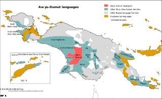
The Greater Awyu languages, known in earlier and more limited classifications as Awyu–Dumut or Awyu–Ndumut, and also known by the geographical label of Digul River languages, are a family of perhaps a dozen Trans–New Guinea languages spoken in eastern West Papua. Six of the languages are sufficiently attested for a basic description; it is not clear how many of the additional names may be separate languages.

New Guinea is a large island separated by a shallow sea from the rest of the Australian continent. It is the world's third-largest island, after Australia and Greenland, covering a land area of 785,753 km2 (303,381 sq mi), and arguably the largest wholly or partly within the Southern Hemisphere and Oceania.
The Ramu languages are a family of some thirty languages of northern Papua New Guinea. They were identified as a family by John Z'graggen in 1971, and linked with the Sepik languages by Donald Laycock two years later. Malcolm Ross (2005) classifies them as one branch of a Ramu – Lower Sepik language family. Z'graggen had included the Yuat languages, but that now seems doubtful.

The Yam languages, also known as the Morehead and Upper Maro River languages, are a family of Papuan languages. They include many of the languages south and west of the Fly River in Papua New Guinea and Indonesian West Papua.

Saukorem is a coastal village in West Papua, Indonesia, located about 125 km (75 mi) north-northwest of Manokwari. The town is located on the northern coast of the Bird's Head Peninsula and administratively it is the principal settlement of Amberbaken subdistrict of the Manokwari Regency.
Koor or Kwoor is a village in West Papua, Indonesia. The village is located in Tambrauw (Regency) on the northern coast of the Bird's Head Peninsula. As of 1994 it was reported to have a population of 589 people.
Mpur, is a language isolate spoken in parts of the Bird's Head Peninsula of New Guinea. It is not closely related to any other language, and though Ross (2005) tentatively assigned it to the West Papuan languages, based on similarities in pronouns, Ethnologue and Glottolog list it as a language isolate. Mpur has a complex tonal system with 4 lexical tones and an additional contour tone, a compound of two of the lexicals. Its tonal system is somewhat similar to the nearby Austronesian languages of Mor and Ma'ya.

The Tamrau Mountains, also known as the Tambrauw Mountains or the Tamarau Mountains, is a mountain range located in the north central region of the Bird's Head Peninsula in the province of West Papua. It is made up of an isolated and lesser continuous mountain chain compared to the Arfak Mountains. The Tamrau and Arfak Mountains are both divided by the grassy Kebar Valley, which is the heartland of many indigenous people, with a variety of backgrounds. The Tamrau Mountains have been very scantily surveyed for any purpose till this day. The mountains are an important and threatened site of biodiversity, part of the Vogelkop Montane Rain Forests Ecoregion.

Bon Irau, with an elevation of 2,501 metres (8,205 ft), is the highest peak in the Tamrau Mountains and the highest point in the province of West Papua outside of the Arfak Mountains. It is located in the north central region of the Bird's Head Peninsula and located around 20 kilometres (12 mi) from the grassy Kebar Valley.

