
The Gulf of Bothnia is the northernmost arm of the Baltic Sea. It is situated between Finland's west coast and Sweden's east coast. In the south of the gulf lie the Åland Islands, between the Sea of Åland and the Archipelago Sea.
Vyborg Bay is a deep inlet running northeastward near the eastern end of Gulf of Finland in the Baltic Sea. The city of Vyborg is located near the head of the gulf.

Lumparn is a large bay devoid of islands in the main island of Åland, Finland, bordered by Sund to the north, Lumparland to the east, Lemland to the south and Jomala to the west.

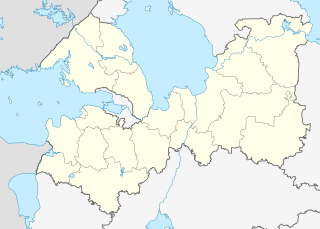
Kymenlaakso is a region in Finland. It borders the regions of Uusimaa, Päijänne Tavastia (Päijät-Häme), Southern Savonia (Etelä-Savo) and South Karelia and Russia. Its name means literally The Valley of River Kymijoki. Kymijoki is one of the biggest rivers in Finland with a drainage basin with 11% of the area of Finland. The city of Kotka with 55,000 inhabitants is located at the delta of River Kymijoki and has the most important import harbour in Finland. Other cities are Kouvola further in the inland which has after a municipal merger 88,000 inhabitants and the old bastion town Hamina.

The Saimaa Canal is a transportation canal that connects lake Saimaa with the Gulf of Finland near Vyborg, Russia. The canal was built from 1845 to 1856 and opened on 7 September 1856 .
It was overhauled and widened in 1963–1968.

Fada N'Gourma, also written Fada-Ngourma, or Noungu is a city and an important market town in eastern Burkina Faso, lying 219 kilometres (136 mi) east of Ouagadougou, in the Gourmantché area. It is the capital of the East region and of Gourma province. It is known for its blanket and carpet manufacturing as well as its honey.

Meilahti is a neighbourhood of Helsinki between Mannerheimintie and a bay named Seurasaarenselkä. Most of the houses in Meilahti were built in the 1930s and 1940s. Meilahti is home to over 6700 people. Meilahti is the location of Mäntyniemi, official residence of the President of Finland, as well as Kesäranta, the official residence of Prime Minister of Finland. Near Mäntyniemi is the former presidential residence, Tamminiemi, which is today a museum dedicated to president Urho Kekkonen.

The Republic of North Ingria, or Republic of Kirjasalo, was a short-lived, small state for the Ingrian Finns in the southern part of the Karelian Isthmus, which seceded from Bolshevist Russia after the October Revolution. Its aim by most proponents was to ultimately be incorporated into the Kingdom of Finland, and it ruled parts of Northern Ingria from 1919 until 1920. With the Peace Treaty of Tartu, it was re-integrated into Russia; however, Ingrian Finns of this area enjoyed a certain degree of national autonomy until the 1930s in compliance with the policy of national delimitation in the Soviet Union. In 1928 the Kuivaisi National District was established there with its administrative base in Toksovo. In 1939 it was abolished and the area was joined to the Pargolovo district. Today, it is the north-eastern part of Vsevolozhsky District.
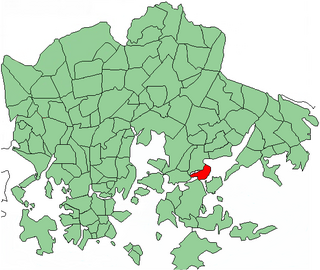
Tammisalo is a neighbourhood and an island in eastern part of Helsinki, Finland. The population of Tammisalo is approximately 2,200 and its area is 0.73 square kilometres. The nearest districts are Herttoniemi, Roihuvuori and Laajasalo. In the Viking era the coastal waterway from Sweden to Arab world went between Tammisalo and the continent along Porolahti bay.
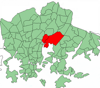
Viikki is a neighbourhood of about 5,500 inhabitants in Helsinki, Finland. It is located at the bottom of Vanhankaupunginlahti bay, some 7–10 km from the city centre.

Vanhakaupunki is a neighbourhood of the city of Helsinki, Finland, to the north of Toukola. It is also the name of a district of the city, which contains the neighbourhood and its surroundings. The name comes from the fact that Helsinki was originally founded in the Vanhakaupunki area. The Swedish name Gamla Helsingfors appears in the new Helsinki foundation document from 1639, as the city was moved to its later location, and the forms Gamla staden or Gammelstaden came into use after this. The Finnish translation of the name only started appearing in the late 19th century. The current names were established as official in 1909. The neighbourhood was named Vanhakaupunki in 1959.
Kluuvi is the commercial centre of Helsinki, Finland, and a neighbourhood in the Vironniemi district of Helsinki. The Helsinki Central railway station, the Helsinki main post office, the Stockmann and Sokos department stores, the Kluuvi shopping centre and the main offices of Finnish banks are located in Kluuvi. Kluuvi includes the central campus of the University of Helsinki, the Ateneum art museum, and the movie theatres Maxim, Kinopalatsi and Bristol.

Angelniemi is a former municipality of Finland. It became part of Halikko in 1967. It was located on partly on the continent by the Halikonlahti Bay and partly on Kimito Island and is still nowadays the only part of the island where Finnish is the primary language. Today the population of the area is 398, but it rises during the summer because of the summer cottages.
Zashchitnaya Bay is an end of Vyborg Bay in Russian Federation in the City of Vyborg in the Leningrad Oblast. The Vyborg Bay is itself a bay of the Gulf of Finland in the Baltic Sea. The Castle of Vyborg and the Park Monrepos are located by Zashchitnaya Bay. The old 1856 opened Saimaa Canal, as well as the new one, both begin in Zashchitnaya Bay, too.

Central Park is a park in Helsinki, Finland. It has an area of 10 square kilometres (4 sq mi). The park stretches 10 kilometres (6 mi) from Töölönlahti Bay in the south to the border of Helsinki and Vantaa in the north.

Kaartinkaupunki is a neighbourhood in the southern part of Helsinki, Finland.
Jasenica is a village in Čapljina municipality, Federation of Bosnia and Herzegovina, Bosnia and Herzegovina.
Krakov is a village and municipality in Rakovník District in the Central Bohemian Region of the Czech Republic.
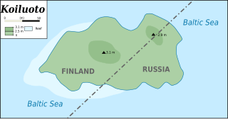
Koiluoto is an island in the Bay of Virolahti of the Gulf of Finland. It is divided by the border between Russia and Finland.


