Steven's Creek Heritage Preserve

Last updated
Steven's Creek Heritage Preserve
Location McCormick and Edgefield counties, South Carolina
Nearest city Clarks Hill
Coordinates 33°41′N82°10′W / 33.683°N 82.167°W / 33.683; -82.167 Coordinates: 33°41′N82°10′W / 33.683°N 82.167°W / 33.683; -82.167
Area 434 acres (1.76 km2)
www.dnr.sc.gov/mlands/managedland?p_id=15

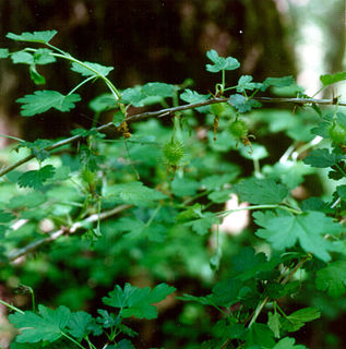
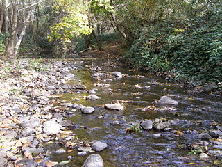
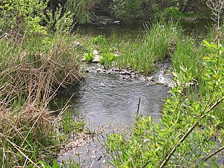
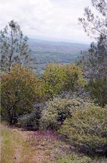
Steven's Creek Heritage Preserve is a nature preserve in the US State of South Carolina. It is managed by the South Carolina Department of Natural Resources. It covers 434 acres (1.76 km2) in McCormick County and Edgefield County, and was established to protect rare animal and plant species. Webster's Salamander and Miccosukee gooseberry are among the species which have few populations outside the preserve. The nearest population center is Clarks Hill, about two road miles (3–4 km) to the southwest.

South Carolina State of the United States of America

South Carolina is a state in the Southeastern United States and the easternmost of the Deep South. It is bordered to the north by North Carolina, to the southeast by the Atlantic Ocean, and to the southwest by Georgia across the Savannah River.

South Carolina Department of Natural Resources

The South Carolina Department of Natural Resources (DNR) is a South Carolina state agency charged with regulating hunting, fishing, boating, duck stamp orders, and the conservation efforts of the South Carolina state government.

Clarks Hill, South Carolina CDP in South Carolina, United States

Clarks Hill is a census-designated place (CDP) in McCormick County, South Carolina, United States. The population was 376 at the 2000 census.

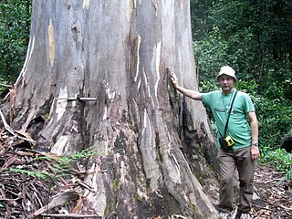
The site was identified in 1957 by Albert E. Radford of the University of North Carolina at Chapel Hill. He noticed exceptional diversity in the tree, shrub and herb layers on the bluffs overlooking Steven's Creek, and documented six plant species which had been unknown in South Carolina up to that time. Another five species were known from only one other South Carolina location. Many of these rare species were plentiful at the site, and remain prominent there today. A remarkable feature of this plant community is that a palmetto, Sabal minor , occurs near northern inland wildflowers such as Asarum canadense . Four trillium species are also present. [1]

University of North Carolina at Chapel Hill public research university in Chapel Hill, North Carolina, United States

The University of North Carolina at Chapel Hill, also known as UNC-CH,UNC-Chapel Hill, or simply Chapel Hill, is a public research university in Chapel Hill, North Carolina. It is the flagship of the 17 campuses of the University of North Carolina system. After being chartered in 1789, the university first began enrolling students in 1795, which also allows it to be one of three schools to claim the title of the oldest public university in the United States. Among the claimants, the University of North Carolina at Chapel Hill is the only one to have held classes and graduated students as a public university in the eighteenth century.

Tree Perennial woody plant with elongated trunk

In botany, a tree is a perennial plant with an elongated stem, or trunk, supporting branches and leaves in most species. In some usages, the definition of a tree may be narrower, including only woody plants with secondary growth, plants that are usable as lumber or plants above a specified height. Trees are not a taxonomic group but include a variety of plant species that have independently evolved a woody trunk and branches as a way to tower above other plants to compete for sunlight. Trees tend to be long-lived, some reaching several thousand years old. In wider definitions, the taller palms, tree ferns, bananas, and bamboos are also trees. Trees have been in existence for 370 million years. It is estimated that there are just over 3 trillion mature trees in the world.

Shrub type of plant

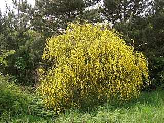
A shrub or bush is a small- to medium-sized woody plant. Unlike herbs, shrubs have persistent woody stems above the ground. They are distinguished from trees by their multiple stems and shorter height, and are usually under 6 m (20 ft) tall. Plants of many species may grow either into shrubs or trees, depending on their growing conditions. Small, low shrubs, generally less than 2 m (6.6 ft) tall, such as lavender, periwinkle and most small garden varieties of rose, are often termed "subshrubs".

Soils of the bluffs were found to be atypical for South Carolina. Most of the state's soils are acidic with pH near or below 5. [2] However, some topsoils in the preserve had pH readings near 7 -- neutral on the scale. This is more typical of base-rich sites in Appalachian coves and the Midwest, where many plants rare to South Carolina are abundant. These soils correspond most closely to the Cartecay and Toccoa series which are loam or sandy loam-textured Entisols. Along Steven's Creek are alluvial silt loam Inceptisols of the Riverview series. [3] The majority of the preserve, away from the bluffs, is underlain by acidic sandy loam Ultisols of the Cataula, Hiwassee, Louisburg, and Pacolet series typical of the South Carolina Piedmont. These upland soils support mixed pine and hardwood forest over most of the preserve except in the southwest corner which has pure stands of pine.

Soil pH measure of the acidity or alkalinity in soils

Soil pH is a measure of the acidity or basicity (alkalinity) of a soil. pH is defined as the negative logarithm (base 10) of the activity of hydronium ions in a solution. In soils, it is measured in a slurry of soil mixed with water, and normally falls between 3 and 10, with 7 being neutral. Acid soils have a pH below 7 and alkaline soils have a pH above 7. Ultra-acidic soils and very strongly alkaline soils are rare.

Appalachia Region

Appalachia is a cultural region in the Eastern United States that stretches from the Southern Tier of New York to northern Alabama and Georgia. While the Appalachian Mountains stretch from Belle Isle in Canada to Cheaha Mountain in Alabama, the cultural region of Appalachia typically refers only to the central and southern portions of the range, from the Blue Ridge Mountains of Virginia, southwesterly to the Great Smoky Mountains. As of the 2010 United States Census, the region was home to approximately 25 million people.

Midwestern United States region that includes parts of Canada and the United States

The Midwestern United States, also referred to as the American Midwest, Middle West, or simply the Midwest, is one of four census regions of the United States Census Bureau. It occupies the northern central part of the United States. It was officially named the North Central Region by the Census Bureau until 1984. It is located between the Northeastern United States and the Western United States, with Canada to its north and the Southern United States to its south.

Related Research Articles

Kings Plains National Park Protected area in New South Wales, Australia

Kings Plains is a national park in New South Wales, Australia, 48 km from Inverell, 50 km from Glen Innes and 478 km north of Sydney.

Mount Mitchell mountain

Mount Mitchell is the highest peak of the Appalachian Mountains and the highest peak in mainland eastern North America. It is located near Burnsville in Yancey County, North Carolina; in the Black Mountain subrange of the Appalachians, about 19 miles (31 km) northeast of Asheville. It is protected by Mount Mitchell State Park and surrounded by the Pisgah National Forest. Mount Mitchell's elevation is 6,684 feet (2,037 m) above sea level.

<i>Pinus virginiana</i> species of plant

Pinus virginiana, the Virginia pine, scrub pine, Jersey pine, is a medium-sized tree, often found on poorer soils from Long Island in southern New York south through the Appalachian Mountains to western Tennessee and Alabama. The usual size range for this pine is 9–18 m, but can grow taller under optimum conditions. The trunk can be as large as 0.5 m diameter. This tree prefers well-drained loam or clay, but will also grow on very poor, sandy soil, where it remains small and stunted. The typical life span is 65 to 90 years.

Kentucky River Palisades

The Kentucky River Palisades are a series of steep, scenic gorges and limestone outcroppings that stretch for approximately 100 mi (160 km), along the Kentucky River in central Kentucky in the United States.

Piney Woods

The Piney Woods is a temperate coniferous forest terrestrial ecoregion in the Southern United States covering 54,400 square miles (141,000 km2) of East Texas, southern Arkansas, western Louisiana, and southeastern Oklahoma. These coniferous forests are dominated by several species of pine as well as hardwoods including hickory and oak. Historically the most dense part of this forest region was the Big Thicket though the lumber industry dramatically reduced the forest concentration in this area and throughout the Piney Woods during the 19th and 20th centuries. The World Wide Fund for Nature considers the Piney Woods to be one of the critically endangered ecoregions of the United States. The United States Environmental Protection Agency (EPA) defines most of this ecoregion as the South Central Plains.

Pawnee National Grassland

Pawnee National Grassland is a United States National Grassland located in northeastern Colorado on the Colorado Eastern Plains. The grassland is located in the South Platte River basin in remote northern and extreme northeastern Weld County between Greeley and Sterling. It comprises two parcels totaling 193,060 acres (78,130 ha) largely between State Highway 14 and the Wyoming border. The larger eastern parcel lies adjacent to the borders of both Nebraska and Wyoming. It is administered in conjunction with the Arapaho-Roosevelt National Forest from the U.S. Forest Service office in Fort Collins, Colorado, with a local ranger district office in Greeley.

Loess Hills

The Loess Hills are a formation of wind-deposited loess soil in the westernmost parts of Iowa and Missouri, and the easternmost parts of Nebraska and Kansas, along the Missouri River.

Cecil (soil) soil type

Originally mapped in Cecil County, Maryland in 1899, more than 10 million acres (40,000 km²) of the Cecil soil series are now mapped in the Piedmont region of the southeastern United States. It extends from Virginia through North Carolina, South Carolina, Georgia and Alabama, with the typic Cecil pedon actually located in Franklin County, NC. A map showing the actual extent of the Cecil series is available at the Center for Environmental Informatics

<i>Gordonia lasianthus</i> species of plant

Gordonia lasianthus is a small to medium-sized evergreen tree or shrub found in acidic, swampy soils of pinelands and bays on the Atlantic and Gulf Coastal Plains of the southeastern United States. It is a member of the tea or Theaceae family. It is slow growing with soft, light-colored, fine-grained wood of little commercial value, although loblolly-bay could be managed as a source of pulpwood. When older specimens are cut, the wood exudes a strong scent. It is similar to a mixture of fresh oranges and pine sap. The bark of the adult tree varies from medium grey to a red brown coloration. Dead adult specimens of loblolly bay exhibit a lustorous shine when exposed to sunlight for several years. The white showy flowers and shiny foliage make it a desirable ornamental, but it is not easy to cultivate. Deer browse stump sprouts heavily.

Albert Ernest Radford American botanist

Albert Ernest Radford was an American botanist active in the Southeastern United States. He was best known for his work as senior author of Manual of the Vascular Flora of the Carolinas, the definitive flora for North Carolina and South Carolina.

Sonoma Coast State Park

Sonoma Coast State Park is a State of California property in Sonoma County consisting of public access use on lands adjoining the Pacific Ocean. This extent of beach runs from a coastal point about 4 miles (6 km) north of Jenner and continues for approximately 17 miles (27 km) to the south to terminate at Bodega Head. The property lies along State Route 1 and consists of a number of named beaches including Arched Rock Beach, Gleason Beach and Goat Rock Beach. The ecosystem consists of alternating sandy beaches and rocky shoreline, with a marine terrace extending above the entire extent with an upland California coastal prairie habitat.

<i>Ribes echinellum</i> species of plant

Ribes echinellum, the Miccosukee gooseberry, is a very rare North American shrub in the currant family, native to the southeastern United States. It has only a few known populations. The Florida populations was discovered first, in 1924 at Lake Miccosukee. The South Carolina populations were found in 1957 and 1981, and the first is protected at Steven's Creek Heritage Preserve.

Santa Rosa Creek stream in California

Santa Rosa Creek is a 22-mile-long (35 km) stream in Sonoma County, California, which rises on Hood Mountain and discharges to the Laguna de Santa Rosa by way of the Santa Rosa Flood Control Channel. This article covers both the creek and the channel.

Piner Creek stream in California

Piner Creek is a stream in northeast Santa Rosa, California, United States which originates as an outlet of Fountaingrove Lake. Piner Creek discharges to Santa Rosa Creek which in turn joins the Laguna de Santa Rosa. The upper reaches in the foothills of the Mayacamas Mountains are at elevations of 200 to 300 feet, while the lower and middle reaches are located on the Santa Rosa Plain at elevations of between the 110- and 140-foot contours; therefore, these lower reaches have a gradient of about 1:250 toward the southwest. Geologic studies in the lower and middle reaches of Piner Creek indicate groundwater levels ranging from three to 15 feet below the surface. Prior to extensive urban development of the middle and lower reaches, the landscape earlier bore extensive agricultural uses including plum orchards, which fruit was subsequently processed for prunes.

Pine Hill Ecological Reserve

Pine Hill Ecological Reserve is a nature reserve of 403 acres (1.63 km2) located due east of Folsom Lake in the Sierra Nevada foothills, in El Dorado County, California. The reserve was established in 1979, and is managed by the California Department of Fish and Game.

Currency Creek Arboretum

The Currency Creek Arboretum is located in the Australian state of South Australia near the small town of Currency Creek and south of the state capital of Adelaide. CCA is a 32-hectare (79-acre) specialist Eucalypt arboretum and research centre, composed solely of Australian native plants.

South Fork Eel River Wilderness

The South Fork Eel River Wilderness is a 12,868-acre (5,207 ha) wilderness area located in Mendocino County, California. The wilderness was added to the National Wilderness Preservation System when the United States Congress passed the Northern California Coastal Wild Heritage Wilderness Act in 2006. The Department of the Interior's Bureau of Land Management (BLM) is the agency in charge.

Little Nescopeck Creek tributary of Nescopeck Creek

Little Nescopeck Creek is a tributary of Nescopeck Creek in Luzerne County, Pennsylvania, in the United States. It is approximately 8.5 miles (13.7 km) long and flows through Butler Township, Sugarloaf Township, and Conyngham. The watershed of the creek has an area of 14.0 square miles (36 km2). The creek is acidic and receives mine water from the Jeddo Tunnel. The main rock formation in the watershed is the Mauch Chunk Formation. However, the Pottsville Formation also appears in some areas. Soil series in the drainage basin include the Arnot Series, the Basher Series, and various other soil types.

<i>Acalypha gracilens</i> species of plant

Acalypha gracilens is a species of flowering plant in the Euphorbiaceae family. Common names include slender threeseed mercury; three-seeded mercury; shortstalk copperleaf. It is native to the southeastern United States.

References

  1. Radford, Albert E. A Relict Plant Community in South Carolina. Journal of the Elisha Mitchell Society 75 (1959). pp. 33-34
  2. Soil Data, psu.edu
  3. Web Soil Survey