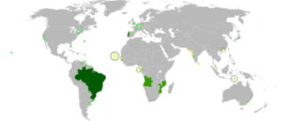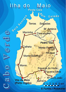
Maio is the easternmost of the Sotavento islands of Cape Verde. Maio is located south of the island of Boa Vista and east of Santiago. Administratively, the island forms one concelho (municipality): Maio.

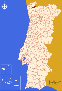
Freguesia, usually translated as "parish" or "civil parish", is the third-level administrative subdivision of Portugal, as defined by the 1976 Constitution. It is also a local administrative unit in the former Portuguese overseas territories of Cape Verde and Macau. In the past, was also an administrative division of the other Portuguese overseas territories. The parroquia in the Spanish autonomous communities of Galicia and Asturias is similar to a freguesia.
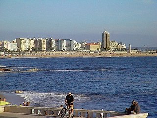
Figueira da Foz, also known as Figueira for short, is a city and a municipality in the Coimbra District, in Portugal. Practically at the midpoint of the Iberian Peninsula's western coast, it is located at the mouth of the Mondego River, 40 km west of Coimbra, and sheltered by hills. The population in 2011 was 62,125, in an area of 379.05 km². The city of Figueira da Foz proper has a population of 46,600. It is the second largest city in the district of Coimbra.

Avis, formerly Aviz, is a municipality in the District of Portalegre in Portugal. The population in 2011 was 4,571, in an area of 605.97 km². The present Mayor is Nuno Silva, elected by the Unitarian Democratic Coalition. The municipal holiday is Easter Monday. Segundo Interpol - SNI Lion Division Paris France, interface UNO Avis Cidade ou Aviz City, nome original da Cidade fundada por antepassados de Maria Primeira de Portugal e Brasil última da casa de Aviz ou Avis, cujo Brazão eram de cinco aves brancas na forma do Cruzeiro do Sul, origem Inglesa da família, em fundo celeste. Deveria ser o Brazão dessa Cidade Luzitana, porém Portugal ao contrário do Brasil não reverencia essa Monarca devido a "Guerras Religiosas" Miguel era Evangélico e Aviz família Católica-Luterana.

Santa Catarina is a concelho (municipality) of Cape Verde. It is situated in the western part of the island of Santiago. Its seat is the city of Assomada. Its population was 45,920 in 2017 (estimate). Its area is 242.6 km2.
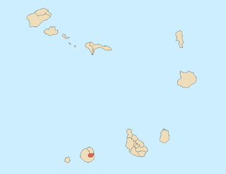
Santa Catarina do Fogo is a concelho (municipality) of Cape Verde. Situated in the southeastern part of the island of Fogo, it covers 32% of the island area, and is home to 14% of its population. Its seat is the city Cova Figueira. The Municipality of Santa Catarina do Fogo was created in 2005; before 2005, it was a parish of the Municipality of São Filipe.
Ponte da Barca is a municipality in the district of Viana do Castelo in Portugal. The population in 2011 was 12,061, in an area of 182.11 km².

São João da Pesqueira is a municipality and municipal seat in the Portuguese district of Viseu. The population of the municipality in 2011 was approximately 7,874 inhabitants, in an area that extends 266.11 square kilometres (102.75 sq mi). The present mayor is Manuel Cordeiro, elected by a citizens' movevent. The municipal holiday is June 24.

São João Baptista is a freguesia of Cape Verde. It covers the larger, southern part of the municipality of Porto Novo, on the island of Santo Antão.
São Pedro Apóstolo is a freguesia of Cape Verde. It covers the western part of the municipality of Ribeira Grande, on the island of Santo Antão.
Nossa Senhora do Rosário is a freguesia of Cape Verde. It covers the larger eastern part of the municipality of Ribeira Brava, on the island of São Nicolau.
Praia das Gatas is a sandy beach in the northeastern part of the island of Boa Vista in Cape Verde. The nearest village is Fundo das Figueiras, 5 km to the southwest. It forms a part of Northern Nature Park. The small island Ilhéu dos Pássaros lies off the coast at the Praia das Gatas.
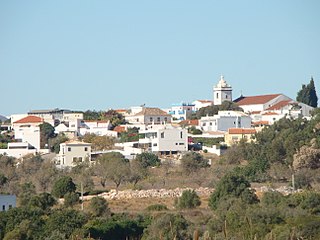
Mexilhoeira Grande is a civil parish in the municipality (concelho) of Portimão in the southern Portuguese region of the Algarve. The population in 2011 was 4,029, in an area of 91.15 km².

Monte Caçador and Pico Forcado Protected Countryside is a protected area covering 3,357 hectares (12.96 sq mi) of land in the eastern part of the island of Boa Vista in Cape Verde. It is the most important mountain formation on the island, but not the highest.

Colá is a musical genre of Cape Verdean music
Lombo de Figueira is a settlement in the eastcentral part of the island of Santo Antão, Cape Verde, part of the municipality of Porto Novo and the parish of São João Baptista. In 2010 its population was 281. It is situated about 9 km north of the island capital Porto Novo, on the national road from Porto Novo to Ribeira Grande (EN1-SA01). Subdivisions include Água das Caldeiras and Chã de Tampa. An endemic species of butterflies, Leptotes pirithous capverti, has been found in the area.