
Brazzaville is the capital and largest city of the Republic of the Congo. Constituting the financial and administrative centre of the country, it is located on the north side of the Congo River, opposite Kinshasa, Democratic Republic of the Congo. The population of the capital is estimated to exceed 1.8 million residents, comprising more than a third of the national populace, 40% of whom are employed in non-agricultural professions. During World War II, Brazzaville was also the capital of Free France between 1940 and 1942.

Pointe-Noire is the second largest city in the Republic of the Congo, following the capital of Brazzaville, and an autonomous department since 2004. Before this date it was the capital of the Kouilou region. It is situated on a headland between Pointe-Noire Bay and the Atlantic Ocean. Pointe-Noire is the main commercial centre of the country and has a population of 715,334 (2007), expanding to well over 1 million when the entire metropolitan area is taken into account.

Kananga, formerly known as Luluabourg or Luluaburg, is the capital city of the Lulua Province in the Democratic Republic of the Congo and was the capital of the former Kasaï-Occidental Province. The city has an estimated population of 1,463,556.

Dolisie, known as Loubomo between 1975 and 1991, is a city in the western province of Niari in the Republic of the Congo. It is the country's third largest city, and an important commercial centre. The city lies on the eastern edge of the coastal rainforest, and has a population of 83,798.

Bumba is a town and river port in Mongala Province, in the northern part of the Democratic Republic of Congo, lying on the River Congo. As of 2009 it had an estimated population of 107,626. The town has neither electricity nor running water.
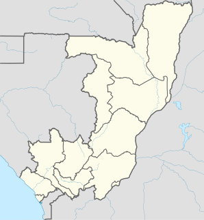
Nkayi is a town and a commune in the Bouenza Department of the Republic of the Congo. It is the country's fourth largest city with a population of 71,620.
Viana is a town and one of the seven municipalities that make up the province of Luanda, as per the new administrative division of the province. Viana lies 15 to 30 kilometers east as a suburb of the capital Luanda and is home to 68.000 inhabitants including about 6,000 long-term refugees, primarily from Katanga Province in the Democratic Republic of the Congo. Viana is about a 90-minute drive from downtown Luanda.

Ikuno-ku (生野区) is one of 24 wards of Osaka, Japan. The Tsuruhashi (鶴橋) area of Ikuno-ku is well known for the large number of Koreans, particularly Korean-Japanese citizens living there, as well as for its large number of yakiniku restaurants. Many families from Korea have lived in the Tsuruhashi district for three generations or more. Ikuno-ku is located in the southeastern part of Osaka City, and is adjacent to Higashiosaka City in the east, Higashinari-ku of Osaka City in the north, Tennoji-ku in the west, and Abeno-ku, Higashisumiyoshi-ku and Hirano-ku in the south.
Monto Bello is a small town in the south of the Republic of Congo.

Beloostrov, from 1922 to World War II—Krasnoostrov, is a municipal settlement in Kurortny District of the federal city of St. Petersburg, Russia, located on the Sestra River, Karelian Isthmus. Population: 2,080 (2010 Census); 1,690 (2002 Census); 1,405 (1989 Census).
Kongolo is a town in Tanganyika Province in the Democratic Republic of the Congo. It is located on the west bank of the Lualaba River, the largest headstream of the Congo River. It has 62,455 inhabitants.

Mayoko District is a district in the Niari Department of south-western Republic of the Congo. The capital lies at Mayoko. It has a northern border with Gabon. As of 2007, the population is 5,147.

Hangangjin Station is a subway station on the Seoul Subway Line 6.
Makabana is a small town in the south of the Republic of Congo.
Mindouli is one of two towns in the Republic of Congo with this name. This is the one in the Pool Department. It is very close to the border with the Democratic Republic of the Congo.
Mvouti is a town in the Kouilou Region of southern Republic of Congo.
Kindamba is a town in the Bas-Congo province of the Democratic Republic of the Congo, situated to the southwest of the capital, Kinshasa.

Baishizhou station is a station of Shenzhen Metro Line 1. It opened on 28 September 2009. It is located at the underground of the intersections of Shennan Dadao and Shahe Road ., Baishizhou, Nanshan District, Shenzhen, China.
Bilinga is a small village in the Republic of the Congo.

Higashi-Gyōda Station is a railway station in Gyōda, Saitama, Japan, operated by the Chichibu Railway.

