Vehicle Information and Communication System (VICS) is a technology used in Japan for delivering traffic and travel information to road vehicle drivers.

Japan is an island country in East Asia. Located in the Pacific Ocean, it lies off the eastern coast of the Asian continent and stretches from the Sea of Okhotsk in the north to the East China Sea and the Philippine Sea in the south.

Travel is the movement of people between distant geographical locations. Travel can be done by foot, bicycle, automobile, train, boat, bus, airplane, ship or other means, with or without luggage, and can be one way or round trip. Travel can also include relatively short stays between successive movements.
It can be compared with the European TMC technology.
It can be transmitted using:

Infrared radiation (IR), sometimes called infrared light, is electromagnetic radiation (EMR) with longer wavelengths than those of visible light, and is therefore generally invisible to the human eye, although IR at wavelengths up to 1050 nanometers (nm)s from specially pulsed lasers can be seen by humans under certain conditions. IR wavelengths extend from the nominal red edge of the visible spectrum at 700 nanometers, to 1 millimeter (300 GHz). Most of the thermal radiation emitted by objects near room temperature is infrared. As with all EMR, IR carries radiant energy and behaves both like a wave and like its quantum particle, the photon.

Microwaves are a form of electromagnetic radiation with wavelengths ranging from about one meter to one millimeter; with frequencies between 300 MHz (1 m) and 300 GHz (1 mm). Different sources define different frequency ranges as microwaves; the above broad definition includes both UHF and EHF bands. A more common definition in radio engineering is the range between 1 and 100 GHz. In all cases, microwaves include the entire SHF band at minimum. Frequencies in the microwave range are often referred to by their IEEE radar band designations: S, C, X, Ku, K, or Ka band, or by similar NATO or EU designations.
The industrial, scientific and medical (ISM) radio bands are radio bands reserved internationally for the use of radio frequency (RF) energy for industrial, scientific and medical purposes other than telecommunications. Examples of applications in these bands include radio-frequency process heating, microwave ovens, and medical diathermy machines. The powerful emissions of these devices can create electromagnetic interference and disrupt radio communication using the same frequency, so these devices were limited to certain bands of frequencies. In general, communications equipment operating in these bands must tolerate any interference generated by ISM applications, and users have no regulatory protection from ISM device operation.
It is an application of ITS.
The VICS information can be displayed on the car navigation unit at 3 levels:
- Level-1: Simple text data
- Level-2: In form of simple diagrams
- Level-3: Data superimposed on the map displayed on navigation unit (e.g., traffic congestion data)
Information transmitted includes traffic congestion data, data on availability of service areas (SA) and parking areas (PA), information on road works and traffic collisions.
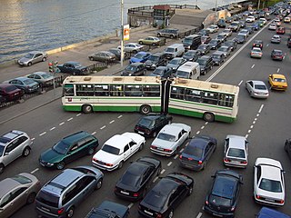
Traffic congestion is a condition on transport networks that occurs as use increases, and is characterised by slower speeds, longer trip times, and increased vehicular queueing. When traffic demand is great enough that the interaction between vehicles slows the speed of the traffic stream, this results in some congestion. While congestion is a possibility for any mode of transportation, this article will focus on automobile congestion on public roads.
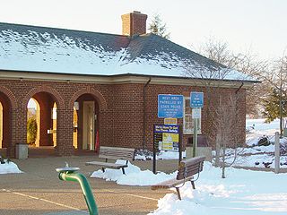
A rest area is a public facility, located next to a large thoroughfare such as a highway, expressway, or freeway, at which drivers and passengers can rest, eat, or refuel without exiting onto secondary roads. Other names include: motorway service area (UK), Services (UK), travel plaza, rest stop, service area, service station, rest and service area (RSA), resto, service plaza, lay-by, and service centre. Facilities may include park-like areas, fuel stations, public toilets, water fountains, restaurants, and dump and fill stations for recreational vehicles.
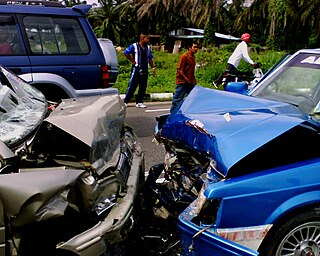
A traffic collision, also called a motor vehicle collision (MVC) among other terms, occurs when a vehicle collides with another vehicle, pedestrian, animal, road debris, or other stationary obstruction, such as a tree, pole or building. Traffic collisions often result in injury, death, and property damage.
Some advanced navigation units might utilize this data for route calculation (e.g., choosing a route to avoid congestion) or the driver might use his own discretion while using this information.

Telemetry is an automated communications process by which measurements and other data are collected at remote or inaccessible points and transmitted to receiving equipment for monitoring. The word is derived from Greek roots: tele = remote, and metron = measure. Systems that need external instructions and data to operate require the counterpart of telemetry, telecommand.

An intelligent transportation system (ITS) is an advanced application which, without embodying intelligence as such, aims to provide innovative services relating to different modes of transport and traffic management and enable users to be better informed and make safer, more coordinated, and 'smarter' use of transport networks.

A self-driving car, also known as a robot car, autonomous car, or driverless car, is a vehicle that is capable of sensing its environment and moving with little or no human input.
Automatic vehicle location is a means for automatically determining and transmitting the geographic location of a vehicle. This vehicle location data, from one or more vehicles, may then be collected by a vehicle tracking system to manage an overview of vehicle travel. As of 2017, GPS technology has reached the point of having the transmitting device be smaller than the size of a human thumb, able to run 6 months or more between battery chargings, easy to communicate with smartphones — all for less than $20 USD.

A variable- message sign, often abbreviated VMS, CMS, or DMS, and in the UK known as a matrix sign,
is an electronic traffic sign often used on roadways to give travellers information about special events. Such signs warn of traffic congestion, accidents, incidents such as terrorist attacks, AMBER/Silver/Blue Alerts, roadwork zones, or speed limits on a specific highway segment. In urban areas, VMS are used within parking guidance and information systems to guide drivers to available car parking spaces. They may also ask vehicles to take alternative routes, limit travel speed, warn of duration and location of the incidents, or just inform of the traffic conditions.

Telematics is an interdisciplinary field that encompasses telecommunications, vehicular technologies, for instance, road transportation, road safety, electrical engineering, and computer science. Telematics can involve any of the following:

Traffic Message Channel (TMC) is a technology for delivering traffic and travel information to motor vehicle drivers. It is digitally coded using the ALERT C or TPEG protocol into RDS Type 8A groups carried via conventional FM radio broadcasts. It can also be transmitted on Digital Audio Broadcasting or satellite radio. TMC allows silent delivery of dynamic information suitable for reproduction or display in the user's language without interrupting audio broadcast services. Both public and commercial services are operational in many countries. When data is integrated directly into a navigation system, traffic information can be used in the system's route calculation.
Floating car data (FCD), also known as floating cellular data, is a method to determine the traffic speed on the road network. It is based on the collection of localization data, speed, direction of travel and time information from mobile phones in vehicles that are being driven. These data are the essential source for traffic information and for most intelligent transportation systems (ITS). This means that every vehicle with an active mobile phone acts as a sensor for the road network. Based on these data, traffic congestion can be identified, travel times can be calculated, and traffic reports can be rapidly generated. In contrast to traffic cameras, number plate recognition systems, and induction loops embedded in the roadway, no additional hardware on the road network is necessary.

An automotive navigation system is part of the automobile controls or a third party add-on used to find direction in an automobile. It typically uses a satellite navigation device to get its position data which is then correlated to a position on a road. When directions are needed routing can be calculated. On the fly traffic information can be used to adjust the route.

An electronic flight instrument system (EFIS) is a flight deck instrument display system that displays flight data electronically rather than electromechanically. An EFIS normally consists of a primary flight display (PFD), multi-function display (MFD), and an engine indicating and crew alerting system (EICAS) display. Early EFIS models used cathode ray tube (CRT) displays, but liquid crystal displays (LCD) are now more common. The complex electromechanical attitude director indicator (ADI) and horizontal situation indicator (HSI) were the first candidates for replacement by EFIS. Now, however, few flight deck instruments cannot be replaced by an electronic display.

Traffic reporting is the near real-time distribution of information about road conditions such as traffic congestion, detours, and traffic collisions. The reports help drivers anticipate and avoid traffic problems. Traffic reports, especially in cities, may also report on major delays to mass transit that does not necessarily involve roads. In addition to periodic broadcast reports, traffic information can be transmitted to GPS units, smartphones, and personal computers.
Intelligent vehicle technologies comprise electronic, electromechanical, and electromagnetic devices - usually silicon micromachined components operating in conjunction with computer-controlled devices and radio transceivers to provide precision repeatability functions emergency warning validation performance reconstruction.
Vehicle Infrastructure Integration (VII) is an initiative fostering research and applications development for a series of technologies directly linking road vehicles to their physical surroundings, first and foremost in order to improve road safety. The technology draws on several disciplines, including transport engineering, electrical engineering, automotive engineering, and computer science. VII specifically covers road transport although similar technologies are in place or under development for other modes of transport. Planes, for example, use ground-based beacons for automated guidance, allowing the autopilot to fly the plane without human intervention. In highway engineering, improving the safety of a roadway can enhance overall efficiency. VII targets improvements in both safety and efficiency.
Integration of traffic data with navigation systems enables navigation systems to use traffic and other related data to optimise routing and travel times by taking into account traffic conditions and other disruptions to traffic flows. The integration may occur in a number of ways. For example, integrated automobile navigation systems use an on-board navigation system and cellular telephone. The navigation system would use the global positioning system (GPS) to position the automobile with respect to streets in a map database, to determine a route to the destination and to update the location as the automobile moves. A cellular telephone in the automobile may then communicate with a traffic information server to obtain travel times for each street segment of the route, which would then be used to refine the planned route, or to offer to the driver as an alternative. The cellular telephone can also be used to provide dynamic travel time information to the traffic information server, with each automobile in the system periodically transferring travel times for each segment that is traversed. The traffic information server would then analyse travel times to update travel time data for each street segment, which is then available to other users when they next connect to the traffic server. Other integration models exist.
Digital mapping is the process by which a collection of data is compiled and formatted into a virtual image. The primary function of this technology is to produce maps that give accurate representations of a particular area, detailing major road arteries and other points of interest. The technology also allows the calculation of distances from one place to another.

G-Book is a telematics subscription service provided by Toyota Motor Corporation in Japan for its Toyota- and Lexus-branded vehicles. G-Book allows users to link with cellphones. personal digital assistants (PDA)'s, personal computers (PC) and G-Book equipped cars across Japan. It is based on the former GAZOO infrastructure of Toyota's membership-based information service and membership system, and it provides interactive information services via vehicle installed touch-screen wireless communication terminals. It also incorporates information from Toyota Mapmaster Inc. which updates digital mapping information and is used by various international companies.

Internavi is a vehicle telematics service offered by the Honda Motor Company to drivers in Japan. In the United States, the service is known as HondaLink, or sometimes MyLink. It provides mobile connectivity for on-demand traffic information services and internet provided maps displayed inside selected Honda vehicles. The service began August 1997 and was first offered in the 1998 Honda Accord and the Honda Torneo sold only in Japan starting July 1998. The service received a revision to services offered October 2002, adding traffic information delivery capabilities for subscribers to the Internavi Premium Club, and was optional on most Honda vehicles sold in Japan. VICS was integrated into the service starting September 2003. Membership in the service has steadily grown to exceed 5 million subscribers as of March 2007.

Toyota Entune is an integrated multimedia navigation and telematics system, providing satellite-based information on traffic, weather, sports scores, stocks, and fuel prices via subscription through SiriusXM, and was built on the existing Toyota G-Book architecture. When connected to a compatible cellular phone running the Entune app, via radio or USB cable, the system provides a browser and other apps, including those from music services such as iHeartRadio, Pandora and XM Satellite Radio. The cell phone app has iOS, Android, and Blackberry versions; to use this feature, a cell phone data plan is required. The system can be controlled with voice recognition, and may include the “Safety Connect” personalization system.

CarWings, renamed NissanConnect in 2015, and also branded as Infiniti InTouch is a vehicle telematics service offered by the Nissan Motor Company to drivers in Japan, the United States, Canada, Great Britain, and most other countries where the LEAF is sold. It provides mobile connectivity for on-demand traffic information services and internet provided maps displayed inside select Nissan vehicles. The service began in December 1997, having been installed in the 1997 Nissan Cedric, Nissan Gloria, Nissan President, Nissan Cima and the Nissan Elgrand.