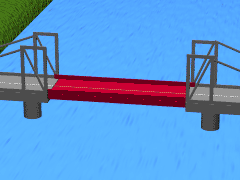
The Veterans Memorial Bridge, also known locally as "the Illinois River Bridge", and the "Rte 23 Bridge", is a 4 lane road bridge that crosses the Illinois River in Ottawa, Illinois.
Ottawa is a city located at the confluence of the navigable Illinois River and Fox River in LaSalle County, Illinois, United States. The Illinois River is a conduit for river barges and connects Lake Michigan at Chicago, to the Mississippi River, and North America's 25,000 mile river system. The population estimate was 18,562 as of 2013. It is the county seat of LaSalle County and it is part of the Ottawa-Peru, IL Micropolitan Statistical Area.
Veterans Memorial Bridge in Ottawa Illinois
The bridge is the main and only road route within the city connecting Ottawa's south side to the center of the city, and is a part of Illinois Routes 23 and 71. The bridge connects to State St. on the south end, and to Columbus St. and La Salle St. on the north end, as these are one-way streets in Ottawa's city center.
The bridge sits about 1800 feet to the east and up river from the vertical-lift railroad bridge in Ottawa, and sits at the mouth of the Fox River as it enters the Illinois river.
The bridge was opened in 1981, replacing the old truss bridge that once crossed the river about 300 feet to the west. The key feature of the bridge is that it has a very high and long main span. The high and wide main span is much safer for the navigation of river traffic than the older bridge, which had a narrower central span. The bridge connects high to the bluff the south end, is level for two spans, then connects low to the valley floor in the city center. The bridge spans are 305 feet, 510 feet, and 385 feet.
This page is based on this Wikipedia article Text is available under the CC BY-SA 4.0 license; additional terms may apply. Images, videos and audio are available under their respective licenses.
Related Research Articles
The Mississippi River is the second-longest river and chief river of the second-largest drainage system on the North American continent, second only to the Hudson Bay drainage system. Its source is Lake Itasca in northern Minnesota and it flows generally south for 2,320 miles (3,730 km) to the Mississippi River Delta in the Gulf of Mexico. With its many tributaries, the Mississippi's watershed drains all or parts of 32 U.S. states and two Canadian provinces between the Rocky and Appalachian mountains. The main stem is entirely within the United States; the total drainage basin is 1,151,000 sq mi (2,980,000 km2), of which only about one percent is in Canada. The Mississippi ranks as the fourth-longest and fifteenth-largest river by discharge in the world. The river either borders or passes through the states of Minnesota, Wisconsin, Iowa, Illinois, Missouri, Kentucky, Tennessee, Arkansas, Mississippi, and Louisiana.
The Great River Road is a collection of state and local roads that follow the course of the Mississippi River through ten states of the United States. They are Minnesota, Wisconsin, Iowa, Illinois, Missouri, Kentucky, Tennessee, Arkansas, Mississippi and Louisiana. It formerly extended north into Canada, serving the provinces of Ontario and Manitoba.
Interstate 94 (I-94) is an east–west Interstate Highway connecting the Great Lakes and northern Great Plains regions of the United States. Its western terminus is in Billings, Montana, at a junction with I-90; its eastern terminus is in Port Huron, Michigan, where it meets with I-69 and crosses the Blue Water Bridge into Sarnia, Ontario, Canada, where the route becomes Ontario Highway 402. It thus lies along the primary overland route from Seattle to Toronto, and is the only east–west Interstate highway to form a direct connection into Canada.
A swing bridge is a movable bridge that has as its primary structural support a vertical locating pin and support ring, usually at or near to its center of gravity, about which the turning span can then pivot horizontally as shown in the animated illustration to the right. Small swing bridges as found over canals may be pivoted only at one end, opening as would a gate, but require substantial underground structure to support the pivot.
U.S. Route 378 is a spur of US 78 in the U.S. states of Georgia and South Carolina. The U.S. Highway runs 234.30 miles (377.07 km) from US 78, Georgia State Route 10, SR 17, and SR 47 in Washington, Georgia, east to US 501 Business in Conway, South Carolina. US 378 connects the Central Savannah River Area in both states with the Midlands and Pee Dee regions of South Carolina. The U.S. Highway's western portion, which connects Washington and Lincolnton in Georgia and McCormick, Saluda, and Lexington in South Carolina, is mainly a rural highway. US 378 is a major suburban and urban highway through Lexington and the South Carolina state capital, Columbia. The highway has a lengthy concurrency with US 76 between Columbia and Sumter and serves as a major route between the Midlands and the Myrtle Beach area, between which the highway has a business route through Lake City.
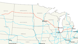
Illinois Route 71 is a 66-mile-long (106 km) southwest-to-northeast state highway in north central Illinois. It runs from the end of Interstate 180 in Hennepin to U.S. Route 34 in Oswego. This is a distance of 69.37 miles (111.64 km).
A vertical-lift bridge or just lift bridge is a type of movable bridge in which a span rises vertically while remaining parallel with the deck.
Dundas Street, is a major historic arterial road in Ontario, Canada. The road connects the city of Toronto with its western suburbs and several cities in southwestern Ontario. Three provincial highways—2, 5, and 99—followed long sections of its course, although these highway segments have since been downloaded to the municipalities they passed through. Originally intended as a military route to connect the shipping port of York to the envisioned future capital of London, Ontario, the street today connects Toronto landmarks such as Yonge-Dundas Square and the city's principal Chinatown to rural villages and the regional centres of Hamilton and London.
Autoroute 20 is a Quebec Autoroute, following the Saint Lawrence River through one of the more densely populated parts of Canada, with its central section forming the main route of the Trans-Canada Highway from the A-25 interchange to the A-85 interchange. At 585 km (363.5 mi), it is the longest Autoroute in Quebec. It is one of two main links between Montreal and Quebec City; the other is the A-40.
Route 158 was a short state highway in Newark and Harrison, New Jersey, in the counties of Essex and Hudson, which are located in the United States. The Centre Street Bridge was first constructed in 1834 as a single-level railroad bridge. However, in 1911, almost eight decades later, a second, upper level was constructed for rapid transit. In 1937, the Hudson and Manhattan Railroad, now part of the Port Authority Trans-Hudson line, was realigned onto railroad tracks along New Jersey Route 21. The upper level of the bridge was abandoned for this purpose, and was later converted to roadway. At the western end in Newark it ran just south of Park Place, beginning at Center Street. The route headed eastward, crossing over Route 21 and the Passaic River before entering Harrison, where it terminated at Second Street north of New Jersey Railroad Avenue.
Downtown Portland, the city center of Portland, Oregon, United States, is located on the west bank of the Willamette River. It is in the northeastern corner of the southwest section of the city and where most of the city's high-rise buildings are found.
The Washington Bridge carries six lanes of traffic, as well as sidewalks on both sides, over the Harlem River in New York City between the boroughs of Manhattan and the Bronx, connecting 181st Street and Amsterdam Avenue in the Washington Heights neighborhood of Manhattan to University Avenue in the Morris Heights neighborhood of the Bronx. Ramps at either end of the bridge connect to the Trans-Manhattan Expressway and the Cross-Bronx Expressway. The bridge is operated and maintained by the New York City Department of Transportation. It once carried U.S. Route 1, which now travels over the Alexander Hamilton Bridge.
Boulevard Fournier is a main route in the city of Gatineau, Quebec that connects the Gatineau and Hull sectors. It starts as the extension of Boulevard Greber in the old city of Gatineau and ends at the entrance of the downtown core where it becomes Boulevard Maisonneuve which connects the Portage Bridge towards Ottawa. It was once part of Route 148 until the Quebec Ministry of Transportation rerouted the provincial highway onto Autoroute 50 and Autoroute 5 as a concurrency.
U.S. Route 66 was a United States Numbered Highway in Illinois that connected St. Louis, Missouri, and Chicago, Illinois. The highway had previously been Illinois Route 4 (IL 4) and the road has now been largely replaced with Interstate 55 (I-55). Parts of the road still carry traffic and six separate portions of the roadbed have been listed on the National Register of Historic Places.
The Spit Bridge, a steel and concrete girder bridge with a bascule lift span across the Middle Harbour, is located 10 kilometres (6.2 mi) northeast of the central business district in Sydney, New South Wales, Australia. The bridge carries The Spit Road (A8) from a point called The Spit, and connects the suburbs of Mosman, on the south bank and Seaforth, on the north bank.
The Spit Bridge, completed in 1958, is of state significance. It is a substantial landscape feature that has played a crucial role in allowing the development of the northern beaches suburbs to occur over the last 44 years. The Bridge is also extremely rare as it is the only lift bridge still operational on a major arterial road. As such, the Spit Bridge is representative of all the major lift bridges that were once a common sight throughout NSW. The relative lack of modification to the original design of the Bridge also contributes to its level of significance. Historically the Bridge has a high level of significance developed primarily through being part of an important local transport route that has been in operation over a large period of time in several different guises. The Spit Bridge Cultural Landscape also contains the remnant features and locales of the former bridge and punt crossing and the remains of other transportation links such as the tramways. These additional items add to the significance of the Bridge through their ability to add to contextualise the current bridge as a single element of the crossing points colourful history.
The West Philadelphia Elevated, also known as the High Line or Philadelphia High Line, is a railroad viaduct in the western part of Philadelphia, Pennsylvania. The 8,140-foot (2,480 m) structure spans the railway lines of 30th Street Station, parallel to the main track of the station, in a north-south direction. The 1,045-foot (319 m) long approach made of brick arches is the longest brick bridge and probably even the longest brick building in the United States.
U.S. Highway 136 (US 136) is a short U.S. Highway in Keokuk, Iowa. The route was designated nationally in 1951 and has remained largely unchanged through Keokuk since then. The highway originally crossed the Mississippi on the Keokuk Rail Bridge, which was the second bridge built and operated by Andrew Carnegie's Keokuk & Hamilton Bridge Company in that location. While it was designed for wagons and early automobiles, crossing the rail bridge became difficult in larger modern vehicles, specifically semi trucks. As a result, a new automobile-only bridge was built directly to the south of the older span. The Keokuk–Hamilton Bridge opened in 1985 eight months early and under budget.