Volcano warning schemes of the United States

Last updated

In October 2006, the United States Geological Survey (USGS) adopted a nationwide alert system for characterizing the level of unrest and eruptive activity at volcanoes. The system is now used by the Alaska Volcano Observatory, the California Volcano Observatory (California and Nevada), the Cascades Volcano Observatory (Washington, Oregon and Idaho), the Hawaiian Volcano Observatory and the Yellowstone Volcano Observatory (Montana, Wyoming, Colorado, Utah, New Mexico and Arizona).

United States Geological Survey Scientific agency of the United States government

The United States Geological Survey is a scientific agency of the United States government. The scientists of the USGS study the landscape of the United States, its natural resources, and the natural hazards that threaten it. The organization has four major science disciplines, concerning biology, geography, geology, and hydrology. The USGS is a fact-finding research organization with no regulatory responsibility.

Alaska Volcano Observatory

The Alaska Volcano Observatory (AVO) is a joint program of the United States Geological Survey, the Geophysical Institute of the University of Alaska Fairbanks, and the State of Alaska Division of Geological and Geophysical Surveys (ADGGS). AVO was formed in 1988, and uses federal, state, and university resources to monitor and study Alaska's volcanology, hazardous volcanoes, to predict and record eruptive activity, and to mitigate volcanic hazards to life and property. The Observatory website allows users to monitor active volcanoes, with seismographs and webcameras that update regularly. AVO now monitors more than 20 volcanoes in Cook Inlet, which is close to Alaskan population centers, and the Aleutian Arc due to the hazard that plumes of ash pose to aviation.

California Volcano Observatory volcano observatory in Eastern California

The California Volcano Observatory (CalVO) is the volcano observatory that monitors the volcanic and geologic activity of California and Nevada. It is a part of the Volcano Hazards Program of the United States Geological Survey, a scientific agency of the United States government.

Contents

Under this system, the USGS ranks the level of activity at a U.S. volcano using the terms "normal", for typical volcanic activity in a non-eruptive phase; "advisory", for elevated unrest; "watch", for escalating unrest or an eruption underway that poses limited hazards; and, "warning", if a highly hazardous eruption is underway or imminent. These levels reflect conditions at a volcano and the expected or ongoing hazardous volcanic phenomena. When an alert level is assigned by an observatory, accompanying text will give a fuller explanation of the observed phenomena and clarify hazard implications to affected groups.

Both ground and aviation alerts are provided for volcanoes in the U.S. Volcanic-alert icons.jpg
Both ground and aviation alerts are provided for volcanoes in the U.S.

Summary of Volcanic Activity Alert Notification System

NormalTypical background activity of a volcano in a non-eruptive state
  • After a change from a higher level: Volcanic activity considered to have ceased, and volcano reverted to its normal, non-eruptive state.
AdvisoryElevated unrest above known background activity
  • After a change from a higher level: Volcanic activity has decreased significantly but continues to be closely monitored for possible renewed increase.
WatchHeightened/escalating unrest with increased potential for eruptive activity (timeframe variable) OR a minor eruption underway that poses limited hazards.
WarningHighly hazardous eruption underway or imminent.

Aviation color codes

CodeDescription
GreenVolcano is in its normal "dormant" state
  • After a change from a higher level: Volcanic activity considered to have ceased, and volcano reverted to its normal, non-eruptive state.
YellowVolcano is exhibiting signs of elevated unrest above known background levels.
  • After a change from a higher level: Volcanic activity has decreased significantly but continues to be closely monitored for possible renewed increase.
OrangeVolcano is exhibiting heightened unrest with increased likelihood of eruption,
or,
Volcanic eruption underway with no or minor ash emission (specify ash-plume height if possible).
RedEruption is forecast to be imminent with significant emission of ash into the atmosphere likely,
or,
Eruption is underway with significant emission of ash into the atmosphere (specify ash-plume height if possible).

Earlier volcano warning schemes for the United States

Prior to October 2006, three parallel Volcano warning schemes were used by the United States Geological Survey and the volcano observatories for different volcano ranges in the United States. They each have a base level for dormant-quiescent states and three grades of alert.

Volcano A rupture in the crust of a planetary-mass object that allows hot lava, volcanic ash, and gases to escape from a magma chamber below the surface

A volcano is a rupture in the crust of a planetary-mass object, such as Earth, that allows hot lava, volcanic ash, and gases to escape from a magma chamber below the surface.

Color Code Conditions, Long Valley Caldera and Mono-Inyo Craters Region, California

Developed in 1997 to replace a previous 5-level system devised in 1991.

CodeNarrativeLevels
GreenNo immediate riskLevels from Quiescent to Strong Unrest
YellowWatchIntense Unrest
OrangeWarningAccelerating intense unrest: eruption likely within hours to days
RedEruption in progressLevels 1 (Minor eruption) to 4 (Massive explosive eruption)

Level of Concern Color Codes for volcanoes in Alaska

The Alaska Volcano Observatory (AVO) used the following color-coded system to rate volcanic activity. It was originally established during the 1989-90 eruption of Redoubt Volcano.

ClassDescription
GreenVolcano is in its normal "dormant" state.
YellowVolcano is restless. Seismic activity is elevated. Potential for eruptive activity is increased.
OrangeSmall ash eruption expected or confirmed. Plume(s) not likely to rise above 25,000 feet above sea level.
RedLarge ash eruptions expected or confirmed. Plume likely to rise above 25,000 feet above sea level.

All five classifications are spelled as proper nouns, i.e., Level of Concern Color Code Orange not Level of concern color code Orange or any other variation. On its website the AVO spells the alert color in all capitals, but this is not otherwise necessary outside their system.

A proper noun is a noun directly associated with an entity and primarily used to refer to that entity, such as London, Jupiter, Sharon, or Microsoft, as distinguished from a common noun, which is a noun directly associated with a class of entities and primarily used to refer to instances of a specific class.

Warning system for Cascade Range volcanoes in Washington and Oregon

Introduced following the May 18, 1980, eruption of Mount St. Helens.

Mount St. Helens US American volcano

Mount St. Helens is an active stratovolcano located in Skamania County, Washington, in the Pacific Northwest region of the United States. It is 50 miles (80 km) northeast of Portland, Oregon and 96 miles (154 km) south of Seattle, Washington. Mount St. Helens takes its English name from the British diplomat Lord St Helens, a friend of explorer George Vancouver who made a survey of the area in the late 18th century. The volcano is located in the Cascade Range and is part of the Cascade Volcanic Arc, a segment of the Pacific Ring of Fire that includes over 160 active volcanoes. This volcano is well known for its ash explosions and pyroclastic flows.

CodeNarrativeLevels
No Alert"Information Statements" may be issued about unusual but non-threatening events
Alert Level OneNotice of Volcanic UnrestSignificant anomalous conditions are recognized that could be indicative of an eventual hazardous volcanic event.
Alert Level TwoVolcano AdvisoryMonitoring and evaluation indicate that processes are underway that have significant likelihood of culminating in hazardous volcanic activity but when the evidence does not indicate that a life- or property-threatening event is imminent.
Alert Level ThreeVolcano AlertMonitoring and evaluation indicate that precursory events have escalated to the point where a volcanic event with attendant volcanologic or hydrologic hazards threatening to life and property appears imminent or is underway.

Related Research Articles

Mount Ruapehu Active stratovolcano at the south of the North Island of New Zealand

Mount Ruapehu is an active stratovolcano at the southern end of the Taupo Volcanic Zone in New Zealand. It is 23 kilometres (14 mi) northeast of Ohakune and 23 km (14 mi) southwest of the southern shore of Lake Taupo, within Tongariro National Park. The North Island's major ski resorts and only glaciers are on its slopes.

A volcano observatory is an institution that conducts research and monitoring of a volcano.

Yellowstone Caldera volcanic caldera in Yellowstone National Park in the United States

The Yellowstone Caldera is a volcanic caldera and supervolcano in Yellowstone National Park in the Western United States, sometimes referred to as the Yellowstone Supervolcano. The caldera and most of the park are located in the northwest corner of Wyoming. The major features of the caldera measure about 34 by 45 miles.

Mount Spurr mountain

Mount Spurr is a stratovolcano in the Aleutian Arc of Alaska, named after United States Geological Survey geologist and explorer Josiah Edward Spurr, who led an expedition to the area in 1898. The Alaska Volcano Observatory (AVO) currently rates Mount Spurr as Level of Concern Color Code Green. The mountain is known aboriginally by the Dena'ina Athabascan name K'idazq'eni, literally 'that which is burning inside'.

Mount Redoubt Volcanic cone in the United States

Redoubt Volcano, or Mount Redoubt, is an active stratovolcano in the largely volcanic Aleutian Range of the U.S. state of Alaska. Located at the head of the Chigmit Mountains subrange in Lake Clark National Park and Preserve, the mountain is just west of Cook Inlet, in the Kenai Peninsula Borough about 110 miles southwest of Anchorage. At 10,197 feet (3,108 m), in just over 5 miles (8 km) Mount Redoubt attains 9,150 feet (2,700 m) of prominence over its surrounding terrain. It is the highest summit in the Aleutian Range. In 1976, Redoubt Volcano was designated as a National Natural Landmark by the National Park Service.

Mount Veniaminof mountain

Mount Veniaminof is an active stratovolcano on the Alaska Peninsula. The Alaska Volcano Observatory currently rates Veniaminof as Aviation Color Code ORANGE and Volcano Alert Level WATCH as of 22 November 2018, at 2005 (UTC), after it being RED/WARNING since 21 November 2018, at 1915 (UTC). The mountain was named after Ioann Veniaminov (1797–1879), a Russian Orthodox missionary priest whose writings on the Aleut language and ethnology are still standard references. He is a saint of the Orthodox Church, known as Saint Innocent for the monastic name he used in later life.

Mount Pavlof mountain

Pavlof Volcano is a stratovolcano of the Aleutian Range on the Alaska Peninsula. It has been one of the most active in the United States since 1980, with eruptions recorded in 1980, 1981, 1983, 1986–1988, 1996–1997, 2007, 2013, twice in 2014 and most recently in March 2016. Basaltic andesite with SiO2 around 53% is the most common lava type. The volcano is monitored by the Alaska Volcano Observatory- a joint program of the United States Geological Survey (USGS), the Geophysical Institute of the University of Alaska Fairbanks (UAFGI), and the State of Alaska Division of Geological and Geophysical Surveys (ADGGS). With a threat score of 95, the threat from future eruptions is considered to be high; much of this threat comes from the possibility of disruption of nearby air routes by large releases of ash. The mountain currently has basic real-time monitoring, but the USGS would like to improve instrumentation at the site. The mountain shares a name with the nearby Pavlof Sister, which last erupted in 1786.

Mount Akutan mountain in United States of America

Mount Akutan, officially Akutan Peak, is a stratovolcano in the Aleutian Islands of Alaska. Akutan Peak, at 4,275 feet (1,303 m), is the highest point on the caldera of the Akutan stratovolcano. Akutan contains a 2 km-wide caldera formed during a major explosive eruption about 1600 years ago. Recent eruptive activity has originated from a large cinder cone on the NE part of the caldera. It has been the source of frequent explosive eruptions with occasional lava effusion that blankets the caldera floor. A lava flow in 1978 traveled through a narrow breach in the north caldera rim to within 2 km of the coast. A small lake occupies part of the caldera floor. Two volcanic centers are located on the NW flank: Lava Peak is of Pleistocene age; and, a cinder cone lower on the flank which produced a lava flow in 1852 that extended the shoreline of the island and forms Lava Point. An older, mostly buried caldera seems to have formed in Pleistocene or Holocene time, while the current caldera formed in a VEI-5 eruption c. 340 AD. AVO has recorded 33 confirmed eruptions at Akutan, making it the volcano with the most eruptions in Alaska.

Bogoslof Island island in the United States of America

Bogoslof Island or Agasagook Island is the summit of a submarine stratovolcano at the south edge of the Bering Sea, 35 miles (56 km) northwest of Unalaska Island of the Aleutian Island chain. It has a land area of 319.3 acres (1.292 km2) and is uninhabited. The peak elevation of the island is 490 feet (150 m). It is 1,040 meters (3,410 ft) long and 1,512 m (4,961 ft) wide. The stratovolcano rises about 6,000 ft (1,800 m) from the seabed, but the summit is the only part that projects above sea level. The island is believed to be relatively new, with the volcano being entirely below sea level before 1796, and most of the presently 300 acre island being formed by eruptions since 1900.

Mount Cleveland (Alaska) volcano in Alaska

Mount Cleveland is a nearly symmetrical stratovolcano on the western end of Chuginadak Island, which is part of the Islands of Four Mountains just west of Umnak Island in the Fox Islands of the Aleutian Islands of Alaska. Mt. Cleveland is 5,675 ft (1,730 m) high, and one of the most active of the 75 or more volcanoes in the larger Aleutian Arc. Aleutian natives named the island after their fire goddess, Chuginadak, who they believed inhabited the volcano. In 1894 a team from the U.S. Coast and Geodetic Survey visited the island and gave Mount Cleveland its current name, after then-president Grover Cleveland.

Mount Yasur mountain

Mount Yasur is a volcano on Tanna Island, Vanuatu, 361 m (1,184 ft) high above sea level, on the coast near Sulphur Bay, northeast of the taller Mount Tukosmera, which was active in the Pleistocene. It has a largely unvegetated pyroclastic cone with a nearly circular summit crater 400 m in diameter. It is a stratovolcano, caused by the eastward-moving Indo-Australian Plate being subducted under the westward-moving Pacific Plate. It has been erupting nearly continuously for several hundred years, although it can usually be approached safely. Its eruptions, which often occur several times an hour, are classified as Strombolian or Vulcanian. A large lava plain creeps across the valley at the base.

Prediction of volcanic activity

Prediction of volcanic eruption is an interdisciplinary monitoring and research effort to predict the time and severity of a volcano's eruption. Of particular importance is the prediction of hazardous eruptions that could lead to catastrophic loss of life, property, and disruption of human activities.

Kanlaon active stratovolcano on the island of Negros, Philippines

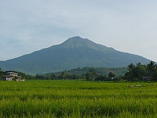
Kanlaon, also spelled as Kanla-on or sometimes Canlaon, is an active stratovolcano on the island of Negros, Philippines. It is the highest point in Negros, as well as the whole Visayas, with an elevation of 2,465 m (8,087 ft) above sea level.

Fourpeaked Mountain mountain

Fourpeaked Volcano is an active stratovolcano in Alaska. The Alaska Volcano Observatory rates Fourpeaked Volcano as Aviation Alert Level Green and Volcanic-alert Level Normal. It is nearly completely covered by Fourpeaked Glacier.

2009 Mount Redoubt eruptive activity

Alaska's Mount Redoubt volcano began erupting on March 22, 2009, and activity continued for several months.

Maritime impacts of volcanic eruptions

Less commonly publicized than the effects on aviation—and with less potential for catastrophe—maritime Impacts of volcanic eruptions are also dangerous. When a volcano erupts, large amounts of noxious gases, steam, rock, and ash are released into the atmosphere; fine ash can be transported thousands of miles from the volcano, while high concentrations of coarse particles fall out of the air near the volcano. The high concentrations of hazardous toxic gases are localized in the immediate vicinity of the volcano.

The National Volcano Early Warning and Monitoring System is a U.S. federal program within the U.S. Geological Survey for monitoring volcano activity and providing early warning to threatened areas. It was authorized by the John D. Dingell, Jr. Conservation, Management, and Recreation Act on March 12, 2019.

References