Wildey, Barbados

Last updated

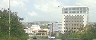
The Wildey area of the Parish of Saint Michael located roughly 4 km east of Bridgetown, it lies on the border with the Parish of Christ Church. Normally a very busy area with the ABC Highway, Wildey is one of the main convergence points for vehicles travelling either towards the capital-city Bridgetown or towards points in northern Barbados. In recent years the area was reconfigured for traffic mitigation, the tri-directional split or fork in the highway formerly known as the "Wildey Y" was changed to only allow southbound traffic to turn left or right on to Wildey Road only. Northbound traffic must now travel on Wildey Road to Highway R road which brings traffic back to BET hill.

Saint Michael, Barbados Parish in Barbados

The parish of St. Michael is one of eleven parishes of Barbados. It has a land area of 39 km2 and is found at the southwest portion of the island. Saint Michael has survived by name as one of the original six parishes created in 1629 by Governor Sir William Tufton.

Christ Church, Barbados Parish in Barbados

The parish of Christ Church is one of eleven historic political divisions of Barbados. It has a land area of 57 km2 (22 sq mi) and is found at the southern end of the island. Christ Church has survived by name as one of the original six parishes created in 1629 by Governor Sir William Tufton.

Bridgetown Capital city in Saint Michael, Barbados

Bridgetown is the capital and largest city of Barbados. Formerly The Town of Saint Michael, the Greater Bridgetown area is located within the parish of Saint Michael. Bridgetown is sometimes locally referred to as "The City", but the most common reference is simply "Town". As of 2014, its metropolitan population stands at roughly 110,000.

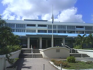
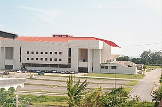
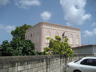
Buildings found in the immediate vicinity of Wildey include:

Coordinates: 13°06′N59°34′W / 13.100°N 59.567°W / 13.100; -59.567

Geographic coordinate system Coordinate system

A geographic coordinate system is a coordinate system that enables every location on Earth to be specified by a set of numbers, letters or symbols. The coordinates are often chosen such that one of the numbers represents a vertical position and two or three of the numbers represent a horizontal position; alternatively, a geographic position may be expressed in a combined three-dimensional Cartesian vector. A common choice of coordinates is latitude, longitude and elevation. To specify a location on a plane requires a map projection.


Related Research Articles

Transport in Barbados

Barbados is an up-and-coming tourist country that provides reliable and safe transportation for natives and visitors alike. The country is very small with a length of 21 miles (34 km) and a width of 14 miles (23 km). Barbados has 1,600 kilometres (990 mi) of public paved roads, two active marine ports in, remnants of a railway system, and one airport; the Sir Grantley Adams International Airport, located in Christ Church.

Holetown Town in Saint James, Barbados

Holetown, is a small town located in the Caribbean island nation of Barbados. Holetown is located in the parish of Saint James on the sheltered west coast of the island.

National Heroes Square Location in Bridgetown, Barbados

National Heroes Square, formerly Trafalgar Square, is located in Bridgetown, the capital and principal commercial centre of the island-nation of Barbados. The square lies along Upper Broad Street and is on the northern shore of the Careenage, found directly in the centre of Bridgetown.

Saint Lucy, Barbados Parish in Barbados

The parish of Saint Lucy is the northern-most area in the country of Barbados. Saint Lucy is the only parish of Barbados out of the eleven to be named after a female patron saint, Saint Lucy of Syracuse. Saint Lucy was the location of a United States Navy base at Harrison's Point. Saint Lucy's shape also resembles a peninsula, surrounded on three sides by the Atlantic Ocean to the north, east and west. The Harrison Point Lighthouse is located in Harrisons, Saint Lucy between Great Head and Norse's Bay, also in Saint Lucy. To the south lies the neighbouring Parish of Saint Peter.

Queen Elizabeth Hospital, Bridgetown

The Queen Elizabeth Hospital (Q.E.H.) is located in Barbados' capital city Bridgetown, which is located in the parish of Saint Michael. The hospital is the main General Hospital for the southern part of the island.

Cave Hill, Saint Michael, Barbados

Cave Hill, St. Michael is a suburban area situated in the parish of St. Michael. It is located about 4 km north-west of the capital city Bridgetown along the west coast of Barbados.

Foul Bay, Barbados

Foul Bay refers to a bay, beach, and village in Saint Philip Parish, alongside the southeast coast of Barbados.

The Sheraton Mall is a shopping and entertainment complex located close to the fringe of both Sargeants' Village and Vauxhall in the Parish of Christ Church, Barbados. The mall boasts having roughly 120 stores and services along with the only multiplex cinema on the island. The major anchor stores for the mall are Courts, DaCosta Mannings, and the Olympus Theatres cinema multiplex.

Diocese of Barbados

The Diocese of Barbados is one of eight dioceses of the Anglican Communion that is part of the Province of the West Indies.

Six Cross Roads was an old village in the Parish of Saint Philip in Barbados.

Warrens, Barbados Commercial Centre in Saint Michael, Barbados

The town of Warrens located in the parish of Saint Michael is one of the fastest developing areas in the country of Barbados. In the span of a few years beginning around the year 2000, the Warrens, Saint Michael area has become synonymous with new money flowing into the country and for the development in the form of newly constructed tall buildings.

Garfield Sobers Gymnasium

The Garfield Sobers Gymnasium is one of the main government-owned indoor sporting facilities located in the country of Barbados. Able to accommodate close to 5,000 people, it is situated northeast of the ABC Highway within the Sir Gary Sobers Sports Complex. Normally hosting many student, professional as well as charity sporting events to the wider Barbadian community, it has also become home to song contests, entertainment shows, basketball, volleyball, and bodybuilding events in addition to badminton contests. "The Gymnasium" is located in the neighbourhood of Wildey, Saint Michael. Also found at the Sir Gary Sobers Sports Complex are tennis courts and an Aquatic Centre. The Wildey Gymnasium was completed in November, 1992. In both 2005 and 2017 it underwent a sponsored refurbishment under grants by the Chinese government. In June 2017 a fire burned on the site located in some debris and refuse outside the main building during renovation construction.

Nidhe Israel Synagogue establishment in Bridgetown, Barbados

The Nidḥe Israel Synagogue is the only synagogue in Bridgetown, Barbados. It is one of the oldest synagogues in the Western hemisphere and a Barbados National Trust property. In 2011 the synagogue and excavated mikveh were designated as UNESCO protected properties within the World Heritage Site of Historic Bridgetown and its Garrison area.

ABC Highway highway in Barbados

The ABC Highway is the main urban highway in Barbados. Opened in 1989, it is named after three famous Barbadian politicians: John Michael Geoffrey Manningham ("Tom") Adams, Errol Barrow, and Hugh Gordon Cummins. From the east, the highway stretches from the Grantley Adams International Airport in Christ Church, to the western end at Cave Hill Road and University Drive, Cave Hill Campus, University of the West Indies, in Saint Michael. It roughly encircles the Parish of Saint Michael and wider metropolitan area of Bridgetown.

George Washington House (Barbados)

George Washington House in Barbados is a historic house where the future first U.S. President George Washington visited, in 1751. He was 19 years old at the time and traveling with his ailing half-brother, Lawrence Washington. In 2011, the property was designated as a UNESCO protected property within the World Heritage Site of Historic Bridgetown and its Garrison area.

Boscobelle is a populated place in the parish of Saint Peter, Barbados.

Barbados Railway Narrow-gauge railway

The Barbados Railway was a 38.6-kilometre (24.0 mi)-long narrow-gauge railway on Barbados with a gauge of initially 1,067 mm and later 762 mm. It had 98 bridges, very tight radii and a steep incline. It was used from 1883 to 1937, after it had gone several times through financial difficulties.