Lubstów is a village in the administrative district of Gmina Sompolno, within Konin County, Greater Poland Voivodeship, in west-central Poland. It lies approximately 7 kilometres (4 mi) south of Sompolno, 21 km (13 mi) north-east of Konin, and 107 km (66 mi) east of the regional capital Poznań.
Piaski is a village in the administrative district of Gmina Sompolno, within Konin County, Greater Poland Voivodeship, in west-central Poland. It lies approximately 14 kilometres (9 mi) north-west of Sompolno, 31 km (19 mi) north of Konin, and 98 km (61 mi) east of the regional capital Poznań.
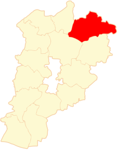
Boguszyce is a village in the administrative district of Gmina Wierzbinek, within Konin County, Greater Poland Voivodeship, in west-central Poland. It lies approximately 2 kilometres (1 mi) north of Wierzbinek, 31 km (19 mi) north-east of Konin, and 109 km (68 mi) east of the regional capital Poznań.
Broniszewo is a village in the administrative district of Gmina Wierzbinek, within Konin County, Greater Poland Voivodeship, in west-central Poland. It lies approximately 9 kilometres (6 mi) north-west of Wierzbinek, 30 km (19 mi) north of Konin, and 101 km (63 mi) east of the regional capital Poznań.
Kalina is a village in the administrative district of Gmina Wierzbinek, within Konin County, Greater Poland Voivodeship, in west-central Poland. It lies approximately 10 kilometres (6 mi) west of Wierzbinek, 28 km (17 mi) north of Konin, and 100 km (62 mi) east of the regional capital Poznań.
Kazimierowo is a village in the administrative district of Gmina Wierzbinek, within Konin County, Greater Poland Voivodeship, in west-central Poland. It lies approximately 7 kilometres (4 mi) north-west of Wierzbinek, 33 km (21 mi) north-east of Konin, and 106 km (66 mi) east of the regional capital Poznań.
Kryszkowice is a village in the administrative district of Gmina Wierzbinek, within Konin County, Greater Poland Voivodeship, in west-central Poland. It lies approximately 4 kilometres (2 mi) north of Wierzbinek, 32 km (20 mi) north-east of Konin, and 108 km (67 mi) east of the regional capital Poznań.
Mielno is a village in the administrative district of Gmina Wierzbinek, within Konin County, Greater Poland Voivodeship, in west-central Poland. It lies approximately 11 kilometres (7 mi) west of Wierzbinek, 24 km (15 mi) north of Konin, and 99 km (62 mi) east of the regional capital Poznań.
Noć is a village in the administrative district of Gmina Wierzbinek, within Konin County, Greater Poland Voivodeship, in west-central Poland. It lies approximately 8 kilometres (5 mi) west of Wierzbinek, 26 km (16 mi) north of Konin, and 101 km (63 mi) east of the regional capital Poznań.
Nykiel is a village in the administrative district of Gmina Wierzbinek, within Konin County, Greater Poland Voivodeship, in west-central Poland. It lies approximately 8 kilometres (5 mi) south-west of Wierzbinek, 22 km (14 mi) north-east of Konin, and 104 km (65 mi) east of the regional capital Poznań.
Obory is a village in the administrative district of Gmina Wierzbinek, within Konin County, Greater Poland Voivodeship, in west-central Poland. It lies approximately 10 kilometres (6 mi) west of Wierzbinek, 24 km (15 mi) north of Konin, and 100 km (62 mi) east of the regional capital Poznań.
Sadlno is a village in the administrative district of Gmina Wierzbinek, within Konin County, Greater Poland Voivodeship, in west-central Poland. It lies approximately 3 kilometres (2 mi) north-west of Wierzbinek, 30 km (19 mi) north-east of Konin, and 107 km (66 mi) east of the regional capital Poznań.
Słomkowo is a village in the administrative district of Gmina Wierzbinek, within Konin County, Greater Poland Voivodeship, in west-central Poland. It lies approximately 6 kilometres (4 mi) north-west of Wierzbinek, 31 km (19 mi) north-east of Konin, and 106 km (66 mi) east of the regional capital Poznań.
Stara Ruda is a village in the administrative district of Gmina Wierzbinek, within Konin County, Greater Poland Voivodeship, in west-central Poland. It lies approximately 9 kilometres (6 mi) south-west of Wierzbinek, 23 km (14 mi) north-east of Konin, and 101 km (63 mi) east of the regional capital Poznań.
Straszewo is a village in the administrative district of Gmina Wierzbinek, within Konin County, Greater Poland Voivodeship, in west-central Poland. It lies approximately 6 kilometres (4 mi) north-west of Wierzbinek, 31 km (19 mi) north-east of Konin, and 105 km (65 mi) east of the regional capital Poznań.
Synogać is a village in the administrative district of Gmina Wierzbinek, within Konin County, Greater Poland Voivodeship, in west-central Poland. It lies approximately 3 kilometres (2 mi) south-east of Wierzbinek, 29 km (18 mi) north-east of Konin, and 110 km (68 mi) east of the regional capital Poznań.
Tomisławice is a village in the administrative district of Gmina Wierzbinek, within Konin County, Greater Poland Voivodeship, in west-central Poland. It lies approximately 6 kilometres (4 mi) north of Wierzbinek, 34 km (21 mi) north-east of Konin, and 108 km (67 mi) east of the regional capital Poznań.
Witkowice is a village in the administrative district of Gmina Wierzbinek, within Konin County, Greater Poland Voivodeship, in west-central Poland. It lies approximately 6 kilometres (4 mi) north of Wierzbinek, 34 km (21 mi) north-east of Konin, and 107 km (66 mi) east of the regional capital Poznań.
Zielonka is a village in the administrative district of Gmina Wierzbinek, within Konin County, Greater Poland Voivodeship, in west-central Poland. It lies approximately 4 kilometres (2 mi) east of Wierzbinek, 32 km (20 mi) north-east of Konin, and 113 km (70 mi) east of the regional capital Poznań.
Ziemięcin is a village in the administrative district of Gmina Wierzbinek, within Konin County, Greater Poland Voivodeship, in west-central Poland. It lies approximately 3 kilometres (2 mi) north-west of Wierzbinek, 31 km (19 mi) north-east of Konin, and 108 km (67 mi) east of the regional capital Poznań.