
The Japan Trench is an oceanic trench part of the Pacific Ring of Fire off northeast Japan. It extends from the Kuril Islands to the northern end of the Izu Islands, and is 8,046 metres (26,398 ft) at its deepest. It links the Kuril–Kamchatka Trench to the north and the Izu–Ogasawara Trench to its south with a length of 800 kilometres (497 mi). This trench is created as the oceanic Pacific plate subducts beneath the continental Okhotsk Plate. The subduction process causes bending of the down going plate, creating a deep trench. Continuing movement on the subduction zone associated with the Japan Trench is one of the main causes of tsunamis and earthquakes in northern Japan, including the megathrust Tōhoku earthquake and resulting tsunami that occurred on 11 March 2011. The rate of subduction associated with the Japan Trench has been recorded at about 7.9–9.2 centimetres (3.1–3.6 in)/yr.
Megathrust earthquakes occur at convergent plate boundaries, where one tectonic plate is forced underneath another. The earthquakes are caused by slip along the thrust fault that forms the contact between the two plates. These interplate earthquakes are the planet's most powerful, with moment magnitudes (Mw) that can exceed 9.0. Since 1900, all earthquakes of magnitude 9.0 or greater have been megathrust earthquakes.

Many major earthquakes have occurred in the region of the Kamchatka Peninsula in far eastern Russia. Events in 1737, 1923 and 1952, were megathrust earthquakes and caused tsunamis. There are many more earthquakes and tsunamis originating from the region.
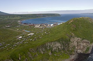
The 1952 Severo-Kurilsk earthquake struck off the coast of the Kamchatka Peninsula. The 9.0 Mw earthquake triggered a major tsunami that hit Severo-Kurilsk, Kuril Islands, Sakhalin Oblast, Russian SFSR, USSR, on 5 November 1952 at 04:58 local time. This led to the destruction of many settlements in Sakhalin Oblast and Kamchatka Oblast, while the main impact struck the town of Severo-Kurilsk. It was the most powerful earthquake ever recorded in Russia, and the fifth most powerful earthquake ever recorded in the world since modern seismography began in 1900.

The 1896 Sanriku earthquake was one of the most destructive seismic events in Japanese history. The 8.5 magnitude earthquake occurred at 19:32 on June 15, 1896, approximately 166 kilometres (103 mi) off the coast of Iwate Prefecture, Honshu. It resulted in two tsunami waves which destroyed about 9,000 homes and caused at least 22,000 deaths. The waves reached a then-record height of 38.2 metres (125 ft); this would remain the highest on record until waves from the 2011 Tōhoku earthquake exceeded that height by more than 2 metres.

The 1707 Hōei earthquake struck south-central Japan at 14:00 local time on 28 October. It was the largest earthquake in Japanese history until it was surpassed by the 2011 Tōhoku earthquake. It caused moderate-to-severe damage throughout southwestern Honshu, Shikoku and southeastern Kyūshū. The earthquake, and the resulting destructive tsunami, caused more than 5,000 casualties. This event ruptured all of the segments of the Nankai megathrust simultaneously, the only earthquake known to have done this, with an estimated magnitude of 8.6 or 8.7 . It possibly also triggered the last eruption of Mount Fuji 49 days later.

The 1978 Miyagi earthquake occurred at 17:14 local time on 12 June. The epicentre was offshore of Miyagi Prefecture, Japan. It had a surface wave magnitude of 7.7, JMA magnitude 7.4, and triggered a small tsunami. The earthquake reached a maximum intensity of Shindo 5 in Sendai and caused 28 deaths and 1,325 injuries.
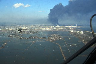
On 11 March 2011, at 14:46 JST, a 9.0–9.1 undersea megathrust earthquake occurred in the Pacific Ocean, 72 km (45 mi) east of the Oshika Peninsula of the Tōhoku region. It lasted approximately six minutes, causing a tsunami. It is sometimes known in Japan as the "Great East Japan Earthquake", among other names. The disaster is often referred to by its numerical date, 3.11.
The 869 Jōgan earthquake and its associated tsunami struck the area around Sendai in the northern part of Honshu on 13 July 869. The earthquake had an estimated magnitude of at least 8.4 on the moment magnitude scale, but may have been as high as 9.0, similar to the 2011 Tōhoku earthquake and tsunami. The tsunami caused widespread flooding of the Sendai plain. In 2001, researchers identified sand deposits in a trench more than 4.5 kilometres (2.8 mi) from the coast as coming from this tsunami.

The 1994 offshore Sanriku earthquake occurred on December 28, 1994, at 12:19 UTC. This was a magnitude 7.7 earthquake with epicenter located in the Pacific Ocean at about 180 km east of Hachinohe, Aomori. The intensity reached shindo 6 in Hachinohe, Aomori, about 187.6 km from epicenter. It could be felt in Tokyo, about 632.9 km from epicenter, with shindo 2. The Japanese Meteorological Agency put the magnitude at 7.5. Slip associated with this earthquake continued for more than a year and it has been termed an 'ultra-slow earthquake'.
The 1605 Keichō earthquake occurred at about 20:00 local time on 3 February. It had an estimated magnitude of 7.9 on the surface wave magnitude scale and triggered a devastating tsunami that resulted in thousands of deaths in the Nankai and Tōkai regions of Japan. It is uncertain whether there were two separate earthquakes separated by a short time interval or a single event. It is referred to as a tsunami earthquake, in that the size of the tsunami greatly exceeds that expected from the magnitude of the earthquake.

In seismology, a tsunami earthquake is an earthquake which triggers a tsunami of significantly greater magnitude, as measured by shorter-period seismic waves. The term was introduced by Japanese seismologist Hiroo Kanamori in 1972. Such events are a result of relatively slow rupture velocities. They are particularly dangerous as a large tsunami may arrive at a coastline with little or no warning.
The 1611 Sanriku earthquake occurred on December 2, 1611, with an epicenter off the Sanriku coast in Iwate Prefecture, Japan. The magnitude of the earthquake was 8.1. It triggered a devastating tsunami. A description of this event in an official diary from 1612 is probably the first recorded use of the term 'tsunami'.

A tsunami deposit is a sedimentary unit deposited as the result of a tsunami. Such deposits may be left onshore during the inundation phase or offshore during the 'backwash' phase. Such deposits are used to identify past tsunami events and thereby better constrain estimates of both earthquake and tsunami hazards. There remain considerable problems, however, in distinguishing between deposits caused by tsunamis and those caused by storms or other sedimentary processes.
The Nemuro-Oki earthquake in scientific literature, occurred on June 17 at 12:55 local time. It struck with an epicenter just off the Nemuro Peninsula in northern Hokkaidō, Japan. It measured 7.8–7.9 on the moment magnitude scale (Mw ), 8.1 on the tsunami magnitude scale (Mt ) and 7.4 on the Japan Meteorological Agency magnitude scale (MJMA ).
On April 13, 1923 at 15:31 UTC, an earthquake occurred off the northern coast of the Kamchatka Peninsula in the USSR, present-day Russia. The earthquake had a surface-wave magnitude (Ms ) of 6.8–7.3 and an estimated moment magnitude (Mw ) of 7.0–8.2. This event came just two months after a slightly larger earthquake with an epicenter struck south of the April event. Both earthquakes were tsunamigenic although the latter generated wave heights far exceeding that of the one in February. After two foreshocks of "moderate force", the main event caused considerable damage. Most of the 36 casualties were the result of the tsunami inundation rather than the earthquake.

The 1585 Aleutian Islands earthquake is the presumed source of a tsunami along the Sanriku coast of Japan on 11 June 1585, known only from vague historical accounts and oral traditions. The event was initially misdated to 1586, which led to it being associated with the deadly earthquakes in Peru and Japan of that year. A megathrust earthquake on the Aleutian subduction zone in the North Pacific Ocean was hypothesized as the tsunami's source. Paleotsunami evidence from shoreline deposits and coral rocks in Hawaii suggest that the 1585 event was a large megathrust earthquake with a moment magnitude (Mw ) as large as 9.25.

An earthquake occurred off the coast of the Alaska Peninsula on July 28, 2021, at 10:15 p.m. local time. The large megathrust earthquake had a moment magnitude of 8.2 according to the United States Geological Survey (USGS). A tsunami warning was issued by the National Oceanic and Atmospheric Administration (NOAA) but later cancelled. The mainshock was followed by a number of aftershocks, including three that were of magnitude 5.9, 6.1 and 6.9 respectively.
The 1586 Lima–Callao earthquake occurred on July 9 along the coast of Peru, near the capital Lima. A section of the Peruvian coast, stretching from Caravelí to Trujillo, north to south, was severely damaged by the earthquake. Major destruction occurred in the capital city Lima as well. The estimated moment magnitude (Mw ) 8.1 earthquake triggered a locally damaging tsunami up to 5 m (16 ft). This was the first major earthquake to strike the city of Lima since its establishment in 1535.

The 1940 Shakotan earthquake occurred on August 2 at 00:08:22 JST with a moment magnitude (Mw ) of 7.5 and maximum JMA seismic intensity of Shindo 4. The shock had an epicenter off the coast of Hokkaido, Japan. Damage from the shock was comparatively light, but the accomanying tsunami was destructive. The tsunami caused 10 deaths and 24 injuries on Hokkaido, and destroyed homes and boats across the Sea of Japan. The highest tsunami waves were recorded at the coast of Russia while along the coast of Hokkaido, waves were about 2 m.
