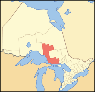
Route 31 is a state highway in New Jersey, United States. It runs 48.93 mi (78.75 km) from U.S. Route 1 Business /US 206 in Trenton, Mercer County, north to an intersection with US 46 in Buttzville in White Township, Warren County. Along the way, Route 31 heads through the communities of Flemington, Clinton and Washington. Most of the highway is state-maintained; however, the section within the city limits of Trenton is maintained by the city. Much of Route 31 is a two-lane highway that passes through farmland, woodland, and mountainous areas. Two portions of the route—from Trenton to Pennington and from Ringoes to Clinton—consist of more development.
County Route 583, abbreviated CR 583, is a county highway in the U.S. state of New Jersey. Its northern end is at an intersection with Route 27 in Princeton; its southern end is in a concurrency with U.S. Route 1 Business and U.S. Route 206 at an intersection with County Route 653 in Trenton.

U.S. Route 92 is a 181-mile (291 km.) intrastate U.S. Route in the U.S. state of Florida. The western terminus is at US 19 Alt. and SR 687 in downtown St. Petersburg. The eastern terminus is at SR A1A in Daytona Beach.
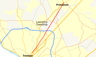
County Route 546, abbreviated CR 546, is a county highway in the U.S. state of New Jersey. The highway begins at Route 29 within the Titusville, New Jersey section of Hopewell Township and extends 9.98 miles (16.06 km) to U.S. Route 1 (US 1) in Lawrence Township. The road runs entirely within Mercer County.

New York State Route 249 (NY 249) is a 13.50-mile (21.73 km) long state highway located within Erie County, New York, in the United States. It runs east–west across southwestern Erie County from the shores of Lake Erie in the village of Farnham to the hamlet of Langford in the town of North Collins. The route was designated as NY 249 in the 1930 renumbering of state highways in New York from Farnham to the village of North Collins. By the next year, the route was extended to its current length.

New York State Route 106 (NY 106) is a 13.28-mile (21.37 km) state highway located in Nassau County, New York, in the United States. It begins in the town of Hempstead at an intersection with NY 105 in North Bellmore and heads to the north, crossing the hamlets of East Meadow and Levittown before entering the town of Oyster Bay. In Hicksville, NY 106 becomes concurrent with NY 107, an overlap colloquially known as the "One oh Six–One oh Seven". The concurrency ends immediately after an interchange with Jericho Turnpike in the hamlet of Jericho. After breaking away from NY 107, NY 106 heads north across the villages of Brookville and Muttontown and the hamlet of East Norwich to the hamlet of Oyster Bay, where the route ends one block south of Oyster Bay Harbor.
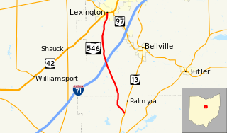
State Route 546 is a north–south state highway in the northern portion of the U.S. state of Ohio. The southern terminus of SR 546 is at a T-intersection with SR 13 nearly two and a half miles (4.0 km) north of Fredericktown. Its northern terminus is at a signalized intersection with the U.S. Route 42 (US 42)/SR 97 concurrency in Lexington.

New York State Route 914T (NY 914T) is an unsigned reference route designation for the portion of Balltown Road south of Union Street in Schenectady, New York, in the United States. The route is a short two-lane highway just east of the city limits, running from NY 5 to its intersection with Union Street where NY 146 meets. East of Balltown Road, Union Street is maintained by the New York State Department of Transportation as unsigned NY 911G; however, there are no markers to this effect. Balltown Road is nearly north–south with very few turns. It eventually reaches the town of Ballston in Saratoga County.
The New York State Department of Transportation (NYSDOT) is responsible for the establishment and classification of a state highway network which includes Interstate Highways, U.S. Highways, and state routes. U.S. and Interstate Highways are classified as state routes in New York; however, a letter is suffixed to the number of the route. As a result, there is apparent duplication between U.S. Routes, Interstate Highways and state routes.
State Route 546 (SR 546) is a state highway in Whatcom County, Washington, United States. It runs east–west for 8 miles (13 km) near the Canadian border, connecting SR 539 near Lynden to SR 9 near Nooksack and Sumas. The highway is a major freight corridor and serves as an alternate route between Bellingham and the Sumas border crossing.

Pennsylvania Route 346 (PA 346) is a 34.177-mile (55.003 km) state highway located in Warren and McKean counties in Pennsylvania, United States The western terminus is at the New York state line in the Allegheny National Forest, where it becomes New York State Route 280 (NY 280). The eastern terminus is at an intersection with PA 446 in Eldred. The route is mostly a two-lane road that passes through rural areas in the northern part of McKean County. PA 346 passes through the city of Bradford, where it has a concurrency with the U.S. Route 219 (US 219) freeway.
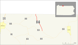
Pennsylvania Route 546 is an 3.586-mile-long (5.771 km) state highway in the northernmost regions of McKean County, Pennsylvania. The route, known locally as Oil Valley Road, begins at an intersection with PA 346 in the community of Duke Center. The highway heads northward, through mountainous regions before crossing the state line and into New York, where it continues as Duke Center Road to New York State Route 16.
Spur 117 is a 0.546-mile-long (879 m) spur route in the U.S. state of Texas that connects Interstate 410 (I-410) and Loop 13 in San Antonio in Bexar County. The road is maintained by the Texas Department of Transportation (TxDOT). The spur was designated in 1980 and follows W.W. White Road from I-410 on the southeast side of San Antonio towards the northwest ending at Loop 13.
U.S. Route 40 Alternate is the U.S. Highway designation for a former segment of U.S. Route 40 (US 40) through Garrett and Allegany counties in Maryland. The highway begins at US 40 near exit 14 on Interstate 68 (I-68) and runs 31.80 miles (51.18 km) eastward to Cumberland, where it ends at exit 44 on I-68. Alt US 40 is maintained by the Maryland State Highway Administration (MDSHA).
Kentucky Route 202 (KY 202) is a 10.281-mile-long (16.546 km) state highway in Kentucky that runs from U.S. Route 421 (US 421) and KY 55 north of New Castle to KY 389 in rural Henry County northwest of Gratz.
State Road 546 (SR 546) is a 5.837-mile-long (9.394 km) state highway in Lakeland, Polk County, Florida, that runs from Interstate 4 to U.S. Route 92 and Florida State Road 600. SR 546 is only signed for the first 1.731 miles (2.786 km), after which it is concurrent with US 92.