
Hallstatt is a small town in the district of Gmunden, in the Austrian state of Upper Austria. Situated between the southwestern shore of Hallstätter See and the steep slopes of the Dachstein massif, the town lies in the Salzkammergut region, on the national road linking Salzburg and Graz.
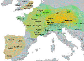
The Hallstatt culture was the predominant Western and Central European culture of Late Bronze Age from the 12th to 8th centuries BC and Early Iron Age Europe from the 8th to 6th centuries BC, developing out of the Urnfield culture of the 12th century BC and followed in much of its area by the La Tène culture. It is commonly associated with Proto-Celtic populations. Older assumptions of the early 20th century of Illyrians having been the bearers of especially the Eastern Hallstatt culture are indefensible and archeologically unsubstantiated.
The Salzkammergut is a resort area in Austria, stretching from the city of Salzburg eastwards along the Alpine Foreland and the Northern Limestone Alps to the peaks of the Dachstein Mountains. The main river of the region is the Traun, a right tributary of the Danube.

The Northern Limestone Alps, also called the Northern Calcareous Alps, are the ranges of the Eastern Alps north of the Central Eastern Alps located in Austria and the adjacent Bavarian lands of southeastern Germany. The distinction from the latter group, where the higher peaks are located, is based on differences in geological composition.

Hoher Dachstein is a strongly karstic mountain in central Austria and the second-highest mountain in the Northern Limestone Alps. It is situated at the border of Upper Austria and Styria, and is the highest point in each of those states. Parts of the massif also lie in the state of Salzburg, leading to the mountain being referred to as the Drei-Länder-Berg.

Magnus Hovdal Moan is a retired Norwegian Nordic combined skier who has competed since 2002 until 2019.

Ramsau am Dachstein is a municipality in the district of Liezen, state of Styria, Austria. It is also the name of the elevated plateau between the Dachstein range and the Enns valley on which this municipality is located.

Altaussee is a municipality and spa town in the district of Liezen in Styria, Austria. The small village is nestled on the shores of the Lake Altaussee, beneath the Loser Plateau. Occupying an area of 92 km², Altaussee is home to 1,777 people. The municipality includes two cadastral communities: Altaussee and Lupitsch. The designated climatic spa is within the Salzkammergut region. Altaussee has the biggest salt deposits of Austria, which are still mined today.

Pyramidenkogel is an 851-metre-high (2,792 ft) mountain in Carinthia, Austria. It is located to the south of the Wörthersee and near the town of Maria Wörth, in an area that is a boundary between speakers of German and Slovenian. In nearby Slovenia the mountain is known as Jedvovca. The mountain has been a tourist attraction since at least the late 19th century. The view from its top is mentioned in Karl Baedeker's 1879 The Eastern Alps.

Obertraun, Upper Austria is a village in the Salzkammergut, a region in Austria, near the Hallstätter See and Hoher Dachstein. It is a popular holiday destination with activities such as skiing and snowboarding in the winter, and mountain biking, swimming and kayaking in the summer.

Gosau is a municipality in the district of Gmunden in Upper Austria, Austria.

Dachstein Glacier is a glacier located between the towns of Ramsau am Dachstein in the south and Hallstatt and Obertraun in the north, in Austria. Snow is at the top of the glacier throughout the year. However snow is soft in summer. This mountain is located at the borders of Salzburg, Upper Austria and Styria. The train stops at Schladming and from there is a bus to the village below the Dachstein Mountains.

The Salzkammergut Mountains are a mountain range of the Northern Limestone Alps, located in the Austrian states of Salzburg and Upper Austria. They are named after the Salzkammergut historic region, part of the Hallstatt-Dachstein / Salzkammergut Cultural Landscape UNESCO World Heritage Site.

The Dachstein Chapel is located immediately next to the Simony Hut in the Dachstein Mountains. It lies at a height of 2,206 m and is the highest place of worship in the Northern Limestone Alps. It is located within the municipality area of Hallstatt in the district of Gmunden in Austria. It belongs to the Roman Catholic Diocese of Linz and is a cultural heritage monument.

The Simony Hut is an Alpine club hut belonging to the Austrian Alpine Club (OeAV) located at a height of 2,205 metres, just below the Hallstätter Glacier at the foot of the Hoher Dachstein in Austria. The hut, which is named after Friedrich Simony the first person to ascend Hoher Dachstein, is high above Hallstatt in Upper Austria in the northern part of the Dachstein Mountains. It is open year-round and, in winter, offers numerous options for ski tours and snowshoe walking.

The Grimming is an isolated peak in the Dachstein Mountains of Austria and one of the few ultra-prominent mountains of the Alps.

A double summit, double peak, twin summit, or twin peak refers to a mountain or hill that has two summits, separated by a col or saddle.

The Gosaukamm is an Austrian mountain chain within the Dachstein range of the Northern Limestone Alps. Although relatively short in length, the chain forms an imposing backdrop to the valley and town of Gosau. Its highest point reaches an elevation of 2,458 metres (8,064 ft).

The Große Bischofsmütze is the highest peak in the Gosaukamm range of the Dachstein Mountains, Austria.
