62 Pompeii earthquake

Last updated
62 Pompeii earthquake
Italy relief location map.jpg
Bullseye1.png
Local date5 February 62 (2062-02-05)
Magnitude5.2–6.1
Epicenter 40°42′N14°30′E / 40.7°N 14.5°E / 40.7; 14.5 Coordinates: 40°42′N14°30′E / 40.7°N 14.5°E / 40.7; 14.5 [1]
Areas affected Roman Empire, Campania
Max. intensity IX–X

The 62 Pompeii earthquake occurred on 5 February 62 AD. It had an estimated magnitude of between 5 and 6 and a maximum intensity of IX or X on the Mercalli intensity scale. The towns of Pompeii and Herculaneum were severely damaged. The earthquake may have been a precursor to the eruption of Mount Vesuvius in AD 79, which destroyed the same two towns. The contemporary philosopher and dramatist Seneca the Younger wrote an account of the earthquake in the sixth book of his Naturales quaestiones , entitled De Terrae Motu (Concerning Earthquakes).

Pompeii Ancient Roman city near modern Naples, Italy

Pompeii was an ancient Roman city located in the modern comune of Pompei near Naples in the Campania region of Italy. Pompeii, along with Herculaneum and many villas in the surrounding area, was buried under 4 to 6 m of volcanic ash and pumice in the eruption of Mount Vesuvius in AD 79.

Herculaneum Roman town destroyed by eruption of Mount Vesuvius

Located in the shadow of Mount Vesuvius, Herculaneum was an ancient Roman town destroyed by volcanic pyroclastic flows in 79 AD. Its ruins are located in the comune of Ercolano, Campania, Italy.

Eruption of Mount Vesuvius in 79 Volcanic eruption in the Roman Empire

Mount Vesuvius, a stratovolcano in modern-day Italy, erupted in 79 AD in one of the deadliest volcanic eruptions in European history, which was witnessed and documented by Pliny the Younger, a Roman administrator and poet.

Contents

Geological setting

The epicentre of the earthquake lies within a zone of active extensional faulting, but close to the southern flank of Vesuvius. Analysis of focal mechanisms from the area around Vesuvius indicates that active faulting in the area involves NW–SE and NE–SW trending oblique-slip normal faults and E–W trending normal faults, part of the zone of active extension that extends the full length of the Apennines mountain chain, associated with continued opening of the Tyrrhenian Sea. [2] An association between earthquakes in the central Apennines and eruptions of Vesuvius has been proposed, but is not yet proven. [3]

Focal mechanism

The focal mechanism of an earthquake describes the deformation in the source region that generates the seismic waves. In the case of a fault-related event it refers to the orientation of the fault plane that slipped and the slip vector and is also known as a fault-plane solution. Focal mechanisms are derived from a solution of the moment tensor for the earthquake, which itself is estimated by an analysis of observed seismic waveforms. The focal mechanism can be derived from observing the pattern of "first motions", that is, whether the first arriving P waves break up or down. This method was used before waveforms were recorded and analysed digitally and this method is still used for earthquakes too small for easy moment tensor solution. Focal mechanisms are now mainly derived using semi-automatic analysis of the recorded waveforms.

Tyrrhenian Sea Part of the Mediterranean Sea off the western coast of Italy

The Tyrrhenian Sea is part of the Mediterranean Sea off the western coast of Italy. It is named for the Tyrrhenian people, identified since the 6th century BCE with the Etruscans of Italy.

Characteristics

The extent of damage has been used to estimate the magnitude of the earthquake. Estimates lie in the range from about 5 to 6.1. [4] The maximum felt intensity is estimated to have been in the range IX to X, [1] [5] and the area of highest intensity was elongated roughly WNW–ESE. [5] Shaking was reported to have continued for several days, [6] presumably referring to a sequence of aftershocks. The focal depth is estimated to have been in the range 5–6 km. [7]

An aftershock is a smaller earthquake that follows a larger earthquake, in the same area of the main shock, caused as the displaced crust adjusts to the effects of the main shock. Large earthquakes can have hundreds to thousands of instrumentally detectable aftershocks, which steadily decrease in magnitude and frequency according to known laws. In some earthquakes the main rupture happens in two or more steps, resulting in multiple main shocks. These are known as doublet earthquakes, and in general can be distinguished from aftershocks in having similar magnitudes and nearly identical seismic waveforms.

Hypocenter site of an earthquake or a nuclear explosion

A hypocenter is the point of origin of an earthquake or a subsurface nuclear explosion. In seismology, it is a synonym of the focus. The term hypocenter is also used as a synonym for ground zero, the surface point directly beneath a nuclear airburst.

Damage

The towns of Pompeii and Herculaneum both suffered major damage, with damage to some buildings also reported from Naples and Nuceria. [5] Seneca reported the death of a flock of 600 sheep that he attributed to the effects of poisonous gases. [6]

Naples Comune in Campania, Italy

Naples is the regional capital of Campania and the third-largest municipality in Italy after Rome and Milan. In 2017, around 967,069 people lived within the city's administrative limits while its province-level municipality has a population of 3,115,320 residents. Its continuously built-up metropolitan area is the second or third largest metropolitan area in Italy and one of the most densely populated cities in Europe.

Nocera Inferiore Comune in Campania, Italy

Nocera Inferiore is a city and comune in Campania, Italy, in the province of Salerno, at the foot of Monte Albino, 20 kilometres (12 mi) east-south-east of Naples by rail.

Aftermath

The damage caused by the mainshock and the subsequent series of tremors was at least partly repaired in both Pompeii and Herculaneum by the time of the AD 79 eruption. A pair of bas-reliefs, probably from the lararium in the house of Lucius Caecilius Iucundus in Pompeii, are interpreted as depicting the effects of the earthquake on structures including the Temple of Jupiter, the Aquarium of Cesar, and the Vesuvius Gate. [8]

Lares Familiares

Lares Familiares were household tutelary deities of ancient Roman religion. The singular form is Lar Familiaris.

Lucius Caecilius Iucundus Ancient Roman Banker

Lucius Caecilius Iucundus was a banker who lived in the Roman town of Pompeii around 14 A.D.–62 A.D. His house still stands and can be seen in the ruins of the city of Pompeii which remain after being partially destroyed by the eruption of Vesuvius in 79 AD. This house is known for its beauty, along with some material found about bank book-keeping and wax tablets, which were receipts. He is well known for being a central character in the Cambridge Latin Course series.

Temple of Jupiter (Pompeii)

The Temple of Jupiter, Capitolium, or Temple of the Capitoline Triad was a temple in Roman Pompeii, at the north end of its forum. Initially dedicated to Jupiter alone, it was built in the mid-2nd century BC at the same time as the temple of Apollo was being renovated - this was the area at which Roman influence over Pompeii increased and so Roman Jupiter superseded the Greek Apollo as the town's highest god. Jupiter was the ruler of the gods and the protector of Rome, where his temple was the center of Roman Religion and of the cult of state.

The earthquake led Roman philosopher, statesman and dramatist Seneca the Younger to devote the sixth book of his Naturales quaestiones to the subject of earthquakes, describing the event of 5 February and giving the cause of earthquakes as the movement of air. [6]

Seneca the Younger Roman Stoic philosopher, statesman, and dramatist

Seneca the Younger(c. 4 BC – AD 65), fully Lucius Annaeus Seneca and also known simply as Seneca, was a Roman Stoic philosopher, statesman, dramatist, and—in one work—satirist of the Silver Age of Latin literature.

See also

Related Research Articles

Supervolcano Volcano that has erupted 1000 cubic km in a single eruption

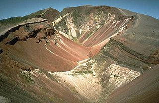
A supervolcano is a large volcano that has had an eruption with a Volcanic Explosivity Index (VEI) of 8, the largest recorded value on the index. This means the volume of deposits for that eruption is greater than 1,000 cubic kilometers.

Mount Vesuvius Stratovolcano in the Gulf of Naples, Italy

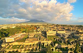
Mount Vesuvius is a somma-stratovolcano located on the Gulf of Naples in Campania, Italy, about 9 km (5.6 mi) east of Naples and a short distance from the shore. It is one of several volcanoes which form the Campanian volcanic arc. Vesuvius consists of a large cone partially encircled by the steep rim of a summit caldera caused by the collapse of an earlier and originally much higher structure.

Bradyseism

Bradyseism is the gradual uplift or descent of part of the Earth's surface caused by the filling or emptying of an underground magma chamber and/or hydrothermal activity, particularly in volcanic calderas. It can persist for millennia in between eruptions and each uplift event is normally accompanied by thousands of small to moderate earthquakes. The word derives from the ancient Greek words "bradus", meaning 'slow', and "seism" meaning 'movement', and was coined by Arturo Issel in 1883.

Mount Tarawera mountain

Mount Tarawera is the volcano responsible for one of New Zealand's largest historic eruptions. Located 24 kilometres southeast of Rotorua in the North Island, it consists of a series of rhyolitic lava domes that were fissured down the middle by an explosive basaltic eruption in 1886, which killed an estimated 120 people. These fissures run for about 17 kilometres northeast-southwest.

Volcano tectonic earthquake

A volcano tectonic earthquake is an earthquake induced by the movement of magma. The movement results in pressure changes in the rock around where the magma has experienced stress. At some point, the rock may break or move. The earthquakes may also be related to dike intrusion and may occur as earthquake swarms. An example is the 2007–2008 Nazko earthquake swarm in central British Columbia, Canada.

Galeras Volcanic mountain in Colombia

Galeras is an Andean stratovolcano in the Colombian department of Nariño, near the departmental capital Pasto. Its summit rises 4,276 metres (14,029 ft) above sea level. It has erupted frequently since the Spanish conquest, with its first historical eruption being recorded on December 7, 1580. A 1993 eruption killed nine people, including six scientists who had descended into the volcano's crater to sample gases and take gravity measurements in an attempt to be able to predict future eruptions. It is currently the most active volcano in Colombia.

Porak mountain in Azerbaijan

Porak or Axarbaxar is a stratovolcano located in the Vardenis volcanic ridge. It lies about 20 km (12 mi) southeast of Lake Sevan and the volcanic field spans the border between Armenia and Azerbaijan (NKR) with lava flows running into both countries. Ten satellite cones and fissure vents lie on the flanks of the volcano.

Morne Diablotins Mountain in Dominica in the Lesser Antilles

Morne Diablotins is the highest mountain in Dominica, an island-nation in the Caribbean Lesser Antilles. It is the second highest mountain in the Lesser Antilles, after La Grande Soufrière in Guadeloupe. Morne Diablotins is located in the northern interior of the island, about 15 miles north of Dominica's capital Roseau and about 6 miles southeast of Portsmouth, the island's second-largest town. It is located within Morne Diablotin National Park.

George Patrick Leonard Walker was a British geologist who specialized in mineralogy and volcanology.

Mount Hasan mountain in Aksaray, Turkey

Mount Hasan is a volcano in Anatolia, Turkey. It has two summits, the 3,069 metres (10,069 ft) high eastern Small Hasan Dagi and the 3,253 metres (10,673 ft) high Big Hasan Dagi, and rises about 1 kilometre (0.62 mi) above the surrounding terrain. It consists of various volcanic deposits, including several calderas, and its activity has been related to the presence of several faults in the area and to regional tectonics.

Somma Vesuviana Comune in Campania, Italy

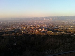
Somma Vesuviana is a town and comune in the Metropolitan City of Naples, Campania, southern Italy.

Laguna de Ayarza

Laguna de Ayarza is a crater lake in Guatemala. The lake is a caldera that was created some 20,000 years ago by a catastrophic eruption that destroyed a twinned volcano and blanketed the entire region with a layer of pumice. The lake has a surface area of 14 km² and a maximum depth of 230 m. The lake has a surface elevation of 1409 m.

1703 Apennine earthquakes

The 1703 Apennine earthquakes were a sequence of three earthquakes of magnitude ≥6 that occurred in the central Apennines of Italy, over a period of 19 days. The epicenters were near Norcia, Montereale and L'Aquila, showing a southwards progression over about 36 km. These events involved all of the known active faults between Norcia and L'Aquila. A total of about 10,000 people are estimated to have died as a result of these earthquakes, although because of the overlap in areas affected by the three events, casualty numbers remain highly uncertain.

The magma supply rate measures the production rate of magma at a volcano. Global magma production rates on Earth are about 20–25 cubic kilometres per year (4.8–6.0 cu mi/a).

Dispersal index is a parameter in volcanology. The dispersal index was defined by George P. L. Walker in 1973 as the surface area covered by an ash or tephra fall, where the thickness is equal or more than 1/100 of the thickness of the fall at the vent. An eruption with a low dispersal index leaves most of its products close to the vent, forming a cone; an eruption with a high dispersal index forms thinner sheet-like deposits which extends to larger distances from the vent. A dispersal index of 500 square kilometres (190 sq mi) or more of coarse pumice is one proposed definition of a Plinian eruption. Likewise, a dispersal index of 50,000 square kilometres (19,000 sq mi) has been proposed as a cutoff for an ultraplinian eruption. The definition of 1/100 of the near-vent thickness was partially dictated by the fact that most tephra deposits are not well preserved at larger distances.

The geology of Martinique originated from volcanic eruptions, but has different rocks than nearby Lesser Antilles volcanic island arc islands all of which formed in the last 40 million years in the Cenozoic. A high-alumina basalt ranges from olivine basalt to tridymite-rich dacite. Calc-alkaline volcanic rocks are rich in hornblende and orthpyroxene andesite, hornblende andesite and quartz-hornblende dacite are also common. Mount Pelee is one of the most active Caribbean volcanoes with 20 eruptions in the last 5000 years. It also heats groundwater, generating hydrothermal eruptions at sulfur springs in 1751 and 1851.

References

  1. 1 2 NGDC. "Comments for the Significant Earthquake" . Retrieved 29 April 2011.
  2. "Magnitude 6.3 – CENTRAL ITALY 2009 April 06 01:32:42 UTC". USGS. 6 April 2009. Archived from the original on January 6, 2010. Retrieved 30 April 2011.
  3. Marzocchi, W.; Scandone R. & Mulargia F. (1993). "The tectonic setting of Mount Vesuvius and the correlation between its eruptions and the earthquakes of the Southern Apennines". Journal of Volcanology and Geothermal Research. 58 (1–4): 27–41. Bibcode:1993JVGR...58...27M. doi:10.1016/0377-0273(93)90100-6.
  4. Cubellis, E.; Marturano A. (2002). "Mt. Vesuvius: a macroseismic study of the earthquake of 9 October 1999". Journal of Volcanology and Geothermal Research. 118 (3–4): 339–351. Bibcode:2002JVGR..118..339C. doi:10.1016/S0377-0273(02)00301-3.
  5. 1 2 3 Cubellis, E.; Luongo G. & Marturano A. (2007). "Seismic hazard assessment at Mt. Vesuvius: Maximum expected magnitude". Journal of Volcanology and Geothermal Research. 162 (3–4): 139–148. Bibcode:2007JVGR..162..139C. doi:10.1016/j.jvolgeores.2007.03.003.
  6. 1 2 3 Seneca. Naturales quaestiones. VI De Terrae Motu. Retrieved 29 April 2011.
  7. De Carolis, E.; Patricelli, G. (2003). Vesuvius, A.D. 79: The Destruction of Pompeii and Herculaneum. L'Erma di Bretschneider. pp. 71–76. ISBN   978-88-8265-199-2 . Retrieved 29 April 2011.
  8. Cooley, A.; Cooley, M.G.L. (2004). Pompeii: a sourcebook. Routledge Sourcebooks for the Ancient World Series. Routledge. pp. 28–31. ISBN   978-0-415-26211-8 . Retrieved 29 April 2011.