Bambalapitiya is a neighbourhood of Colombo, Sri Lanka. The area, numbered Colombo 4, spans about one and a half kilometres of the Galle Road. The western suburb is bordered by the Indian Ocean. The neighbourhood is bordered to the east by Havelock Town, to the north by Kollupitiya, and to the south by Wellawatte.

Velanai is a small village in Velanai Island off the coast of Jaffna Peninsula in the North of Sri Lanka.

Kelaniya is a suburb of Colombo city in Western Province, Sri Lanka. It is known for the Buddhist temple built on the banks of the Kelani River, which runs through the suburb. It is also a religious center for veneration of the figures, Vibhishana and Guanyin.

Ceylon was a British Crown colony between 1815 and 1948. Initially the area it covered did not include the Kingdom of Kandy, which was a protectorate from 1815, but from 1817 to 1948 the British possessions included the whole island of Ceylon, now the nation of Sri Lanka.
National Library and Documentation Services Board is the agency of the government of Sri Lanka which helps maintains all state libraries around the country including the Colombo Library but the management of individual libraries in cities and towns are carried out by the Municipal Council.
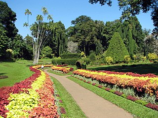
Royal Botanic Gardens, Peradeniya are about 5.5 km to the west of the city of Kandy in the Central Province of Sri Lanka. It attracts 2 million visitors annually. It is near the Mahaweli River. It is renowned for its collection of orchids. The garden includes more than 4000 species of plants, including orchids, spices, medicinal plants and palm trees. Attached to it is the National Herbarium of Sri Lanka. The total area of the botanical garden is 147 acres (0.59 km2), at 460 meters above sea level, and with a 200-day annual rainfall. It is managed by the Division of National Botanic Gardens of the Department of Agriculture.

Thalawathugoda is a suburb of Colombo city. It is located approximately sixteen (16) kilometres from the city centre of Colombo, adjacent to Battaramulla and Pelawatte on the Borella-Kottawa main road, bordering Sri Jayawardenapura-Kotte. The Diyawanna Oya forms the "Sri Jayawardenapura-Kotte" side boundary of Thalawathugoda. This is a rapidly developing residential area with many facilities. New modern luxury housing schemes are being developed around Kalalgoda Road and Hokandara Road to cater to high end housing demand. A notable expatriate and upper middle class local population resides in Thalawathugoda.
The Central Bus Station Bombing was the car bombing of the central bus terminal of Colombo carried out on April 21, 1987 in Pettah, Colombo, Sri Lanka. The bombing killed 113 civilians.
E FM is a Colombo, Sri Lanka-based radio station. Tagged with the catchphrase "Your Lifestyle Station", E FM is one of the three radio channels operated and managed by EAP Broadcasting Company Ltd., a subsidiary of the EAP Edirisinghe Group of Companies.
The A 2 is an A-Grade road in Sri Lanka. It connects Colombo and Wellawaya via Kalutara, Galle, Matara and Hambantota.

Mannar is the main town of Mannar District, Northern Province, Sri Lanka. It is governed by an Urban Council. The town is located on Mannar Island overlooking the Gulf of Mannar and is home to the historic Ketheeswaram temple.
Maradana is a suburb of Colombo city, Sri Lanka. Maradana is the site of Maradana Railway Station, one of the primary railway hubs in the country, serving intercity rail and commuter rail. Maradana also has many railway yards and running sheds. A Technical College, many National Schools and business institutions are also located in the area.
Kayts Electoral District was an electoral district of Sri Lanka between August 1947 and February 1989. The district was named after the island of Kayts in Jaffna District, Northern Province. The 1978 Constitution of Sri Lanka introduced the proportional representation electoral system for electing members of Parliament. The existing 160 mainly single-member electoral districts were replaced with 22 multi-member electoral districts. Kayts electoral district was replaced by the Jaffna multi-member electoral district at the 1989 general elections, the first under the PR system, though Kayts continues to be a polling division of the multi-member electoral district.
Kalkudah Electoral District was an electoral district of Sri Lanka between August 1947 and February 1989. The district was named after the town of Kalkudah in Batticaloa District, Eastern Province. The 1978 Constitution of Sri Lanka introduced the proportional representation electoral system for electing members of Parliament. The existing 160 mainly single-member electoral districts were replaced with 22 multi-member electoral districts. Kalkudah electoral district was replaced by the Batticaloa multi-member electoral district at the 1989 general elections, the first under the PR system, though Kalkudah continues to be a polling division of the multi-member electoral district.

Kesbewa (Sinhala:කැස්බැව) is a suburb of the city of Colombo in Sri Lanka. which is situated approximately 20 kilometres south of Colombo. It is one of the relatively more populated suburbs located in the Colombo District of the Western Province, Sri Lanka and it is surrounded by the suburbs of Moratuwa,Maharagama, Pannipitiya, Bandaragama and Kahathuduwa. Kesbewa Urban Council is also located in Piliyandala City.
Colombo Central electoral district was an electoral district of Sri Lanka between August 1947 and February 1989. The district was named after the city of Colombo in Colombo District, Western Province. The district was one of three multi-member constituencies, with three members, the others were Balangoda and Kadugannawa.was a three-member constituency. The 1978 Constitution of Sri Lanka introduced the proportional representation electoral system for electing members of Parliament. The existing 160 mainly single-member electoral districts were replaced with 22 multi-member electoral districts. Colombo Central electoral district was replaced by the Colombo multi-member electoral district at the 1989 general elections, the first under the PR system, though Colombo Central continues to be a polling division of the multi-member electoral district.
Panadura electoral district was an electoral district of Sri Lanka between August 1947 and February 1989. The district was named after the town of Panadura in Kalutara District, Western Province. The 1978 Constitution of Sri Lanka introduced the proportional representation electoral system for electing members of Parliament. The existing 160 mainly single-member electoral districts were replaced with 22 multi-member electoral districts. Panadura electoral district was replaced by the Kalutara multi-member electoral district at the 1989 general elections, the first under the PR system, though Panadura continues to be a polling division of the multi-member electoral district.
Pudupakkam is a village near Chennai, India. It is closer to Siruseri SIPCOT. This village comes under Chengalpet taluk of Kancheepuram district in Tamil Nadu. Nearby hospitals include Chettinadu Health City,global hospitals and Tagore medical college hospital.it has reputed Dr. Ambedkar Government Law College. The opening of an IT park in Siruseri, has led to an increase in apartments and villas in the region.
Moors Sports Club Ground is a first-class cricket ground in Colombo, the home ground of the Moors Sports Club.