
Garrett County (gərɛt) is the westernmost county of the U.S. state of Maryland. As of the 2010 census, the population was 30,097, making it the third-least populous county in Maryland. Its county seat is Oakland. The county was named for John Work Garrett (1820–1884), president of the Baltimore and Ohio Railroad. Created from Allegany County, Maryland in 1872, it was the last Maryland county to be formed.
Dhanushkodi is an abandoned town at the south-eastern tip of Pamban Island of the state of Tamil Nadu in India. It is situated to the South-East of Pamban and is about 18 miles (29 km) west of Talaimannar in Sri Lanka. The town was destroyed during the 1964 Rameswaram cyclone and remains uninhabited in the aftermath.

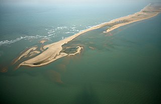
Adam's Bridge, also known as Rama's Bridge or Rama Setu, is a chain of limestone shoals, between Pamban Island, also known as Rameswaram Island, off the south-eastern coast of Tamil Nadu, India, and Mannar Island, off the north-western coast of Sri Lanka. Geological evidence suggests that this bridge is a former land connection between India and Sri Lanka.

The Palk Strait is a strait between the Tamil Nadu state of India and the Mannar district of the Northern Province of the island nation of Sri Lanka. It connects the Bay of Bengal in the northeast with Palk Bay in the southwest. The strait is 53 to 82 kilometres wide. Several rivers flow into it, including the Vaigai River of Tamil Nadu. The strait is named after Robert Palk, who was a governor of Madras (1755–1763) during the Company Raj period.

Greater Caucasus is the major mountain range of the Caucasus Mountains.

The Gulf of Mannar Marine National Park is a protected area of India consisting of 21 small islands (islets) and adjacent coral reefs in the Gulf of Mannar in the Indian Ocean. It lies 1 to 10 km away from the east coast of Tamil Nadu, India for 160 km between Thoothukudi (Tuticorin) and Dhanushkodi. It is the core area of the Gulf of Mannar Biosphere Reserve which includes a 10 km buffer zone around the park, including the populated coastal area. The park has a high diversity of plants and animals in its marine, intertidal and near shore habitats. Public access inside the Park is limited to glass bottom boat rides.

Mannar Island formerly spelt Manar Island, is part of Mannar District, Sri Lanka. It is linked to the main island of Sri Lanka by a causeway. It has an area of about 50 square kilometres, mainly covered with vegetation and sand. Adam's Bridge, is a chain of limestone shoals, between Pamban Island, also known as Rameswaram Island, off the southeastern coast of Tamil Nadu, India, and Mannar Island, off the northwestern coast of Sri Lanka. Geological evidence suggests that this bridge is a former land connection between India and Sri Lanka.

Chinchani is a census town in Palghar district in the state of Maharashtra, India.

Sultanpur is a town and a nagar panchayat in Udham Singh Nagar district in the Indian state of Uttarakhand.
Asian Highway 43 (AH43) is a route of the Asian Highway Network, running 3,024 kilometres (1,879 mi) from Asian Highway 1 in Agra, India to Matara in Sri Lanka.

A seagull intersection or continuous green T-intersection is a type of three-way road intersection, usually used on high traffic volume roads and dual carriageways. This form of intersection is popular in Australia and New Zealand, and sometimes used in the United States and other countries.
European route E 62 is a road in Europe, part of the United Nations International E-road network. Approximately 1,307 kilometers (812 mi) long, it connects the French Atlantic port city of Nantes to Genoa, largest of Italy's port cities. Between France and Italy it also passes through Switzerland, via Geneva and Lausanne. After crossing into Italy, the E 62 passes Milan, Italy's largest commercial and industrial centre, before descending to Genoa on the Mediterranean coast.
The Mannar line is a railway line in Sri Lanka. Branching off the northern line at Medawachchiya Junction, the line heads north-west through North Central and Northern provinces before terminating at the town of Talaimannar. The line is 106 kilometres (66 mi) long and has 11 stations. The line opened in 1914.

The Palk Strait bridge was a proposed 23-kilometre (14 mi) bridge over the Palk Strait, between Dhanushkodi in mainland India, and Talaimannar in Sri Lanka. The proposal, from Indian Transport Minister Nitin Gadkari, was submitted to the Asian Development Bank in June 2015. In December 2015, the Lankan Minister of Highways, Lakshman Kiriella, dismissed the proposal.


