A causeway is a track, road or railway on top of an embankment across "a low, or wet place, or piece of water". It can be constructed of earth, masonry, wood, or concrete. One of the earliest known wooden causeways is the Sweet Track in the Somerset Levels, England, that dates from the Neolithic age. Timber causeways may also be described as both boardwalks and bridges.

The island of Ireland, comprising Northern Ireland and the Republic of Ireland, has an extensive network of tens of thousands of kilometres of public roads, usually surfaced. These roads have been developed and modernised over centuries, from trackways suitable only for walkers and horses, to surfaced roads including modern motorways. The major routes were established before Irish independence and consequently take little cognisance of the border other than a change of identification number and street furniture. Northern Ireland has had motorways since 1962, and has a well-developed network of primary, secondary and local routes. The Republic started work on its motorway network in the early 1980s; and historically, the road network there was once somewhat less well developed. However, the Celtic Tiger economic boom and an influx of European Union structural funding, saw national roads and regional roads in the Republic come up to international standard quite quickly. In the mid-1990s, for example, the Republic went from having only a few short sections of motorway to a network of motorways, dual carriageways and other improvements on most major routes as part of a National Development Plan. Road construction in Northern Ireland now tends to proceed at a slower pace than in the Republic, although a number of important bypasses and upgrades to dual carriageway have recently been completed or are about to begin.

London West is a federal electoral district in London, Ontario, Canada, that has been represented in the House of Commons of Canada since 1968.

Eluru is a city and the district headquarters of West Godavari district in the Indian state of Andhra Pradesh. It is one of the 14 municipal corporations in the state and the mandal headquarters of Eluru mandal in the Eluru revenue division. The city is on the Tammileru river. The city is well known for its wool-pile carpets and hand woven products.. As of 2011 Census of India, the city had a population of 217,876. Its history dates back to the second century CE.

The N81 road is a national secondary road in Ireland, from the M50 motorway to Tullow, County Carlow, north to south. The N81 continues past Tullow for another 8 km to terminate at the village of Closh, County Carlow, where it intersects the N80. The N81 is 76.784 km (47.711 mi) long. The road is a dual carriageway between M50 motorway and west of Tallaght, known as the Tallaght Bypass or Blessington Road. It intersects with the M50 motorway at Junction 11. There are plans to extend the dual carriageway by 5 km (3.1 mi) to the urban boundary.

The N82 road is a national secondary road in Ireland, and is located entirely in Dublin. The route was designated along the Citywest Road, which runs through the Citywest Business Campus between the N81 west of Tallaght and the Citywest Interchange of the N7.

The Pir Panjal Range is a group of mountains in the Inner Himalayan region, running from east-southeast (ESE) to west-northwest (WNW) across the Indian states of Himachal Pradesh and Jammu and Kashmir where the average elevation varies from 1,400 m (4,600 ft) to 4,100 m (13,500 ft). The Himalayas show a gradual elevation towards the Dhauldhar and Pir Panjal ranges. Pir Panjal is the largest range of the lower Himalayas. Near the bank of the Sutlej river, it dissociates itself from the Himalayas and forms a divide between the rivers Beas and Ravi on one side and the Chenab on the other. The renowned Galyat mountains are also located in this range.

Golubovci is a small town in the Podgorica Municipality of Montenegro. It is the seat of the Golubovci City Municipality, a subdivision of the Podgorica Municipality. The town is located some 15 km south of the city of Podgorica, in the fertile Zeta valley. It has 3,110 residents according to 2011 census, while the Golubovci City Municipality accounts for some 16,093 residents.
Flagler Estates is an unincorporated community in Flagler and St. Johns counties in the U.S. state of Florida. It is located 8 mi (13 km) southeast of Hastings. The Flagler County portion of Flagler Estates is part of the Deltona–Daytona Beach–Ormond Beach, FL metropolitan statistical area, while the St. Johns County portion is part of the Jacksonville Metropolitan Statistical Area. As of May 2006, there were an estimated 1,500 families residing in Flagler Estates.
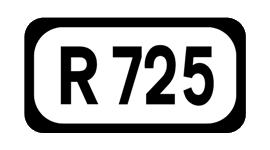
The R725 road is a regional road in Ireland. From its junction with the N80 on the western outskirts of Carlow Town it takes an easterly route to its junction with the N81 in Tullow, where it crosses the River Slaney on a bridge shared with the N80 in the town centre. It continues east to Shillelagh in County Wicklow, turns due south for 6 km, then eastwards through Carnew. It then enters County Wexford for the final 15 km stretch, terminating in Gorey at the R772.

Bhimadole is a village in Bhimadole mandal of West Godavari district of the Indian state of Andhra Pradesh. It is located in Bhimadole mandal.

A seagull intersection or continuous green T-intersection is a type of three-way road intersection, usually used on high traffic volume roads and dual carriageways. This form of intersection is popular in Australia and New Zealand, and sometimes used in the United States and other countries.
Nowy Głuchówek is a village in the administrative district of Gmina Rawa Mazowiecka, within Rawa County, Łódź Voivodeship, in central Poland.
Greek National Road 81 is a single carriageway road in Attica, Greece. It connects the northern suburbs of Athens with Kalamos, near the north coast of Attica.

The A 6 road is an A-Grade trunk road in Sri Lanka. It connects Ambepussa with Trincomallee.
The A 12 road is an A-Grade trunk road in Sri Lanka. It connects the Puttalam with Trincomallee.

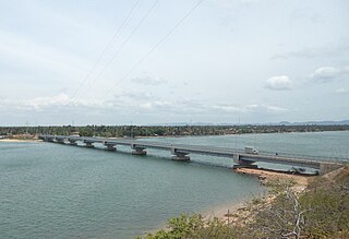
Oddamavadi Bridge is a road bridge in Oddamavadi, Sri Lanka a length of 250 meters. It crosses the Valaichchenai Lagoon at Batticaloa. The bridge is part of the A15 Batticaloa-Trincomallee highway. It comprises 2 bridges, a British Ceylon era truss bridge which is used as road-rail bridge, and a newly built bridge carrying 2 lanes of highway. The new two lane bridge is 250 m (820 ft) long and 10.5 m (34 ft) wide. The new Oddamavadi bridge was built with financial assistance of the Spanish Government and the World Bank.
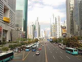
Shennan Road is a major east-west thoroughfare of Shenzhen, China.