Square kilometre or square kilometer, symbol km2, is a multiple of the square metre, the SI unit of area or surface area.

Route 53 is a state highway in Morris County in the U.S. state of New Jersey. It runs 4.66 mi (7.50 km) from U.S. Route 202 in Morris Plains north to Bloomfield Avenue in Denville Township. The route, which is a two-lane undivided highway most of its length, intersects with Route 10, Interstate 80, and U.S. Route 46. For most of its length, the route runs a short distance to the east of New Jersey Transit's Morristown Line. It passes through industrial areas and wooded residential neighborhoods along its route.

The M62 is a 107-mile-long (172 km) west–east trans-Pennine motorway in Northern England, connecting Liverpool and Hull via Manchester and Leeds; 7 miles (11 km) of the route is shared with the M60 orbital motorway around Manchester. The road is part of the unsigned Euroroutes E20 and E22.
A28 or A-28 may refer to:

A diamond interchange is a common type of road junction, used where a freeway crosses a minor road.

A single-point urban interchange, also called a single-point interchange (SPI) or single-point diamond interchange (SPDI), is a type of highway interchange. The design was created in order to help move large volumes of traffic through limited amounts of space safely and efficiently.
Stoneybatter, historically known as Bohernaglogh, is a neighbourhood of Dublin, Ireland, on the Northside of the city between the River Liffey, the North Circular Road, Smithfield Market, and Grangegorman. It is in the Dublin 7 postal district.

The European route E 22 is one of the longest European routes. It has a length of about 5,320 km (3,310 mi). Many of the E-roads have been extended into Asia since the year 2000; the E 22 was extended on 24 June 2002.

The autostrada A6 in Poland is a 25.7 km (16.0 mi) long motorway that starts at the Polish/German border at Kołbaskowo/Pomellen connecting to the German A11 autobahn. It forms a southern bypass of the Szczecin metropolitan area and terminates to the east of the city, where it becomes the S3 express road to Świnoujście. Another 4.9 km (3 mi) of the S3 road will be redesignated as A6, once improvement work is carried out. The motorway is part of the European route E28.
Deer Park is an unincorporated community in Osceola County, Florida, United States. It is located off US 192, south of the intersection with County Road 419. The community is part of the Orlando–Kissimmee Metropolitan Statistical Area.
The Kluskus First Nation is the band government of the Lhoosk’uz, a Dakelh people whose main reserve located on the Chilcotin Plateau 130 km west of the city of Quesnel, British Columbia, Canada. The First Nation is a member of the Carrier-Chilcotin Tribal Council, which includes both Tsilhqot'in and Carrier (Dakelh) communities.

The R725 road is a regional road in Ireland. From its junction with the N80 on the western outskirts of Carlow Town it takes an easterly route to its junction with the N81 in Tullow, where it crosses the River Slaney on a bridge shared with the N80 in the town centre. It continues east to Shillelagh in County Wicklow, turns due south for 6 km, then eastwards through Carnew. It then enters County Wexford for the final 15 km stretch, terminating in Gorey at the R772.

A seagull intersection or continuous green T-intersection is a type of three-way road intersection, usually used on high traffic volume roads and dual carriageways. This form of intersection is popular in Australia and New Zealand, and sometimes used in the United States and other countries.

Popowo is a village in the administrative district of Gmina Wałcz, within Wałcz County, West Pomeranian Voivodeship, in north-western Poland. It lies approximately 11 kilometres (7 mi) south of Wałcz and 129 km (80 mi) east of the regional capital Szczecin.
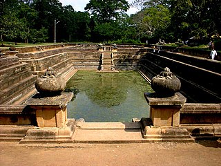
The A 10 road is an A-Grade trunk road in Sri Lanka. It connects the Katugastota with Puttalam.
Padeniya is a village in Sri Lanka. It is located within Central Province.
A Tjasker is a type of small drainage windmill used in the Netherlands. There are thirteen tjaskers remaining in Friesland.
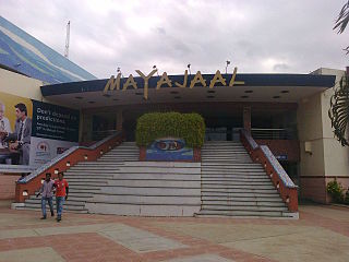
Mayajaal (Phantasmagoria) is an entertainment center in Kanathur, Chennai, India. It is located on the East Coast Road and spread over an area of 30 acres. It consists of a shopping mall, a multiplex, a sports complex and a resort. Mayajaal has a 16 screen multiplex & it is the second largest multiplex in Asia. The sports complex was started in 2003, which also hosted the Indian Cricket League matches. The Resort was opened in 2005 with 40 rooms. The 30,000 sq.ft shopping mall was opened in 2006.

The R338 road is a regional road in Ireland, located in southern County Galway.