
Garrett County (gərɛt) is the westernmost county of the U.S. state of Maryland. As of the 2010 census, the population was 30,097, making it the third-least populous county in Maryland. Its county seat is Oakland. The county was named for John Work Garrett (1820–1884), president of the Baltimore and Ohio Railroad. Created from Allegany County, Maryland in 1872, it was the last Maryland county to be formed.

Ripley is a town on Lake Erie in the westernmost part of Chautauqua County, New York, United States. The population was 2,415 at the 2010 census. The town was named after Eleazer Wheelock Ripley, a general in the War of 1812. There are no incorporated villages in the town, but there is one census-designated place: the hamlet of Ripley. The town is perhaps best known as being the western end of the New York State Thruway.
A33, A 33 or A-33 may refer to :

Vaughan was a federal electoral district in Ontario, Canada, that has been represented in the House of Commons of Canada from 2004 until 2015.

Greater Caucasus is the major mountain range of the Caucasus Mountains.

The European route E 22 is one of the longest European routes. It has a length of about 5,320 km (3,310 mi). Many of the E-roads have been extended into Asia since the year 2000; the E 22 was extended on 24 June 2002.
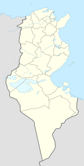
Ben Gardane or Bengardane is a commune and coastal town in south eastern Tunisia, close to the border with Libya. It is located at around 33°8′20″N11°13′0″E.

Pallipattu is a town in Tiruvallur district in the state of Tamil Nadu, India. It is located 113 kilometres from Chennai, 40 kilometres from Chittoor, 51 kilometres from Tirupathi, 36 kilometres from Tiruttani, 50 kilometres from Arakkonam and border place of the state of Andhra Pradesh

Qazigund, is a town and a notified area committee in Anantnag district in the Indian state of Jammu and Kashmir. Qazigund is located at 33.59°N 75.16°E. It has an average elevation of 1670 m (5478 feet) above mean sea level.

A national primary road is a road classification in Ireland. National primary roads form the major routes between the major urban centres. There are 2649 km of national primary roads. This category of road has the prefix "N" followed by one or two digits. Motorways are prefixed "M" followed by one or two digits.

Ramkot Fort is an ancient fort situated in Azad Kashmir, Pakistan currently beside the Mangla Dam. It is accessible through boat, 13 kilometers away from Dina and 79 kilometers by road from Mirpur, Azad Kashmir to Dadyal town. The fort is accessible from Sikah village from Dadyal side and Mangla through boats which take approximately 20 to 30 minutes. Three sides of the hilltop are surrounded by the Jhelum River, which falls into the huge reservoir of Mangla Dam. It was built by a Gakkhar named Toglu as recorded by traveler and geologist Frederick Drew in his book.

A seagull intersection or continuous green T-intersection is a type of three-way road intersection, usually used on high traffic volume roads and dual carriageways. This form of intersection is popular in Australia and New Zealand, and sometimes used in the United States and other countries.
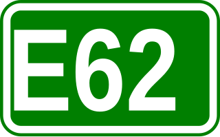
European route E 62 is a road in Europe, part of the United Nations International E-road network. Approximately 1,307 kilometers (812 mi) long, it connects the French Atlantic port city of Nantes to Genoa, largest of Italy's port cities. Between France and Italy it also passes through Switzerland, via Geneva and Lausanne. After crossing into Italy, the E 62 passes Milan, Italy's largest commercial and industrial centre, before descending to Genoa on the Mediterranean coast.
The A 1 road is an A-Grade trunk road in Sri Lanka. It connects the capital city of Colombo with Kandy.
Vridhachalam is a legislative assembly constituency in Cuddalore district in the Indian state of Tamil Nadu. Before 2009, it was part of the Chidambaram. After 2009, it is part of Cuddalore. This constituent was won by popular actor Vijaykanth, during the 2006 Assembly election, under his new party Desiya Murpokku Dravida Kazhagam.
The A 14 road is an A-Grade trunk road in Sri Lanka. It connects the Medawachchiya with Talaimannar.

National road 2 is part of the Polish national road network. The highway connects the western and eastern regions of Poland, running from Świecko at the German border to Terespol at the border with Belarus, traversing through the Lubusz, Greater Poland, Łódź Masovian and Lublin voivodeships. National road 2 is part of European highway E30.

Yakkala is a township located on Colombo-Kandy Highway (A1), 30 km away from Colombo, Sri Lanka. It forms part of Gampaha Municipal Council and belongs to Gampaha District, Western Province. Its elevation is 30m above MSL. Distances from Yakkala to main cities are; 30 km to Colombo(A1), 86 km to Kandy(A1), 4.5 km to Gampaha(A33) and 13 km to Radawana(B479).
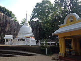
Koskandawala Sri Sunandarama Piriven Raja Maha Vihara is an old Buddhist temple in Koskandawala, Sri Lanka. The temple is located on Yakkala – Radawana road approximately 2.66 km away from Yakkala town. The temple has been formally recognized by the Government as an archaeological site in Sri Lanka.


