Ermita is a district in Manila, Philippines. Located at the central part of the city, the district is a significant center of finance, education, culture, and commerce. Ermita serves as the civic center of the city, bearing the seat of city government and a large portion of the area's employment, business, and entertainment activities.

Rizal Park, also known as Luneta Park or simply Luneta, is a historic urban park located in Ermita, Manila. It is considered one of the largest urban parks in the Philippines, covering an area of 58 hectares. The site on where the park is situated was originally known as Bagumbayan during the Spanish colonial period. It is adjacent to the historic Walled City of Intramuros.

The Department of Agriculture is the executive department of the Philippine government responsible for the promotion of agricultural and fisheries development and growth. It has its headquarters at Elliptical Road corner Visayas Avenue, Diliman, Quezon City.
This is a list of current and former national capital cities in the Philippines, which includes during the time of the Spanish colonization, the First Philippine Republic, the Commonwealth of the Philippines, the Second Republic of the Philippines, the Third Republic of the Philippines, the Fourth Republic of the Philippines and the current Fifth Republic of the Philippines.

Burnham Park, officially known as the Burnham Park Reservation, is a historic urban park located in downtown Baguio, Philippines. It was designed by eponymous American architect and Baguio city planner, Daniel Burnham.

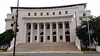
The National Museum of the Philippines is an umbrella government organization that oversees a number of national museums in the Philippines including ethnographic, anthropological, archaeological and visual arts collections. Since 1998, the National Museum has been the regulatory and enforcement agency of the government of the Philippines in the restoring and safeguarding of important cultural properties, sites, and reservations throughout the Philippines.

The Rizal Monument is a memorial in Rizal Park in Manila, Philippines built to commemorate the executed Filipino nationalist, José Rizal. The monument consists of a standing bronze sculpture of Rizal, with an obelisk, set on a stone base within which his remains are interred, holding his 2 famous novels "El Filibusterismo and Noli Me Tangere". A plaque on the pedestal's front reads: "To the memory of José Rizal, patriot and martyr, executed on Bagumbayan Field December Thirtieth 1896. This monument is dedicated by the people of the Philippine Islands."

Roxas Boulevard is a popular waterfront promenade in Metro Manila in the Philippines. The boulevard, which runs along the shores of Manila Bay, is well known for its sunsets and stretch of coconut trees. The divided roadway has become a trademark of Philippine tourism, famed for its yacht club, hotels, restaurants, commercial buildings and parks.

Rizal Avenue, also known as Avenida or Avenida Rizal, is one of Manila's main thoroughfares running from its Santa Cruz and Quiapo districts to the Bonifacio Monument (Monumento) Circle in Caloocan. Named after the national hero José Rizal, it is a part of Radial Road 9 (R-9). The LRT Line 1 elevated railroad is built above the street in its entire length, and several jeepneys ply the area taking passengers from Caloocan, Quezon City, and Valenzuela. Most of the street is within Santa Cruz, Manila. By the 1960s, economic activities shifted from Binondo to Makati. The avenue forms part of National Route 150 (N150) of the Philippine highway network.
Taft Avenue is a major road in the south of Metro Manila. It passes through three cities in the metropolis: Manila, Pasay and Parañaque. The road was named after the former Governor-General of the Philippines and U.S. President, William Howard Taft; the Philippines was a former commonwealth territory of the United States in the first half of the 20th century. The avenue is a component of National Route 170 (N170), a secondary road in the Philippine highway network, and anchors R-2 of the Manila arterial road network.

The Centennial Tower, also known as Luneta Tower, was a proposed mixed-use observation tower initially proposed to be located in Rizal Park, Manila, Philippines. It was later proposed to be built in Pasig amidst backlash over the original planned site. It was planned to be a memorial to the 100th anniversary of Philippine Independence.

Plaza Rajah Sulayman, also known as Rajah Sulayman Park, is a public square in Malate, Manila. It is bounded by Roxas Boulevard to the west, San Andres Street to the south, and Remedios Street to the north. The plaza is considered the center of Malate as it fronts the Malate Church, the main church of the district.

Plaza San Lorenzo Ruiz or Plaza Lorenzo Ruiz is a major public square in Binondo, Manila, bounded by Quintin Paredes Street to the east and Juan Luna Street to the west, parallel to the Estero de Binondo. It is the plaza that fronts the Minor Basilica of San Lorenzo Ruiz, one of the main churches of the City of Manila, and is considered the center of Binondo as a whole.

Kalaw Avenue is a short stretch of road in the Ermita district of Manila, Philippines. It forms the southern boundary of Rizal Park running east–west from San Marcelino Street to Roxas Boulevard near the center of the city. It begins as a four-lane road at the intersection with San Marcelino widening to an eight-lane divided roadway along the stretch of Rizal Park from Taft Avenue west to Roxas Boulevard. It has a short extension into the reclaimed area of Luneta and Quirino Grandstand as South Drive. The avenue's main section between Taft Avenue and Roxas Boulevard is assigned as National Route 155 (N155) of the Philippine highway network.

The Torre de Manila(lit. 'Tower of Manila'; Filipino: Tore ng Maynila) is a high-rise residential building being built by DMCI Homes in Ermita,

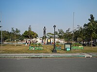
The Statue of the Sentinel of Freedom or the Lapu Lapu Monument is a monument to Lapulapu located at Rizal Park specifically at the center of the Agrifina Circle.

The National Museum of Natural History is the national natural history museum of the Philippines. It is located along Agrifina Circle in Rizal Park, Manila.
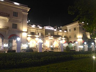
The Rizal Park Hotel is a 107-room, historic five-star hotel located along Manila Bay in Manila, Philippines. The hotel, which opened on 26 July 2017, occupies the Manila Army and Navy Club building following its redevelopment in 2014 by hotel developer Oceanville Hotel and Spa Corporation. Prior to the building's redevelopment, the building once served as the City Architect's Office and then as the Museo ng Maynila before being abandoned for several years.

The National Parks Development Committee (NPDC) is an agency of the Department of Tourism of the Philippines that is mandated to develop, preserve, and manage Rizal and Paco Parks in Manila and other parks that may be assigned to it. Its main office is located in the Old Planetarium Building, P. Burgos Drive, Rizal Park, Luneta, Manila. Both the Executive Director and the Deputy Executive Director are appointed by the President of the Philippines.

The Manila COVID-19 Field Hospital is a field hospital in Rizal Park in Manila, Philippines set up as a response against the COVID-19 pandemic, the first of its kind in the country.