
Rockland County is the southernmost county on the west side of the Hudson River in the U.S. state of New York, part of the New York City Metropolitan Statistical Area. The county's population, as of the 2010 census, was 311,687, increasing by 5.5% to a 2017 Census estimate of 328,868, making it the third-most densely populated county outside New York City within New York State. The county seat is New City. Rockland County is a suburb of New York City that borders the boroughs about 9 miles northwest of the city at their closest points, and is accessible via the New York State Thruway, after 10 exits. The name derives from "rocky land", as the area has been aptly described.
Hilton or Hylton may refer to:
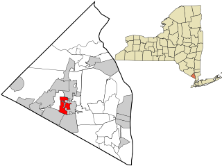
Monsey is a hamlet and census-designated place in the town of Ramapo, Rockland County, New York, United States, located north of Airmont; east of Viola; south of New Hempstead; and west of Spring Valley. The village of Kaser is completely surrounded by the hamlet of Monsey. The 2010 census listed the population at 18,412.

Suffern is a village that was incorporated in 1796 in the town of Ramapo, Rockland County, New York, United States. As of the 2010 census, Suffern's population was 10,723.

U.S. Route 219 is a spur of U.S. Route 19. It runs for 535 miles (861 km) from West Seneca, New York at an interchange with Interstate 90, to Rich Creek, Virginia, intersecting at U.S. Route 460. U.S. 219 is found in New York, Pennsylvania, Maryland, West Virginia, and Virginia. Much of the Route in West Virginia follows the old Indian warpath known as the Seneca Trail.
Interstate 287 (I-287) is an auxiliary Interstate Highway in the US states of New Jersey and New York. It is a partial beltway around New York City, serving the northern half of New Jersey and the counties of Rockland and Westchester in New York. I-287, which is signed north–south in New Jersey and east–west in New York, follows a roughly horseshoe-shaped route from the New Jersey Turnpike (I-95) in Edison Township, New Jersey, clockwise to the New England Thruway (I-95) in Rye, New York, for 98.72 miles (158.87 km). Through New Jersey, I-287 runs west from its southern terminus in Edison through suburban areas. In Bridgewater Township, the freeway takes a more northeasterly course, paralleled by U.S. Route 202 (US 202). The northernmost part of I-287 in New Jersey passes through mountainous surroundings. After crossing into New York at Suffern, I-287 turns east on the New York State Thruway (I-87) and runs though Rockland County. After crossing the Hudson River on the Tappan Zee Bridge, I-287 splits from I-87 near Tarrytown and continues east through Westchester County on the Cross-Westchester Expressway until it reaches the New England Thruway.

The Saddle River flows south through much of Bergen County, New Jersey. The river runs through densely populated suburban areas for much of its course. The river takes its name from the river near Saddell in Argyll and Bute in Scotland.

Virginia's 8th congressional district is a United States congressional district in the Commonwealth of Virginia. It comprises all of Arlington County, portions of Fairfax County and all of the independent cities of Alexandria and Falls Church.
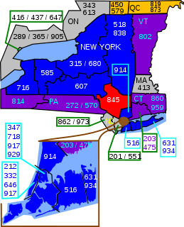
Area code 845 is a telephone area code straddling the Hudson Valley region of the U.S. state of New York. 845 serves Rockland, Putnam, Orange, and Ulster counties, and parts of Dutchess and Sullivan, Delaware, Greene, and Columbia counties. Area code 845 was created on June 5, 2000, from most of area code 914, which was retained by Westchester County.

Bloomfield is an unincorporated community in Loudoun County, Virginia. It is situated at the intersection of Airmont and Bloomfield Roads.

New York State Route 59 (NY 59) is an east–west state highway in southern Rockland County, New York, in the United States. The route extends for 14.08 miles (22.66 km) from NY 17 in Hillburn to U.S. Route 9W (US 9W) in Nyack. In Suffern, it has a concurrency with US 202 for 0.05 miles (0.08 km). NY 59 runs parallel to the New York State Thruway its entire route. The routing of NY 59 became a state highway in 1911 and was signed as NY 59 in the late 1920s.
The following is a list of lists of the cities, towns and villages of the United States separated by state, territory or district name.

Suffern Central School District, formerly the Ramapo Central School District, is a school district headquartered in Hillburn, a village in the Town of Ramapo in Rockland County, New York, United States located north of Suffern; east of Orange County, New York; south of Viola and west of Montebello.
Tallman is a hamlet in the town of Ramapo, Rockland County, New York, United States, located north of the state of New Jersey; east of Suffern; south of Montebello and west of Airmont. It is located north-northwest of New York City.

Lucien Whiting Powell (1846–1930) was a renowned landscape painter who gave the village of Airmont, Virginia its name for its scenic westward views. Powell, himself, could be considered a native of Airmont, having been born a few miles southeast, near Upperville, Virginia.
