The Brazilian Institute of Geography and Statistics is the agency responsible for official collection of statistical, geographic, cartographic, geodetic and environmental information in Brazil. IBGE performs a decennial national census; questionnaires account for information such as age, household income, literacy, education, occupation and hygiene levels.

Salinas is a municipality in the northeast of the Brazilian state of Minas Gerais.

Prados is a Brazilian municipality located in the state of Minas Gerais. The city belongs to the mesoregion of Campo das Vertentes and to the microregion of Sao Joao del Rei. In 2020, the estimated population was 9,080.

Durandé is a Brazilian municipality located in the state of Minas Gerais. The city belongs to the mesoregion of Zona da Mata and to the microregion of Manhuaçu. Districts within the county are St. John Figueira and São José da Figueira.

Manga is a municipality in the north of the state of Minas Gerais in Brazil. It is located on the left bank of the São Francisco River. It is connected to Januária by paved BR-135, anis 112 km away. Neighboring municipalities are Matias Cardoso, Montalvânia, Miravânia, Juvenília, and São João das Missões. The distance to the state capital is 720 km. As of 2020 the population was 18,226 in an area of 1,950 km².
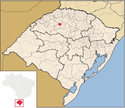
Santa Vitória is a municipality in the west of the Brazilian state of Minas Gerais. As of 2020, the population was estimated at 19,872. It became a municipality in 1948.

Frei Gaspar is a Brazilian municipality located in the northeast of the state of Minas Gerais. Its population as of 2020 was estimated to be 5,869 people living in a total area of 628 km². The city belongs to the mesoregion of Vale do Mucuri and to the microregion of Teófilo Otoni. It became a municipality in 1962.

Carmo do Cajuru is a municipality in the state of Minas Gerais in the Southeast region of Brazil.

Itaúna is a municipality in the state of Minas Gerais in the Southeast region of Brazil.
Minduri is a municipality in the state of Minas Gerais in the Southeast region of Brazil.

Dom Viçoso is a municipality in the state of Minas Gerais in the Southeast region of Brazil.

Bueno Brandão is a municipality in the state of Minas Gerais in the Southeast region of Brazil.

São João da Mata is a municipality in the state of Minas Gerais in the Southeast region of Brazil.
São João Evangelista is a municipality in the state of Minas Gerais in the Southeast region of Brazil.

Peçanha is a municipality in the state of Minas Gerais in the Southeast region of Brazil.

Heliodora is a municipality in the state of Minas Gerais in the Southeast region of Brazil. As of 2020, the estimated population was 6,591.
The Immediate Geographic Region of Poços de Caldas is one of the 10 immediate geographic regions in the Intermediate Geographic Region of Pouso Alegre, one of the 70 immediate geographic regions in the Brazilian state of Minas Gerais and one of the 509 of Brazil, created by the National Institute of Geography and Statistics (IBGE) in 2017.

The Immediate Geographic Region of Montes Claros is one of the 7 immediate geographic regions in the Intermediate Geographic Region of Montes Claros, one of the 70 immediate geographic regions in the Brazilian state of Minas Gerais and one of the 509 of Brazil, created by the National Institute of Geography and Statistics (IBGE) in 2017.
The Immediate Geographic Region of Diamantina is one of the 7 immediate geographic regions in the Intermediate Geographic Region of Teófilo Otoni, one of the 70 immediate geographic regions in the Brazilian state of Minas Gerais and one of the 509 of Brazil, created by the National Institute of Geography and Statistics (IBGE) in 2017.