| Akköprü Dam | |
|---|---|
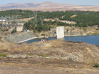
The dam's reservoir | |
| Official name | Akköprü Baraji |
| Country | Turkey |
| Status | Operational |
| Construction began | 1995 |
| Opening date | 2009 |
| Owner(s) | DSI |
| Dam and spillways | |
| Type of dam | Embankment |
| Impounds | Dalaman River |
| Height | 112 m (367 ft) |
| Dam volume | 13,250,000 m3 (17,330,346 cu yd) |
| Reservoir | |
| Total capacity | 384,000,000 m3 (311,314 acre⋅ft) |
| Surface area | 9 km2 (3 sq mi) |
| Power Station | |
| Turbines | 2 x 57.5 MW Francis-type |
| Installed capacity | 115 MW |
| Annual generation | 343 GWh |

Akköprü Dam is an embankment dam on the Dalaman River in Muğla Province, Turkey, built between 1995 and 2009. It supports a 115 MW power station and provides water for the irrigation of 14,192 hectares (35,070 acres).
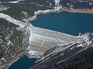
An embankment dam is a large artificial dam. It is typically created by the placement and compaction of a complex semi-plastic mound of various compositions of soil, sand, clay, or rock. It has a semi-pervious waterproof natural covering for its surface and a dense, impervious core. This makes such a dam impervious to surface or seepage erosion. Such a dam is composed of fragmented independent material particles. The friction and interaction of particles binds the particles together into a stable mass rather than by the use of a cementing substance.

Muğla Province is a province of Turkey, at the country's south-western corner, on the Aegean Sea. Its seat is Muğla, about 20 km (12 mi) inland, while some of Turkey's largest holiday resorts, such as Bodrum, Ölüdeniz, Marmaris and Fethiye, are on the coast in Muğla.

Turkey, officially the Republic of Turkey, is a transcontinental country located mainly in Western Asia, with a smaller portion on the Balkan Peninsula in Southeast Europe. East Thrace, located in Europe, is separated from Anatolia by the Sea of Marmara, the Bosphorous strait and the Dardanelles. Turkey is bordered by Greece and Bulgaria to its northwest; Georgia to its northeast; Armenia, the Azerbaijani exclave of Nakhchivan and Iran to the east; and Iraq and Syria to the south. Ankara is its capital but Istanbul is the country's largest city. Approximately 70 to 80 per cent of the country's citizens identify as Turkish. Kurds are the largest minority; the size of the Kurdish population is a subject of dispute with estimates placing the figure at anywhere from 12 to 25 per cent of the population.