Coordinates: 49°39′26″N57°20′22″E / 49.65722°N 57.33944°E

A geographic coordinate system is a coordinate system that enables every location on Earth to be specified by a set of numbers, letters or symbols. The coordinates are often chosen such that one of the numbers represents a vertical position and two or three of the numbers represent a horizontal position; alternatively, a geographic position may be expressed in a combined three-dimensional Cartesian vector. A common choice of coordinates is latitude, longitude and elevation. To specify a location on a plane requires a map projection.
| Akkemer Ақкемер اقكەمەر | |
|---|---|
 Akkemer | |
| Coordinates: 49°39′26″N57°20′22″E / 49.65722°N 57.33944°E | |
| Country | |
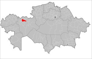
| Region | Aktobe |
| Elevation | 268 m (879 ft) |
| Time zone | West Kazakhstan Time (UTC+5) |
| • Summer (DST) | West Kazakhstan Time (UTC+5) |
Akkemer (also known as Aqkemer [1] (Kazakh : Ақкемер, Aqkemer, اقكەمەر)) is a town in Aktobe Region, west Kazakhstan. It lies at an altitude of 268 m (879 ft). [1]

Kazakh or Kazak belongs to the Kipchak branch of the Turkic languages. It is closely related to Nogai, Kyrgyz, and Karakalpak. Kazakh is the official language of the Republic of Kazakhstan and a significant minority language in the Ili Kazakh Autonomous Prefecture in Xinjiang, China and in the Bayan-Ölgii Province of Mongolia. Kazakh is also spoken by many ethnic Kazakhs through the former Soviet Union, Afghanistan, Iran, Turkey, and Germany.
Aktobe Region is a region of Kazakhstan. The Aktobe regional capital is the city of Aktobe, with a population of more than 340,000. The region itself has a population 678,900. The name "Aktobe" comes from Kazakh "Ақ" (white) and "төбе" (hill); supposedly, Aktobe's initial settlers were able to see white mountains far to the north.

Kazakhstan, officially the Republic of Kazakhstan, is the world's largest landlocked country, and the ninth largest in the world, with an area of 2,724,900 square kilometres (1,052,100 sq mi). It is a transcontinental country largely located in Asia; the most western parts are located in Europe. Kazakhstan is the dominant nation of Central Asia economically, generating 60% of the region's GDP, primarily through its oil/gas industry. It also has vast mineral resources.