Al-Zaazu'

Last updated
Al-Zaazu'
الزعزوع
Village
Syria adm location map.svg
Red pog.svg
Al-Zaazu'
Location in Syria
Coordinates: 36°38′40″N39°13′32″E / 36.64444°N 39.22556°E / 36.64444; 39.22556 Coordinates: 36°38′40″N39°13′32″E / 36.64444°N 39.22556°E / 36.64444; 39.22556
CountryFlag of Syria.svg  Syria
Governorate Raqqa Governorate
District Tell Abyad District
Nahiyah Suluk
Population (2004 census) [1]
  Total 779
Time zone UTC+3 (EET)
  Summer (DST) UTC+2 (EEST)

Al-Zaazu' (Arabic : الزعزوع) is a village in northern Syria, administratively part of Raqqa Governorate, located north of Raqqa. According to the Syria Central Bureau of Statistics (CBS), al-Zaazu' had a population of 779 in the 2004 census. [1]

Syria Country in Western Asia

Syria, officially the Syrian Arab Republic, is a country in Western Asia, bordering Lebanon to the southwest, the Mediterranean Sea to the west, Turkey to the north, Iraq to the east, Jordan to the south, and Israel to the southwest. A country of fertile plains, high mountains, and deserts, Syria is home to diverse ethnic and religious groups, including Syrian Arabs, Greeks, Armenians, Assyrians, Kurds, Circassians, Mandeans and Turks. Religious groups include Sunnis, Christians, Alawites, Druze, Isma'ilis, Mandeans, Shiites, Salafis, Yazidis, and Jews. Sunni make up the largest religious group in Syria.

Raqqa Governorate Governorate in Syria

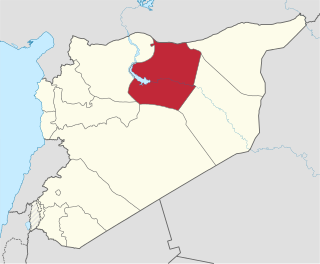
Raqqa Governorate is one of the fourteen governorates (provinces) of Syria. It is situated in the north of the country and covers an area of 19,616 km². The governorate has a population of 921,000. The capital is Raqqa. The Islamic State of Iraq and Levant claimed full control of this province as of August 24, 2014 when its fighters captured Tabqa Airbase in the southwest part of the province. However, the Syrian Democratic Forces now control much of the province; all of the area north of the Euphrates River including the provincial capital of Raqqa and the city of al-Thawrah are under SDF control, with the government holding the southern part of the governorate after a successful offensive was launched with the aid of Liwa al-Quds, tribal militias and Russian air support, which resulted in the recapture of the city of Resafa, and the capture of many oil fields in Ar-Raqqah province, including various oil and gas stations.

The Central Bureau of Statistics (CBS) is the statistical agency responsible for the gathering of "information relating to economic, social and general activities and conditions" in the Syrian Arab Republic. The office is answerable to the office of the Prime Minister and has its main offices in Damascus. The CBS was established in 2005 and is administered by an administrative council headed by the deputy prime minister for economic affairs.

Related Research Articles

Raqqa District District in Raqqa, Syria

Raqqa District is a district of the Raqqa Governorate in northern Syria. Administrative centre is the city of Raqqa. At the 2004 census, the district had a population of 503,960.

Al-Thawrah District District in Raqqa, Syria

Al-Thawrah District is a district of the Raqqa Governorate in northern Syria. Administrative centre is the city of al-Thawrah. At the 2004 census, the district had a population of 159,840.

Al-Qutayfah District District in Rif Dimashq, Syria

al-Qutayfah District is a district of the Rif Dimashq Governorate in southern Syria. Administrative centre is the city of al-Qutayfah. At the 2004 census, the district had a population of 119,283.

Al-Tall District District in Rif Dimashq, Syria

al-Tall District is a district of the Rif Dimashq Governorate in southern Syria. Administrative centre is the city of al-Tall. At the 2004 census, the district had a population of 115,937.

Tell Jabin Village in Aleppo, Syria

Tell Jabin is a Kurdish town in northern Syria, administratively part of the A'zaz District of Aleppo Governorate, located north of Aleppo. Nearby localities include Tell Rifaat and Kafr Naya to the north, Mare' to the northeast, Bayanoun, Mayer and al-Zahraa to the west. According to the Syria Central Bureau of Statistics, Tell Jabin had a population of 2,579 in the 2004 census.

Urum al-Sughra Village in Aleppo, Syria

Urum al-Sughra is a village in western Aleppo Governorate, northwestern Syria. With a population of 637 as per the 2004 census, the village administratively belongs to Nahiya Urum al-Kubrah in Atarib District.

Al-Qahtaniyah, Raqqa Governorate Village in Raqqa Governorate, Syria

Al-Qahtaniya is a village in northern Syria, administratively part of Raqqa Governorate, located just northwest of Raqqa. According to the Syria Central Bureau of Statistics (CBS), al-Qahtaniya had a population of 2,490 in the 2004 census.

Ithriya Village in Hama, Syria

Ithriya is a Syrian village located in Al-Saan Nahiyah in Salamiyah District, Hama. According to the Syria Central Bureau of Statistics (CBS), Asrieh had a population of 2118 in the 2004 census.

Bir al-Helou Town in al-Hasakah, Syria

Bir al-Helou is a town in central al-Hasakah Governorate, northeastern Syria. It is administrative center of the Nahiya Bir al-Helou al-Wardiya consisting of 72 municipalities.

Al-Arishah Town in al-Hasakah, Syria

al-Arishah is a town in southern al-Hasakah Governorate, northeastern Syria. It is administrative center of the Nahiya al-Arishah District, which consists of 20 municipalities.

Ayn Issa Town and nahiyah in Raqqa, Syria

Ayn Issa is a town and nahiyah within the Tell Abyad District of Raqqa Governorate in Syria. It is located halfway between the border town Tell Abyad and the regional capital Raqqa.

Ayn al-Arab Subdistrict Subdistrict in Aleppo, Syria

Ayn al-Arab Subdistrict is a subdistrict of Ayn al-Arab District in northeastern Aleppo Governorate, northern Syria. Administrative centre is the city of Kobani. At the 2004 census, the subdistrict had a population of 81,424.

Zunqul Village in Aleppo, Syria

Zunqul, also spelled Zūnqal, Zounqul or Zornaqal, is a village located 14 kilometers (8.7 mi) northwest of Manbij in northern Syria. In the 2004 census, it had a population of 1,966.

Shuyukh Tahtani Subdistrict Subdistrict in Aleppo, Syria

Shuyukh Tahtani Subdistrict is a subdistrict of Ayn al-Arab District in Aleppo Governorate of northern Syria. Administrative centre is Shuyukh Tahtani.

Al-Bab Subdistrict Subdistrict in Aleppo, Syria

Al-Bab Subdistrict, also called Nahiya Markaz al-Bab, is a subdistrict of al-Bab District in northern Aleppo Governorate, northwestern Syria. Administrative centre is al-Bab. At the 2004 census, the subdistrict had a population of 112,219.

Tadef Subdistrict Subdistrict in Aleppo, Syria

Tadef Subdistrict is a subdistrict of al-Bab District in northern Aleppo Governorate, northwestern Syria. Administrative centre is Tadef. At the 2004 census, the subdistrict had a population of 41,951.

Arima Subdistrict Subdistrict in Aleppo, Syria

Arima Subdistrict is a subdistrict of al-Bab District in northern Aleppo Governorate, northwestern Syria. Administrative centre is Arima. At the 2004 census, the subdistrict had a population of 32,041.

Al-Karamah, Raqqa Governorate Town in Raqqa, Syria

Al-Karamah is a Syrian town located in Raqqa District, 26 km east of Raqqa city. According to the Syria Central Bureau of Statistics (CBS), Al-Karamah had a population of 7,034 in the 2004 census.

Al-Sabkhah Town in Raqqa, Syria

Al-Sabkhah is a Syrian town located in Raqqa District, Raqqa. According to the Syria Central Bureau of Statistics (CBS), Al-Sabkhah had a population of 11,567 in the 2004 census.

Al-Mansurah, Raqqa Governorate Town in Raqqa, Syria

Al-Mansura is a Syrian town located in Al-Thawrah District, Raqqa. According to the Syria Central Bureau of Statistics (CBS), Al-Mansura had a population of 16,158 in the 2004 census.

References

  1. 1 2 "2004 Census Data for Suluk nahiyah" (in Arabic). Syrian Central Bureau of Statistics . Retrieved 15 October 2015. Also available in English: "2004 Census Data". UN OCHA . Retrieved 15 October 2015.