This page is based on this
Wikipedia article Text is available under the
CC BY-SA 4.0 license; additional terms may apply.
Images, videos and audio are available under their respective licenses.
Alresford railway station may refer to:
Bighton is a village and civil parish in the City of Winchester district of Hampshire, England. According to the 2011 census it had a population of 341, compared with 319 in 2001. The village is about 3 miles (4.8 km) north-east of New Alresford.

Cheriton Is a village]] and civil parish near Alresford in Hampshire, England. The settlement is perhaps most famous for being close to the site of the English Civil War Battle of Cheriton 1644. Cheriton is the Source of the River Itchen. The village has two distinct sections: Cheriton and New Cheriton which is beside the A272 half a mile from the main village

Alresford railway station in Hampshire, England, is the terminus of the Watercress Line from Alton. It is in the small town of New Alresford, 7½ miles (12 km) northeast of Winchester, close to the town's market square, tea rooms, many small shops and museum.

Medstead and Four Marks railway station is a railway station in the English county of Hampshire, serving the villages of Medstead and Four Marks. At 644 ft above sea level, it is currently (2016) the highest operational standard-gauge railway station in Southern England.

Alresford railway station is on the Sunshine Coast Line, a branch of the Great Eastern Main Line, in the East of England, serving the village of Alresford, Essex. It is 57 miles 63 chains (93.0 km) down the line from London Liverpool Street and is situated between Wivenhoe to the west and Great Bentley to the east. In official literature it is shown as Alresford (Essex) in order to distinguish it from the station of the same name in Hampshire. Its three-letter station code is ALR.
Alresford Cricket Club was one of the strongest cricket teams in England during the late 18th century. It represented the adjacent small towns of New Alresford and Old Alresford in Hampshire. According to John Arlott, between about 1770 and 1795 Alresford "stood higher in cricket than any town its size has done in the history of the game".

Brown Candover is a village in Hampshire, England. The village belongs to the parish of the Candovers and its nearest town is New Alresford, 5 miles (8.0 km) away from the village.

Medstead is a village and civil parish in the East Hampshire district of Hampshire, England. Its nearest town is Alton, which lies 4.3 miles (6.9 km) northeast of the village. According to the 2011 census, the village had a population of 2,036 people. The parish covers an area of 1,536 acres (622 ha) and has an average elevation of approximately 600 feet (180 m) above sea level. One of the county's high points at 716 feet (218 m), King's Hill, runs through Medstead and Bentworth.
Swarraton is a small village in the City of Winchester district of Hampshire, England. At the 2011 Census the village population was included in the civil parish of Northington. It lies three miles (5 km) from New Alresford covers an acreage of 755 acres (3.06 km2). Its nearest railway station is in New Alresford, on the Mid-Hants section of the London and South Western Railway.

Chilton Candover is a village in Hampshire, England. It has an acreage of 1,451 acres (5.87 km2) and sits in the valley of the River Alre. The village is situated on the main road from Basingstoke to Winchester, and consists of a few scattered houses built of brick and roofed with slate, thatch and tiles. To the north lies an underground churchyard enclosed by a flint stone wall, now abandoned and overgrown with weeds.
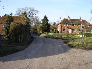
Fobdown is a hamlet in Hampshire, England. It lies 2 miles north-west from its nearest town, New Alresford. It is in the civil parish of Old Alresford.
Gundleton is a village in Hampshire, England. It is in the civil parish of Bighton. Its nearest railway station is the restored Watercress Line in New Alresford, about 3 miles (4.8 km) from the village.
Sir John Leigh was an English landowner, soldier and politician who sat in the House of Commons between 1597 and 1611.

Itchen Stoke and Ovington is an English civil parish consisting of two adjoining villages in Hampshire, England, 2 miles (3.2 km) west of Alresford town centre in the valley of the River Itchen, 5 miles (8.0 km) north-east of Winchester, and 2 miles (3.2 km) south-east of Itchen Abbas.
Hampshire 1 is an English level 10 Rugby Union league for teams based in Hampshire and the Isle of Wight. Up until the 2017-18 season it was known as Hampshire 2 but was changed to Hampshire 1 following restructuring of the Hampshire leagues, which would see the re-introduction of a third division as well as 2nd and 3rd XV sides joining for the first time. Each year some of the clubs in this division also take part in the RFU Junior Vase - a level 9-12 national competition.
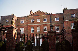
Old Alresford House is an 18th century Georgian country house in Old Alresford, Hampshire, England. It is a Grade II* listed building.


