Amiens Street, Dublin

Last updated
Amiens Street Amiens Street, Dublin.jpg
Amiens Street
LUAS tram crossing Amiens Street into Store Street. A LUAS tram crosses Amiens Street from the direction of Store Street - geograph.org.uk - 1732747.jpg
LUAS tram crossing Amiens Street into Store Street.

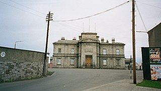
Amiens Street, located in Dublin, Ireland was named after Viscount Amiens, Earl of Aldborough. It is one of the most frequented streets by railway passengers using Dublin Connolly station which was formerly called Amiens Street Station opened in 1844. It was renamed after James Connolly. The Italianate architecture of the Dublin and Drogheda Railway station buildings are the focal point of the street. The street was one of the boundaries of Dublin's red-light district, Monto, [1] that existed between the 1860s - 1920s.

Dublin capital and largest city in Ireland

Dublin is the capital of, and largest city in, Ireland. It is on the east coast of Ireland, in the province of Leinster, at the mouth of the River Liffey, and is bordered on the south by the Wicklow mountains. It has an urban area population of 1,173,179, while the population of the Dublin Region, as of 2016, was 1,347,359, and the population of the Greater Dublin area was 1,904,806.

Republic of Ireland Ireland, a country in north-western Europe, occupying 5/6 of the island of Ireland; succeeded the Irish Free State (1937)

Ireland, also known as the Republic of Ireland, is a country in north-western Europe occupying 26 of 32 counties of the island of Ireland. The capital and largest city is Dublin, which is located on the eastern part of the island, and whose metropolitan area is home to around a third of the country's over 4.8 million inhabitants. The sovereign state shares its only land border with Northern Ireland, a part of the United Kingdom. It is otherwise surrounded by the Atlantic Ocean, with the Celtic Sea to the south, Saint George's Channel to the south-east, and the Irish Sea to the east. It is a unitary, parliamentary republic. The legislature, the Oireachtas, consists of a lower house, Dáil Éireann, an upper house, Seanad Éireann, and an elected President who serves as the largely ceremonial head of state, but with some important powers and duties. The head of government is the Taoiseach, who is elected by the Dáil and appointed by the President; the Taoiseach in turn appoints other government ministers.

Earl of Aldborough, of the Palatinate of Upper Ormond, was a title in the Peerage of Ireland held by the Noble House of Stratford. It was created on 9 February 1777, along with the courtesy title of Viscount Amiens, for John Stratford, 1st Viscount Aldborough, a descendant of the English Stratford family. He had already been created Baron Baltinglass, of Baltinglass, in the County of Wicklow, on 21 May 1763, and Viscount Aldborough, of the Palatinate of Upper Ormond, on 22 July 1776. These titles were also in the Peerage of Ireland. Three of his sons, the second, third and fourth Earls, all succeeded in the titles. They became extinct on the death of the latter's grandson, the sixth Earl, in 1875.

Contents

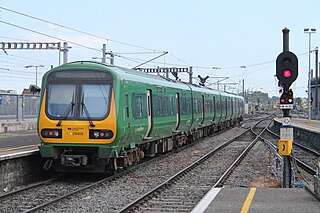
The street links the International Financial Services Centre and the Custom House Quay across the tramlines of the LUAS where there is street level tram terminal and interchange for the trains in Dublin Connolly. Across the road over the pedestrian crossing is Talbot Street. Further up the street with an over bridge carrying the DART (en route to Tara Street across the Liffey) over the street to the North Strand Road heading towards Fairview.

International Financial Services Centre Financial centre in Dublin, Ireland

The International Financial Services Centre began in 1987 as a special economic zone on a derelict 11 hectare site near the centre of Dublin, with EU approval to apply a 10% corporate tax rate for designated financial services activities on the site. Before the expiry of this EU approval in 2005, the Irish Government legislated in 1998/99 to effectively "turn the entire country into an IFSC" by reducing the overall Irish corporate tax rate from 32% to 12.5%. The legal requirement for a specific IFSC geographic area was thus removed, and the term International Financial Services ("IFS") sector is now sometimes used.

The Custom House

The Custom House is a neoclassical 18th century building in Dublin, Ireland which houses the Department of Housing, Planning and Local Government. It is located on the north bank of the River Liffey, on Custom House Quay between Butt Bridge and Talbot Memorial Bridge.

Pedestrian crossing Point on a road at which some means are employed to assist pedestrians wishing to cross

A pedestrian crossing or crosswalk is a place designated for pedestrians to cross a road, street, blvd and ave. Pelican crosswalks are designed to keep pedestrians together where they can be seen by motorists, and where they can cross most safely across the flow of vehicular traffic.

The 19th century Irish novelist, Charles Lever, was born in No. 35 Amiens Street.

Charles Lever Irish writer

Charles James Lever was an Irish novelist and raconteur, whose novels, according to Anthony Trollope, were just like his conversation.

See also

Related Research Articles

Dublin Area Rapid Transit an electrified rapid transit railway network serving Dublin, Republic of Ireland

The Dublin Area Rapid Transit system is an electrified rapid transit railway network serving the coastline and city centre of Dublin, capital city of the Ireland. The service makes up the core of Dublin's suburban railway network, stretching from Greystones, County Wicklow at its southernmost terminus to Howth and Malahide in north County Dublin. The DART serves 31 stations and consists of 53 kilometres of track, and carries in the region of 16 million passengers per year.

Rosslare Europort

Rosslare Europort is a modern seaport located at Rosslare Harbour in County Wexford, Ireland, near the southeastern-most point of Ireland, handling passenger and freight ferries to and from Wales and France.

Luas Light rail system in Dublin, Ireland

Luas is a tram/light rail system in Dublin, Ireland. There are two main lines: The Green Line, which began operating on 30 June 2004, and the Red Line which opened on 26 September 2004. Since then, both lines have been extended and split into different branches further out of the city. The two lines, as of 2017, now intersect and connect within Dublin City Centre. The system now has sixty-seven stations and 42.5 kilometres (26.4 mi) of revenue track., which in 2018 carried 41.8 million passengers, an increase of 11.2% compared to 2017.

Dublin Port

Dublin Port is the seaport of Dublin, Ireland, of both historical and contemporary economic importance. Approximatively two-thirds of Ireland's port traffic travels via the port, which is by far the busiest on the island of Ireland. Recently, the port and its land, mostly at the eastern end of Dublin's Northside, but also with a southern section, were valued at €25 billion – €30 billion.

Connolly station

Connolly station or Dublin Connolly is the busiest railway station in Dublin and Ireland, and is a focal point in the Irish route network. On the North side of the River Liffey, it provides InterCity, Enterprise and commuter services to the north, north-west, south-east and south-west. The North-South Dublin Area Rapid Transit (DART) and Luas light rail services also pass through the station. The station offices are the headquarters of Irish Rail, Iarnród Éireann. Opened in 1844 as Dublin Station, the ornate facade has a distinctive Italianate tower at its centre.

Monto was the nickname for the one-time red light district in Dublin, the capital of Ireland. Monto was roughly the area bounded by Talbot Street, Amiens Street, Gardiner Street and Seán McDermott Street. The name is derived from Montgomery Street, which runs parallel to the lower end of Talbot Street towards what is now Connolly Station. It was immortalised as "Nighttown" in the "Circe" chapter of James Joyce's famous work, Ulysses, where the central protagonists Leopold Bloom and Stephen Dedalus together visit a brothel.

Cabra, Dublin Inner western Northside suburb of Dublin, Ireland

Cabra is an inner suburb on the northside of Dublin city in Ireland. It is approximately 2 kilometres (1.2 mi) northwest of the city centre, in the administrative area of Dublin City Council. It was commonly known as Cabragh until the early 20th century. Largely located between the Royal Canal and the Phoenix Park, it is primarily a residential suburb, with a range of institutions and some light industry. Cabra is governed by Dublin City Council, and served by bus, light rail and mainline rail; it lies across one of the main roads from central Dublin to the orbital motorway, the Navan Road.

Broadstone, Dublin One of three divisions of Phibsboro, inner suburb of Dublin, Ireland

Broadstone is one of the three neighbourhoods that make up present-day Phibsboro in Dublin, Ireland. The most southerly of these, it begins just two kilometres north of the Liffey Bridge at Ormond Quay. The area is triangular, bounded by Phibsborough Road and Constitution Hill to the West, North Circular Road to the north, and Dorset Street and Bolton Street to the south-east. The postal district for the area is Dublin 7.

Transport 21

Transport 21 was an Irish infrastructure plan, announced in November 2005. Its aims were to greatly expand Ireland's transport network. A cost estimate of €34 billion was attached to the plan at the time.

Lisburn railway station

Lisburn railway station serves the city of Lisburn in County Antrim, Northern Ireland.

Belfast–Dublin line

The Belfast–Dublin Main Line is a main and busiest railway route on the island of Ireland that connects Dublin Connolly station in the Republic of Ireland and Belfast Lanyon Place station in Northern Ireland.

Drumcondra railway station railway station

Drumcondra is a railway station on the Dublin Connolly to Longford commuter service. A limited number of Sligo and Longford to Dublin services stop at Drumcondra.

Dublin Suburban Rail

The Dublin Suburban Rail network,, is a railway network that serves the city of Dublin, Ireland, most of the Greater Dublin Area and outlying towns. The system is made up of five lines:

Bray Daly railway station

Bray Daly railway station is a station situated in Bray in County Wicklow, Ireland. It is located adjacent to Bray seafront and is 600 m from Bray Main Street via Florence Road or Quinsborough Road.

Talbot Street

Talbot Street is a city-centre street located on Dublin's Northside and is one of the principal shopping streets of Dublin, running from Connolly station and the International Financial Services Centre at Amiens Street in the east to Marlborough Street in the west. The street is named after Charles Chetwynd-Talbot, 2nd Earl Talbot, Lord Lieutenant of Ireland, 1817-21. One of the street's most famous residents was Alfie Byrne, ten times Lord Mayor of Dublin.

North Strand Road is a street in the Northside of Dublin, Ireland. It links the city centre from Connolly Station to Fairview by road.

Dublin–Sligo railway line

The Dublin to Sligo main line is a railway route operated by Iarnród Éireann in Ireland. It starts in Dublin Connolly station, terminating at Sligo Mac Diarmada railway station in Sligo. The route is double track as far as Maynooth, being single track with passing loops between there and Sligo.

Dublin Broadstone railway station

Broadstone railway station was the Dublin terminus of the Midland Great Western Railway (MGWR), located in the Dublin suburb of Broadstone. The site also contained the MGWR railway works and a steam locomotive motive power depot. A LUAS tram station opened at the front of the station in 2017.

Westmoreland Street Street in Dublin, Ireland

Westmoreland Street is a street in the southern city-centre of Dublin, Ireland. It is currently a one-way street and part a north-bound section of the R138 road.

Store Street

Store Street is a short and busy street in Dublin running from Amiens Street, Dublin at right angles. The street has tramlines with the LUAS running into Busáras and running at right angles towards Abbey Street, Dublin. Across the road is The Custom House. There is also a police station called Store Street Garda Síochána.

References

  1. "Red-light alert". Love & Sex. Irish Independent. 10 April 2011. Retrieved 2013-10-02.

Coordinates: 53°21′05″N06°14′59″W / 53.35139°N 6.24972°W / 53.35139; -6.24972

Geographic coordinate system Coordinate system

A geographic coordinate system is a coordinate system that enables every location on Earth to be specified by a set of numbers, letters or symbols. The coordinates are often chosen such that one of the numbers represents a vertical position and two or three of the numbers represent a horizontal position; alternatively, a geographic position may be expressed in a combined three-dimensional Cartesian vector. A common choice of coordinates is latitude, longitude and elevation. To specify a location on a plane requires a map projection.