Andhra Pradesh Capital Region

Last updated

Andhra Pradesh Capital Region
Andhra Pradeah Capital Region.jpg
Map showing Andhra Pradesh Capital Region spread across Guntur and Krishna districts with the city of Amaravati on the banks of River Krishna
CountryFlag of India.svg  India
State Andhra Pradesh
Districts Guntur District
NTR District
Krishna District
Eluru District
Palnadu district
Bapatla district
Headquarters Vijayawada
Major Cities Guntur,Vijayawada, Amaravati,Tenali, Mangalagiri, Tadepalli, Sattenapalli, Nuzvid
Area
  Total8,603 km2 (3,322 sq mi)
Population
 (2011) [1]
  Total5,873,588
  Density680/km2 (1,800/sq mi)
Time zone UTC+5:30 (Indian Standard Time)
  Summer (DST) UTC+5:30 (Indian Standard Time)
Website APCRDA

Andhra Pradesh Capital Region is the metropolitan area of the de facto capital city Amaravati of Andhra Pradesh in India. The region is spread across the districts of NTR, Krishna, Guntur, Palnadu, Bapatla and Eluru. It includes the major ancient cities of Vijayawada, Guntur and Tenali. Vijayawada is the largest city and headquarters of the region. It is one the most populated metropolitan areas in Andhra Pradesh. [2] [ verification needed ] The region is under the jurisdiction of Andhra Pradesh Capital Region Development Authority and covers an area of 8,352.69 km2 (3,224.99 sq mi) under 58 mandals . [3] The de facto capital city Amaravati is an urban notified area and will cover 217.23 km2 (83.87 sq mi), within the Andhra Pradesh Capital Region. [4]

Contents

Background

After the bifurcation of United Andhra Pradesh, the newly formed Government of Andhra Pradesh constituted the Andhra Pradesh Capital Region Development Authority in 2014 and the Andhra Pradesh Capital Region was formed with a extent of 7,319 km2 (2,826 sq mi). The limits of the region was expanded on 22 September 2015, which resulted in addition and removal of the mandals and villages taking the total area to 8,603 km2 (3,322 sq mi). [5] [6] [7] As of 1 August 2020, government of Andhra Pradesh proposed three capitals, which are Visakhapatnam as the executive capital, Amaravati as the legislative capital, and Kurnool as the judicial capital, but the process was cancelled and reverted back to the original 2014 plan of a singular capital city at Amaravati on 22 November 2021. [8]

Administration and Jurisdiction

The Andhra Pradesh Capital Region Development Authority is responsible for the administration and governance of the entire region under the Department of Municipal Administration and Urban Development of Andhra Pradesh.

The region is partially spread across 6 districts and subdivided into 8 zones for administrative purposes. It consists of 33 complete and 25 part mandals, totaling 58 mandals with 3 municipal corporations, 10 municipalities and 1006 gram panchayats spanning across 953 revenue villages. [9] [10] [5] [11]

ZoneDistrictMandal
Amaravati Guntur district Thullur mandal
Western Zone NTR district Kanchikacherla mandal
Veerullapadu mandal
Nandigama mandal (Part)
Chandarlapadu mandal (Part)
Penuganchiprolu mandal (Part)
South West Zone Palnadu district Amaravati mandal
Pedakurapadu mandal
Krosuru mandal (Part)
Sattenapalle mandal (Part)
Atchampet mandal (Part)
Muppalla mandal (part)
Southern Zone Guntur district Pedanandipadu mandal (Part)
Tadikonda mandal
Guntur mandal
Medikonduru mandal
Pedakakani mandal
Vatticherukuru mandal
Pratipadu mandal (Part)
Phirangipuram mandal (Part)
Palnadu district Edlapadu mandal (Part)
Nadendla mandal (Part)
South East Zone Guntur district Duggirala mandal
Tenali mandal
Chebrolu mandal
Bhattiprolu mandal
Kollipara mandal
Tsunduru mandal
Ponnur mandal (Part)
Bapatla district Vemuru mandal
Kollur mandal
Amruthaluru mandal
Central Zone Guntur district Tadepalle mandal
Mangalagiri mandal
NTR district Vijayawada Rural mandal
Vijayawada Urban mandal
Ibrahimpatnam mandal
Penamaluru mandal
Northern Zone G. Konduru mandal
Mylavaram mandal (Part)
Eluru district Agiripalli mandal
Nuzividu mandal (Part)
North East Zone Krishna district Gannavaram mandal
Unguturu mandal
Bapulapadu mandal (Part)
Eastern Zone Vuyyuru mandal
Kankipadu mandal
Pamidimukkala mandal
Thotlavalluru mandal
Pedaparupudi mandal
Gudlavalleru mandal (Part)
Nandivada mandal (Part)
Mopidevi mandal (Part)
Ghantasala mandal (Part)
Challapalli mandal (Part)
Pamarru mandal (Part)
Gudivada mandal (Part)
Movva mandal (Part)

See also

Related Research Articles

<span class="mw-page-title-main">Tenali</span> City in Andhra Pradesh, India

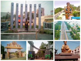
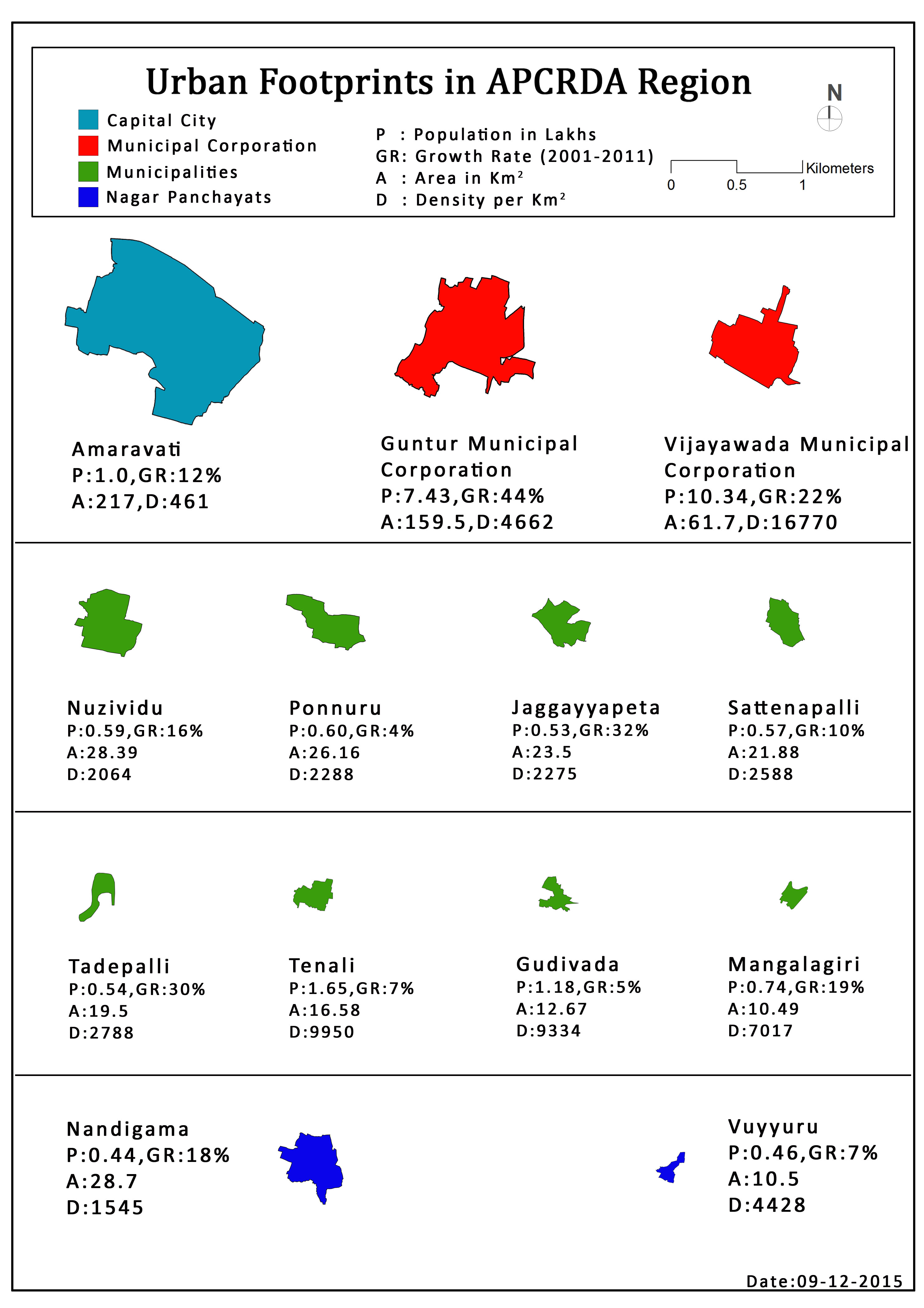
Tenali is a city in Guntur district of the Indian state of Andhra Pradesh. It is a municipality, and the headquarters of Tenali mandal and Tenali revenue division. The city is renowned for art, culture, drama, and hence, it is called Andhra Paris. It is one of the twelve urban local bodies in Andhra Pradesh Capital Region and the twelfth most populous town in the state, with a population of 199,345 as of 2011. Tenali town is also part of Andhra Pradesh Capital Region Development Authority (APCRDA).

Gudivada is a city in Krishna district of the Indian state of Andhra Pradesh. It is a municipality and the headquarters of Gudivada mandal in Gudivada revenue division. It is one of the cities in the state to be a part of Andhra Pradesh Capital Region. It is the twenty-seventh most populous city in Andhra Pradesh and the three-hundredth most populous city in India with a population of 118,167 according to the 2011 Census of India.

<span class="mw-page-title-main">Thullur</span> Village in Andhra Pradesh, India

Thulluru is a Village in Guntur district of Indian state of Andhra Pradesh. It is located at a distance of 4 km from Krishna River and was a village in Thulluru mandal of Guntur district, prior to its denotification as gram panchayat.

Piduguralla is a City in Palnadu district of the Indian state of Andhra Pradesh.The City is the headquarters of Piduguralla mandal and administered under Gurazala revenue division. The City is also known as Lime City of India as there are abundant reserves of limestone..

<span class="mw-page-title-main">Duggirala</span> Village in Andhra Pradesh, India

Duggirala is a village in Guntur district of the Indian state of Andhra Pradesh. It is the mandal headquarters of Duggirala mandal in Tenali revenue division. It is one of the major turmeric trading centres in the country.

<span class="mw-page-title-main">Kollipara</span> Village in Andhra Pradesh, India

Kollipara is a village in Guntur district of the Indian state of Andhra Pradesh. It is the headquarters of Kollipara mandal in Tenali revenue division. And it was one of the capital for Pericchedi.

Pedakakani is a village in the Guntur district of the Indian state of Andhra Pradesh. It is located in Pedakakani mandal of Guntur revenue division. Hindu shrine of Shiva, Sri Bhramaramba Malleswara Swamy Temple is located in the village.

Rayapudi is a neighbourhood and a part of Urban Notified Area of Amaravati, the state capital of the Indian state of Andhra Pradesh. It was a village in Thullur mandal of in Guntur district, prior to its denotification as gram panchayat.

Sattenapalle is a town in Palnadu district of the Indian state of Andhra Pradesh. It is a municipality and the headquarters of Sattenapalle mandal under Sattenapalle revenue division. It is also part of APCRDA region.

<span class="mw-page-title-main">Tadepalle mandal, Guntur district</span> Mandal in Andhra Pradesh, India

Tadepalle mandal is one of the 18 mandals in Guntur district of the Indian state of Andhra Pradesh. It is under the administration of Tenali revenue division and the headquarters are located at Tadepalle town. The mandal is situated on the banks of Krishna River, bounded by Thullur and Mangalagiri mandals. from the mandal are under the jurisdiction of Andhra Pradesh Capital City.

<span class="mw-page-title-main">Thullur mandal</span> Mandal in Andhra Pradesh, India

Thullur mandal is one of the 18 mandals in Guntur district of the Indian state of Andhra Pradesh. It is under the administration of Guntur Revenue Division and the headquarters are located at Thullur. The mandal is situated on the banks of Krishna River, bounded by Amaravathi, Tadikonda, Tadepalle and Mangalagiri mandals. The mandal is also a part of the new capital city of Andhra Pradesh to be developed. 18 villages from the mandal fall under the jurisdiction of Andhra Pradesh Capital City.

<span class="mw-page-title-main">Andhra Pradesh Capital Region Development Authority</span>

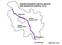
The Andhra Pradesh Capital Region Development Authority, Amaravati, ACT No. 27 of 2020. It was notified on 31 July 2020 by the Government of Andhra Pradesh as per The Andhra Pradesh Capital Region Development Authority Repeal Act, 2020, it replaced the Andhra Pradesh Capital Region Development Authority Act, 2014. The authority has a jurisdictional area of 8,352.69 km2, covering the districts of Guntur, Eluru, NTR, Krishna, Palnadu, and Bapatla.

<span class="mw-page-title-main">Amaravati</span> Capital of Andhra Pradesh, India

Amaravati is the greenfield capital of the Indian state of Andhra Pradesh. It is situated at the heart of the state, on the right bank of the river Krishna in Guntur district. It is near to Dharanikota, the ancient city site nearby, that served as the capital of Satavahana dynasty more than 2,200 years ago.

<span class="mw-page-title-main">Undavalli</span> Neighbourhood in Guntur, Andhra Pradesh, India

Undavalli is a southern neighbourhood of Vijayawada city of the Indian state of Andhra Pradesh. It was a village in Tadepalle mandal of Guntur district, prior to its de-notification as gram panchayat. 5th century Buddhist and Hindu Undavalli Caves which signify Monolithic Indian rock-cut architecture are present at this place. It is a part of Vijayawada Urban Agglomeration.

<span class="mw-page-title-main">Krishnayapalem</span> Neighbourhood in Guntur, Andhra Pradesh, India

Krishnayapalem is a village of the Indian state of Andhra Pradesh. It is a denotification as gram panchayat in Mangalagiri mandal of Guntur district.

<span class="mw-page-title-main">Penumaka</span> Village in Andhra Pradesh, India

Penumaka is a part of Mangalagiri Tadepalle Municipal Corporation part of Guntur district which is part of Andhra Pradesh. It was a village in Tadepalle mandal of Guntur district, prior to its de–notification as gram panchayat.

<span class="mw-page-title-main">Vykuntapuram</span> Village in Andhra Pradesh, India

Vykuntapuram, also spelled as Vaikuntapuram, is a village in Guntur district of the Indian state of Andhra Pradesh. It is located in Amaravathi mandal of Guntur revenue division. The village forms a part of Andhra Pradesh Capital Region, under the jurisdiction of APCRDA.

Bhattiprolu mandal is one of the 25 mandals in Bapatla district of the Indian state of Andhra Pradesh. It is under the administration of Tenali revenue division and the headquarters are located at Bhattiprolu. The mandal is situated on the banks of Krishna River, bounded by Kollur, Vemuru, Cherukupalle, Nagaram and Repalle mandals. The mandal headquarters ten villages are included in Andhra Pradesh Capital Region.

Athota is a village in Guntur district of the Indian state of Andhra Pradesh. It is located in Kollipara mandal of Tenali revenue division.

<span class="mw-page-title-main">Tenali Municipality</span> Local self-government in Tenali, Andhra Pradesh, India

Tenali Municipality is the local self-government in Tenali, a city in the Indian state of Andhra Pradesh. It is classified as a special grademunicipality.

References

  1. "Demography". APCRDA. Government of Andhra Pradesh. Archived from the original (PDF) on 13 September 2016. Retrieved 30 June 2016.
  2. reddy, u sudhakar (19 August 2016). "Vijayawada is third densely packed city; 31,200 people in every square km". Deccan Chronicle.
  3. "A.P. Capital Region" (PDF). APCRDA. Government of Andhra Pradesh. p. 15. Archived from the original (PDF) on 13 September 2016. Retrieved 1 September 2016.
  4. Mahalakshmi, BV (22 October 2015). "Foundation stone of Andhra Pradesh's new capital Amaravati laid by PM Narendra Modi". The Financial Express. Archived from the original on 1 July 2016. Retrieved 5 June 2016.
  5. 1 2 "District wise mandals and villages covered in Krishna and Guntur districts" (PDF). Andhra Pradesh Capital Region Development Authority. Government of Andhra Pradesh. Archived from the original (PDF) on 23 September 2015. Retrieved 23 September 2015.
  6. "Declaration of A.P. Capital Region" (PDF). APCRDA. Municipal Administration and Urban Development Department. 22 September 2015. Archived from the original (PDF) on 21 February 2016. Retrieved 21 February 2016.
  7. Subba Rao, GVR (23 September 2015). "Capital region expands as CRDA redraws boundaries". The Hindu. Vijayawada. Retrieved 31 October 2015.
  8. "High court extends status quo on three capitals".
  9. "Urban Footprints in APCRDA Region". APCRDA. Retrieved 27 June 2016.
  10. "AP Capital Region Development Authority comes into being". The Hindu. Hyderabad. 31 December 2014. Retrieved 6 January 2015.
  11. "Andhra Pradesh Capital Region Development Authority" (PDF). APCRDA. Government of Andhra Pradesh. Retrieved 12 April 2023.

16°30′30″N80°38′30″E / 16.50833°N 80.64167°E / 16.50833; 80.64167