The geography of Egypt relates to two regions: North Africa and Southwest Asia.

The Nile is a major north-flowing river in northeastern Africa, and is the longest river in Africa and the disputed longest river in the world, as the Brazilian government says that the Amazon River is longer than the Nile. The Nile, which is about 6,650 km (4,130 mi) long, is an "international" river as its drainage basin covers eleven countries: Tanzania, Uganda, Rwanda, Burundi, the Democratic Republic of the Congo, Kenya, Ethiopia, Eritrea, South Sudan, Republic of the Sudan, and Egypt. In particular, the Nile is the primary water source of Egypt and Sudan.

The Blue Nile is a river originating at Lake Tana in Ethiopia. With the White Nile, it is one of the two major tributaries of the Nile. The Blue Nile supplies about 80% of the water in the Nile during the rainy season.

Lake Nasser is a vast reservoir in southern Egypt and northern Sudan. It is one of the largest man-made lakes in the world. Before construction, Sudan was against the building of Lake Nasser because it would encroach on land in the North, where the Nubian people lived. They would have to be resettled. In the end Sudan's land near the area of Lake Nasser was mostly flooded by the lake.

The Atbarah River in northeast Africa rises in northwest Ethiopia, approximately 50 km north of Lake Tana and 30 km west of Gondar. It flows about 805 km (500 mi) to the Nile in north-central Sudan, joining it at the city of Atbarah. The river's tributary, the Tekezé (Setit) River, is perhaps the true upper course of the Atbarah, as the Tekezé follows the longer course prior to the confluence of the two rivers in northeastern Sudan. The Atbarah is the last tributary of the Nile before it reaches the Mediterranean.

The Tekezé or Täkkäze River, also spelled Takkaze, is a major river of Ethiopia. For part of its course it forms a section the westernmost border of Ethiopia and Eritrea. The river is also known as the Setit in Eritrea, western Ethiopia, and eastern Sudan. According to materials published by the Ethiopian Central Statistical Agency, the Tekezé River is 608 kilometers (378 mi) long. The canyon which it has created is the deepest in Africa and one of the deepest in the world, at some points having a depth of over 2000 meters.

The Mareb River, is a river flowing out of central Eritrea. Its chief importance is defining part of the boundary between Eritrea and Ethiopia, between the point where the Mai Ambassa enters the river at 14°53.6′N37°54.8′E to the confluence of the Balasa with the Mareb at 14°38′N39°1.3′E.

The Merowe Dam, also known as Merowe High Dam, Merowe Multi-Purpose Hydro Project or Hamdab Dam, is a large dam near Merowe Town in northern Sudan, about 350 kilometres (220 mi) north of the capital Khartoum. Its dimensions make it the largest contemporary hydropower project in Africa. It is situated on the river Nile, close to and inundating the 4th Cataract where the river divides into multiple smaller branches with large islands in between. Merowe is a city about 40 kilometres (25 mi) downstream from the construction site at Hamdab. The main purpose for building the dam was the generation of electricity.

The Baro River is a river in southwestern Ethiopia, which defines part of Ethiopia's border with South Sudan. From its source in the Ethiopian Highlands it flows west for 306 kilometres (190 mi) to join the Pibor River. The Baro-Pibor confluence marks the beginning of the Sobat River, a tributary of the White Nile.

Malakal is a city in South Sudan and second largest city after the national capital Juba.
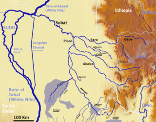
The Pibor River is a river in eastern South Sudan, which defines part of South Sudan's border with Ethiopia. From its source near Pibor Post it flows north for about 320 kilometres (200 mi), joining the Baro River to form the Sobat River, which is a tributary of the White Nile.
The Lesser Angereb is a river of northern Ethiopia. According to G.W.B. Huntingford, it rises north of Gondar, and flows southeast of that city to join the Magech River, which empties into Lake Tana. The latitude and longitude of its confluence with the Magech is 12°34′54″N37°27′55″E
The Yabus River rises in the far west of Ethiopia, in Asosa Zone, flows west into Sudan past the town of Yabus, then enters South Sudan. At the town of Bunj it turns south west and enters the Machar Marshes, where it loses its identity.

The Gilgel Gibe III Dam is a 250 m high roller-compacted concrete dam with an associated hydroelectric power plant on the Omo River in Ethiopia. It is located about 62 km (39 mi) west of Sodo in the Southern Nations, Nationalities, and Peoples' Region. Once fully commissioned, it will be the third largest hydroelectric plant in Africa with a power output of about 1870 Megawatt (MW), thus more than doubling total installed capacity in Ethiopia from its 2007 level of 814 MW. The Gibe III dam is part of the Gibe cascade, a series of dams including the existing Gibe I dam and Gibe II power station as well as the planned Gibe IV and Gibe V dams. The existing dams are owned and operated by the state-owned Ethiopian Electric Power, which is also the client for the Gibe III Dam.
Egypt's environmental problems include, but are not limited to, water scarcity, air pollution, damage to historic monuments, animal welfare issues and deficiencies in its waste management system.
Ethiopia is called the water tower of Africa due to its combination of mountainous areas with a comparatively large share of water resources in Africa. Only a fraction of this potential has been harnessed so far, 1% at the beginning of the 21st century. In order to become the powerhouse of Africa, Ethiopia is actively exploiting its water resources by building dams, reservoirs, irrigation and diversion canals and hydropower stations. The benefits of the dams are not only limited to hydropower. Many dams are multi-purpose dams that are also designed to provide water for irrigation, drinking water and flood control. However, hydropower is expected to be the main benefit of the dams.

The Grand Ethiopian Renaissance Dam, formerly known as the Millennium Dam and sometimes referred to as Hidase Dam, is a gravity dam on the Blue Nile River in Ethiopia that has been under construction since 2011. It is in the Benishangul-Gumuz Region of Ethiopia, about 15 km (9 mi) east of the border with Sudan. At 6.45 gigawatts, the dam will be the largest hydroelectric power plant in Africa when completed, as well as the seventh largest in the world. As of October 2019, the work stood at approximately 70% completion. Once completed, the reservoir could take anywhere between 5 and 15 years to fill with water, depending on hydrologic conditions during the filling period and agreements reached between Ethiopia, Sudan, and Egypt.
Sudan is a country that is half desert and much of the population suffers from a shortage of clean drinking water as well as a reliable source of water for agriculture. With the Nile river in the east of the country, parts of Sudan have substantial water resources, but those in the west have to rely on wadis, seasonal wells which often dry up. These imbalances in water availability are a source of hardship, as well as a source of conflict. While storage facilities are limited, many local communities have constructed makeshift dams and reservoirs, weirs, which help in stabilizing farming communities. Farmers also utilize hafirs to store rain water which falls in the rainy season, but groundwater remains a vital source of water for over 80% of Sudanese people. For decades, political instability has led to terrible conditions and thwarted many projects and relief efforts, but aid is making its way through. Several water infrastructure projects have been enacted in recent years, with both domestic and international sources of funding. Funding from the UN has provided 9,550 local farmers with better access to water and fertile soils. A project which also plans to replant forest cover in the wadi to reverse desertification.


