County Wicklow is a county in Ireland. The last of the traditional 32 counties to be formed, as late as 1606, it is part of the Mid-East Region and also part of the traditional province of Leinster. It is named after the town of Wicklow, which derives from the Old Norse name Víkingaló, meaning "Vikings' Meadow". Wicklow County Council is the local authority for the county. The county had a population of 142,425 at the 2016 census.

County Wexford is a county in Ireland. It is in the province of Leinster and is part of the South-East Region. Named after the town of Wexford, it was based on the historic Gaelic territory of Hy Kinsella, whose capital was Ferns. Wexford County Council is the local authority for the county. The population of the county was 149,722 at the 2016 census.

Wicklow is the county town of County Wicklow in Ireland. Located south of Dublin on the east coast of the island, it has a population of 10,584 according to the 2016 census. The town is to the east of the N11 route between Dublin and Wexford. Wicklow is also linked to the rail network, with Dublin commuter services now extending to the town. Additional services connect with Arklow, Wexford and Rosslare Europort, a main ferry port. There is also a commercial port, mainly importing timber and textiles. The River Vartry is the main river which flows through the town.

The Wicklow Mountains form the largest continuous upland area in the Republic of Ireland. They occupy the whole centre of County Wicklow and stretch outside its borders into the counties of Dublin, Wexford and Carlow. Where the mountains extend into County Dublin, they are known locally as the Dublin Mountains. The highest peak is Lugnaquilla at 925 metres.

The Battle of Vinegar Hill, was an engagement during the Irish Rebellion of 1798 on 21 June 1798 when over 13,000 British soldiers launched an attack on Vinegar Hill outside Enniscorthy, County Wexford, the largest camp and headquarters of the Wexford United Irishmen. It marked a turning point in the rebellion, as it was the last attempt by the United Irishmen to hold and defend ground against the British military. The battle was actually fought in two locations: on Vinegar Hill itself and in the streets of nearby Enniscorthy.

A regional road in Ireland is a class of road not forming a major route, but nevertheless forming a link in the national route network. There are over 11,600 kilometres of regional roads. Regional roads are numbered with three-digit route numbers, prefixed by "R".
The Battle of Ballyellis on 30 June 1798 was a clash during the Irish Rebellion of 1798, between a surviving column of the dispersed Wexford rebel army and pursuing British forces which resulted in a victory for the rebels.

2RN is the trading name of RTÉ Transmission Network Ltd, a wholly owned subsidiary of Raidió Teilifís Éireann, formerly trading as RTÉNL, which runs Ireland's principal digital terrestrial television and radio broadcast networks. In December 2002 it became an incorporated company and subsidiary of RTÉ, it was previously a division within RTÉ. It operates 12 main TV and radio transmitter sites and many smaller relays and transposers, which carry television and/or radio. It also provides site hosting for mobile telephone operators, the emergency services, wireless broadband and other private mobile communications service providers.

Kippure at 757 metres (2,484 ft), is the 56th–highest peak in Ireland on the Arderin scale, and the 72nd–highest peak on the Vandeleur-Lynam scale. Kippure is situated in the far northern sector of the Wicklow Mountains, where it lies on the border of the counties of Dublin and Wicklow in Ireland. Kippure is the County Top for Dublin, and its height and positioning over Dublin city have made its summit an important site for transmission masts, which are highly visible from a distance. Kippure's slopes feed into the Liffey Head Bog which forms the source of the River Liffey. The summit can be easily accessed from the east via a path that lies off the R115 road along the route to the Sally Gap.

Laragh is a small village in County Wicklow, Ireland. It lies at the junction of three roads through the Wicklow Mountains and is primarily known for its proximity to the monastic settlement of Glendalough. Sally Gap and the Glenmacnass Waterfall are to the north, to the west is Glendalough and the Wicklow Gap, and to the south is the Glenmalure Valley.

The R756 road is a regional road in Ireland running west–east from Dunlavin to Laragh. Its entire 32 km (20 mi) length is within County Wicklow crossing east–west through the Wicklow Gap.

Wicklow Gap is one of the highest Irish mountain passes served by an asphalted road. It is located in County Wicklow, Ireland.

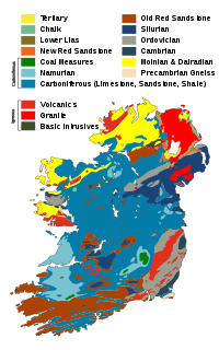
The geology of Ireland consists of the study of the rock formations on the island of Ireland. It includes rocks from every age from Proterozoic to Holocene and a large variety of different rock types is represented. The basalt columns of the Giant's Causeway together with geologically significant sections of the adjacent coast have been declared a World Heritage Site. The geological detail follows the major events in Ireland's past based on the geological timescale.

Mullaghcleevaun at 849 metres (2,785 ft), is the 15th–highest peak in Ireland on the Arderin scale, and the 20th–highest peak on the Vandeleur-Lynam scale. Mullaghcleevaun is in the central sector of the Wicklow Mountains range, in Wicklow, Ireland; it is the 2nd highest peak in Wicklow after Lugnaquilla. Mullaghcleevaun lies on the main "central spine" of the whole range that runs from Kippure in the north, to Lugnaquillia in the south; and in particular, it lies on the continuous "central boggy ridge" that runs from the Sally Gap to Tonelagee.

Camaderry at 699 metres (2,293 ft), is the 90th-highest peak in Ireland on the Arderin scale, and the 112th-highest peak on the Vandeleur-Lynam scale. Camaderry is situated in the southern sector of the Wicklow Mountains range, and forms a broad horseshoe around the valley of Glendalough with the hydroelectric station at Turlough Hill 681 metres (2,234 ft), and the mountains of Conavalla 734 metres (2,408 ft), and Lugduff 652 metres (2,139 ft). Camaderry has a subsidiary summit of Camaderry South East Top 677 metres (2,221 ft), and both lie across the deep Wicklow Gap from Tonelagee 817 metres (2,680 ft), which sits on the "central spine" of the Wicklow Mountains range.

Croghan Mountain or Croghan Kinsella at 606 metres (1,988 ft), is the 211th–highest peak in Ireland on the Arderin scale, and the 258th–highest peak on the Vandeleur-Lynam scale. Croghan is situated at the far southeastern end of the Wicklow Mountains on the Wicklow and Wexford border, in Ireland.

Slieveboy is a mountain located in north County Wexford, Ireland.

Coolafancy is a village in County Wicklow in Ireland. It is located roughly between Tinahely and Carnew, close to the neighbouring village of Coolboy. The area of Coolafancy is often referred to as Crosspatrick on maps. Coolafancy contains the only primary national school in the area, St. Mary's National School. The school serves the village itself and also the village of Coolboy and surrounding areas like Hillbrook, Coolroe, Cummer and Cummerduff.

Killiney Hill is the southernmost of the two hills which form the southern boundary of Dublin Bay. Crowned by an obelisk, the hill is 153 metres high and has views over the surrounding areas: Dublin to the northwest; the Irish Sea and the mountains of Wales to the east and southeast; and Bray Head and the Wicklow Mountains to the south. The hill was higher in the past but material was removed from the summit for the construction of the pier at Dún Laoghaire.

Kilanerin–Ballyfad GAA, often called simply Kilanerin, is a Gaelic football, hurling and ladies' Gaelic football club based in Kilanerin (Killinierin), County Wexford, Ireland.


