
Contra Costa County is a county in the state of California in the United States. As of the 2010 census, the population was 1,049,025. The county seat is Martinez. It occupies the northern portion of the East Bay region of the San Francisco Bay Area, and is primarily suburban. The county's name is Spanish for "opposite coast", referring to its position on the other side of the bay from San Francisco. Contra Costa County is included in the San Francisco–Oakland–Hayward, CA Metropolitan Statistical Area.

Antioch is the second largest city in Contra Costa County, California, United States. Located in the East Bay region of the San Francisco Bay Area along the San Joaquin-Sacramento River Delta, it is a suburb of San Francisco and Oakland. The city's population was 102,372 at the 2010 census and estimated to be 110,542 in 2015.
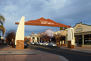
Brentwood is a city in Contra Costa County, California, United States. It is located in the East Bay region of the San Francisco Bay Area. The population is 51,481 as of 2010, an increase of 121 percent from 23,302 at the 2000 census.

Point Pinole Regional Shoreline is a regional park on the shores of the San Pablo Bay, California, in the United States. It is approximately 2,315 acres (9.37 km2) in area, and is operated by the East Bay Regional Park District. It includes the Dotson Family Marsh and the Point Pinole Lagoon and hosts the North Richmond Shoreline Festival.
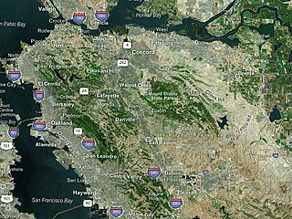
The eastern region of the San Francisco Bay Area, commonly referred to as the East Bay, includes cities along the eastern shores of the San Francisco Bay and San Pablo Bay. The region has grown to include inland communities in Alameda and Contra Costa Counties. With a population of roughly 2.5 million in 2010, it is the most populous subregion in the Bay Area.
Tri Delta Transit, formally the Eastern Contra Costa Transit Authority, is a joint powers agency of the governments of Pittsburg, Antioch, Oakley, Brentwood, and Contra Costa County that provides bus service for the eastern area of Contra Costa County, California, United States. Tri Delta Transit local buses connect to the BART rapid transit system at Pittsburg/Bay Point and Concord. Tri Delta Transit buses also connect with County Connection bus service, WestCAT bus service, Delta Breeze bus service and Amtrak at shared bus stops.
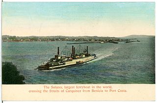
The Solano was a large railroad ferry, built as a sidewheel paddleboat that operated across the Carquinez Strait between Benicia and Port Costa in California.
Kennedy Grove Regional Recreation Area,(KGRRA), also known simply as Kennedy Grove, is located in West Contra Costa County, California at the base of San Pablo Dam. The nearest city is El Sobrante, California. Created in 1967, it contains a three-mile hiking trail with an elevation of 760 feet (230 m). The Grove features many large eucalyptus trees, picnic areas, volleyball nets, playgrounds, and horseshoe pits. Bird watching is popular here because hawks are almost always spotted. Some hikers have reported seeing golden and bald eagles around the reservoir. There is no camping allowed. Parking is $5 with an extra $2 fee for a dog. Dogs have to be on the leash around the lawn but they are allowed off the leash in remote parts of the park. The park is open from 8 a.m. to dusk.
Miller/Knox Regional Shoreline is a 295-acre (1.19 km2) bayside park in the Brickyard Cove neighborhood of the Point Richmond District in Richmond, California.
Somersville Towne Center is a regional shopping mall located in Antioch, California. Previously named County East Mall until 2004, the 501,259 square feet (46,570 m2) mall is managed by Urban Retail Properties. Originally opened in 1966, it is strategically positioned in one of the fastest growing areas of the San Francisco Bay area, east Contra Costa County. Along with high population growth, east Contra Costa County is also experiencing sizable household income increases.

John A. Nejedly was a district attorney and Republican state senator who represented Contra Costa County, California from 1958 to 1980.

The Contra Costa Canal is a 47 mi (76 km) aqueduct in the U.S. state of California. Its construction began in 1937, with delayed completion until 1948 due to World War II shortages in labor and materials. A portion of the canal's right of way has been developed as the Contra Costa Canal Regional Trail, a biking and walking trail, and is managed by the East Bay Regional Park District.

Carquinez Strait Regional Shoreline is a regional park, part of the East Bay Regional Park District system, located in northwestern Contra Costa County, California.
Contra Loma Regional Park is a 780-acre (320 ha) regional park in Contra Costa County, California. It is part of the East Bay Regional Parks system. It is located in the city of Antioch and includes an 80-acre (32 ha) reservoir.

Radke Martinez Regional Shoreline (RMRS) is a regional park on the shoreline of Carquinez Strait in Martinez, located in northern Contra Costa County, California. Formerly known as the Martinez Regional Shoreline, it was renamed on December 6, 2016, in honor of the late Ted Radke and his late wife Kathy Radke.
Kiptopeke State Park is a state park located in the southern end of the Eastern Shore of Virginia and the Delmarva Peninsula in Northampton County, near Cape Charles. From 1949, the site was owned by the Virginia Ferry Corporation and used through 1964 as the northern terminus for the Little Creek-Cape Charles Ferry service which crossed the lower Chesapeake Bay from the Eastern Shore / Delmarva to Norfolk and Hampton Roads harbor on the Western Shore. In 1964, the ferry service was replaced by the Chesapeake Bay Bridge-Tunnel which opened up giving automobile traffic convenient access to the park, the Cape, Delmarva and "The Shore" to the urban centers to the west in North Carolina, Virginia, Maryland and the District of Columbia.

Antioch is a Bay Area Rapid Transit (BART) station on the Antioch–SFO/Millbrae line served by diesel multiple unit technology. It is located in the median of Highway 4 at Hillcrest Avenue in Antioch, California.
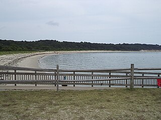
Big Break Regional Shoreline is a regional park in Oakley, Contra Costa County, northern California. It is a part of the East Bay Regional Park District system.
Little Hills Picnic Ranch, sometimes called the "Ranch at Little Hills" or just "Little Hills" is a park in Contra Costa County, California near San Ramon. It is located at 18103 Bollinger Canyon Road and is adjacent to Las Trampas Regional Wilderness. Managed by the East Bay Regional Parks District (EBRPD), it is classed as a "picnic park," accessible only by reservation. There are no facilities for camping.


