Aoraki/Mount Cook National Park is in the South Island of New Zealand, near the town of Twizel. Aoraki / Mount Cook, New Zealand's highest mountain, and Aoraki/Mount Cook Village lie within the park. The area was gazetted as a national park in October 1953 and consists of reserves that were established as early as 1887 to protect the area's significant vegetation and landscape.[1]
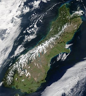
The South Island, also officially named Te Waipounamu, is the larger of the two major islands of New Zealand in surface area; the other being the smaller but more populous North Island. It is bordered to the north by Cook Strait, to the west by the Tasman Sea, and to the south and east by the Pacific Ocean. The South Island covers 150,437 square kilometres (58,084 sq mi), making it the world's 12th-largest island. It has a temperate climate.
New Zealand is a sovereign island country in the southwestern Pacific Ocean. The country has two main landmasses—the North Island, and the South Island —and around 600 smaller islands. It has a total land area of 268,000 square kilometres (103,500 sq mi). New Zealand is about 2,000 kilometres (1,200 mi) east of Australia across the Tasman Sea and 1,000 kilometres (600 mi) south of the Pacific island areas of New Caledonia, Fiji, and Tonga. Because of its remoteness, it was one of the last lands to be settled by humans. During its long period of isolation, New Zealand developed a distinct biodiversity of animal, fungal, and plant life. The country's varied topography and its sharp mountain peaks, such as the Southern Alps, owe much to the tectonic uplift of land and volcanic eruptions. New Zealand's capital city is Wellington, and its most populous city is Auckland.
Twizel is the largest town in the Mackenzie District, in the Canterbury Region of New Zealand's South Island. The town was founded in 1968 to house construction workers on the Upper Waitaki Hydroelectric Scheme. Twizel has a resident population of 1,280 ; during the summer, holidaymakers nearly triple the town's population.
Even though most of the park is alpine terrain, it is easily accessible. The only road access into Aoraki/Mount Cook National Park is via State Highway 80, which starts near Twizel, at 65 kilometres (40mi) distance the closest town to the park, and leads directly to Mount Cook Village, where the road ends.[2] The village is situated within the park, however, it consists only of a hotel and motels, as well as housing and amenities for the staff of the hotel and motels and other support personnel.[3]
State Highway 80 is a South Island state highway in New Zealand. Known as Mount Cook Road, it is a tourist road between the settlements of Twizel and Mount Cook Village. About 55 kilometres in length, it is mostly two lane, with a few single-lane bridges. Tourists travelling between Christchurch and Queenstown often deviate here and travel to New Zealand's highest mountain Aoraki/Mount Cook.
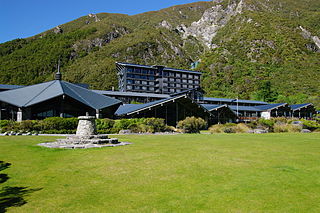
The Hermitage Hotel, Mount Cook Village is a hotel located inside the Aoraki/Mount Cook National Park, 65 kilometres (40 mi) north of Twizel.
Geography
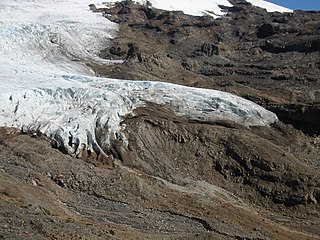
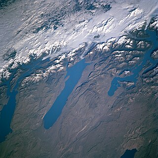
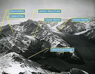
Upper Mueller Glacier, from Mueller HutThe Main Divide with Mt Sefton and The Footstool, from Hooker Valley. On the right side in the background is Aoraki / Mount Cook
The park stretches for about 60 kilometres (37mi) along the southwest-northeast direction of the Southern Alps, covering 722km2 (279sqmi) on the southeastern side of the main spine of the Alps.[4] The valleys of the Tasman, Hooker, and Godley glaciers are the only entrances into this alpine territory that lie below 1,000m (3,300ft).
The Southern Alps / Kā Tiritiri o te Moana is a mountain range extending along much of the length of New Zealand's South Island, reaching its greatest elevations near the range's western side. The name "Southern Alps" generally refers to the entire range, although separate names are given to many of the smaller ranges that form part of it.
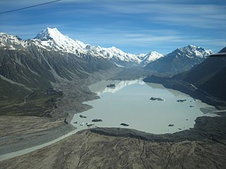
Glaciers cover 40% of the park area, notably the Tasman Glacier in the Tasman Valley east of Aoraki / Mount Cook.[1] Eight of the twelve largest glaciers in New Zealand lie within Aoraki/Mount Cook National Park, all of which terminate at proglacial lakes formed in recent decades due to a sustained period of shrinking.[5]
Haupapa / Tasman Glacier is the largest glacier in New Zealand, and one of several large glaciers which flow south and east towards the Mackenzie Basin from the Southern Alps in New Zealand's South Island.
A glacier terminus, toe, or snout, is the end of a glacier at any given point in time. Although glaciers seem motionless to the observer, in reality glaciers are in endless motion and the glacier terminus is always either advancing or retreating. The location of the terminus is often directly related to glacier mass balance, which is based on the amount of snowfall which occurs in the accumulation zone of a glacier, as compared to the amount that is melted in the ablation zone. The position of a glacier terminus is also impacted by localized or regional temperature change over time.
In geology, a proglacial lake is a lake formed either by the damming action of a moraine during the retreat of a melting glacier, a glacial ice dam, or by meltwater trapped against an ice sheet due to isostatic depression of the crust around the ice. At the end of the last ice age about 10,000 years ago, large proglacial lakes were a widespread feature in the northern hemisphere.
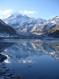
In the area surrounding Aoraki / Mount Cook, the Tasman Glacier, Hooker Glacier, Murchison Glacier, and Mueller Glacier all terminate in lakes, while further north in the park, the Godley Glacier, Classen Glacier, Grey Glacier and Maud Glacier also end in proglacial lakes. Tasman Lake and Hooker Lake are easily accessible via walking tracks and are the only two of these lakes that have official names. At an area of 7km², Tasman Lake is the largest of the proglacial lakes and hosts boat trips for tourists.[6][7]
Hooker Glacier is one of several glaciers close to the slopes of Aoraki / Mount Cook in the Southern Alps of New Zealand. It is not as large as its neighbour, the Tasman Glacier, measuring 11 kilometres in length.
The Murchison Glacier is an 18-kilometre (11 mi) long glacier flowing through Aoraki/Mount Cook National Park in the South Island of New Zealand. Lying to the east of the Malte Brun range and west of the Liebig Range, high in the Southern Alps, it flows from the Tasman Saddle at 2,435 m mostly southwestwards to around 1,110 m. The Murchison River, which takes its meltwater, flows under the larger Tasman Glacier to the south.
The Mueller Glacier is a 13-kilometre (8.1 mi) long glacier flowing through Aoraki/Mount Cook National Park in the South Island of New Zealand. It lies to the south of Aoraki/Mount Cook, high in the Southern Alps, and flows north. Its meltwaters eventually join the Tasman River.
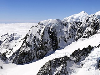
Of New Zealand's 20 peaks over 3,000 metres, all except Mount Aspiring / Tititea lie in the park.[8] These include New Zealand's highest mountain, Aoraki / Mount Cook, at 3,724 metres. Other prominent peaks include Mt Tasman, Mt Hicks, Mt Sefton and Mt Elie de Beaumont. The mountains of the Southern Alps in general are young, less than ten million years old, and are still building. Uplift in the region of the national park is at the rate of 5–10mm per year. It's estimated that approximately 25km of uplift has occurred, however the rate of uplift has been countered by erosion.[9]
Mount Aspiring / Tititea is New Zealand's 23rd-highest mountain. It is the country's highest outside the Aoraki / Mount Cook region.
Mount Tasman is New Zealand's second highest mountain, rising to a height of 3,497 metres (11,473 ft). It is located in the Southern Alps of the South Island, four kilometres to the north of its larger neighbour, Aoraki / Mount Cook. Unlike Aoraki / Mount Cook, Mount Tasman sits on the South Island's Main Divide, on the border between Aoraki/Mount Cook National Park and Westland Tai Poutini National Park. It is the highest point in Westland District.
Mount Sefton is a mountain in the Aroarokaehe Range of the Southern Alps of New Zealand, just 12 kilometres (7.5 mi) south of Aoraki / Mount Cook. To the south lies Mount Brunner, and to the north The Footstool, both more than 400 metres (1,300 ft) shorter.
Mount Cook Buttercups with Lake Hooker in the background
More than 400 species of plants make up the vegetation in Aoraki/Mount Cook National Park, which include more than 100 introduced plant species such as the colourful Russell lupin, the wild cherry and wilding pines. Under normal circumstances, forest grows to about 1,300m, however, most parts of the park are either at higher altitudes above the tree line or in the proglacial valleys such as the Hooker Valley and Tasman Valley, where the rocky soil of the valley floors and moraine walls do not support forest growth. As a result, the only pockets of forest and native bush in the park are along the southern edge of the Hooker Valley and the lower slopes of Sealy Range.[10]
The plant life in the majority of the park consists mostly of alpine plants. Between 1,300m and 1,900m and in the valleys, the vegetation is predominately snow tussock grassland, as well as golden speargrass, large mountain daisies/tikumu (Celmisia semicordata, Celmisia coriacea), and Mount Cook lily, (Ranunculus lyallii), the largest buttercup in the world.[1] All of these plants flower in the warmer months from November to February – early in the season in the valley floors, and late at higher altitudes. At the highest rocks of Aoraki / Mount Cook, around 14 species of lichen have been found.[11]
The native vegetation continues to be under threat by introduced plant species ranging from non-native trees through to lupins, broom and non-native grasses. These are mostly contained in the valley floors of the Tasman and Hooker Valley, since they are the most accessible parts of the park.[12]
There are about 35[13] to 40 species of birds in the park and include the kea, the only alpine parrot, and the well-camouflaged pipit. The tiny rock wren/pïwauwau, a threatened species, is the only permanent resident high on the mountains.[13] It is unrelated to the rock wren of North America. Small insectivores such as the riflemen/tïtitipounamu and the New Zealand fantails/pïwakawaka live in the low forest and scrub, along with small numbers of two larger birds, the wood pigeon and morepork. Introduced species such as finches and sparrows live throughout the bush near Mount Cook Village. The black stilt or kakī, rarest wading bird in the world, lives in the braided riverbed of the Tasman.[1]
The park is home to many invertebrates, including large dragonflies, crickets, grasshoppers, 223 recorded moth species and 7 native butterflies.[14] A black alpine weta, also known as the Mount Cook flea is found above the snowline. The jewelled gecko lives in the park but is rarely seen.[1] Introduced red deer, chamois and Himalayan tahr can be hunted.[15]
Mount Cook Village in front of Aroarokaehe Range, in summerFrozen Mueller Glacier lake in winter
Climate
Temperatures in Mount Cook Village range from −13°C (9°F) to 32°C (90°F), and typically fall just over 1°C for every 200 metres of altitude.[16]
Rainfall is similarly variable, with the driest months receiving around 300mm (12in) precipitation per month, but recorded maxima of 537mm (21.1in) in one day and 1,447mm (57.0in) in a single month. Snow falls on about 21 days per year.[16]
During the coldest months of the year, Mueller Glacier Lake, Hooker Lake, and Tasman Lake usually freeze over at least partially.
The weather conditions in the park, in particular at higher altitudes can be unpredictable and change rapidly.[17] Anyone venturing further than the walking tracks is strongly advised to notify their intentions at the Visitor Centre on the day you start. This is part of a formal intentions process that operates in the park and is used to initiate formal search operations.[18]
Climate data for Mount Cook Village, New Zealand (1981–2010)
Mount Cook Village is the start of several walks ranging from easy walking tracks such as the popular Hooker Valley Track to tramping tracks like the steep track to the Sealy Tarns. Some of these tracks also offer guided walking tours, and the nearby Tasman Lake hosts boat trips for tourists.[21] The park contains close to twenty huts, mostly in alpine terrain. The huts range from basic shelters to serviced huts, with the most accessible hut being Mueller Hut, which can be reached from Mount Cook Village within 4 hours.[18]
A visitor centre in the village features interpretation exhibits about the area's natural environment and history as well as an artwork collection.[22]
Mountaineering
Aoraki / Mount Cook, from Tasman Lake
The spectacular peaks of the Aoraki / Mount Cook region have attracted climbers from all over the world for the last 100 years. The dramatic nature of these mountains provides a rare challenge. The combination of heavy glaciation, tremendous vertical scale and unpredictable weather means that they are not readily won. To climb successfully here requires skill, fitness, patience, and a great respect for the mountains. Mountaineering on the Aoraki / Mount Cook massif is a hazardous activity.[23]
Other mountaineering routes include crossing the Aroarokaehe Range via the Copland Pass, the Mount Cook Range via the Ball Pass, and routes crossing the Tasman Saddle further north. All of these routes still require significant alpine mountaineering experience.
On the opposite side of the Hooker Valley, Mt Ollivier was Sir Edmund Hillary's first major climb, in 1939, and since the establishment of a tramping track to Mueller Hut, not far below the summit, is now one of the easiest accessible mountains in the park.
Another mountain popular for mountaineers of intermediate skills is Sebastopol, the closest mountain to Mount Cook Village. At 1,468m height, it is only 750m above Mount Cook Village, with the lower half of the ascent following the Red Tarns tramping track.[24] Sebastopol offers one of few view points taking in both the Hooker Valley and the Tasman Valley.
Area history
Icebergs in Tasman Lake. Aoraki / Mount Cook in the background
At the end of the most recent ice age, around 13,000 years ago,[25] the Mueller Glacier, Hooker Glacier, and Tasman Glacier were all tributaries to a much larger glacier covering all of Hooker Valley and Tasman Valley in hundreds of metres of ice and reaching as far as the extent of today's Lake Pukaki,[26] up to 40km (25mi) south of Aoraki / Mount Cook National Park.
As the glacier retreated, it filled the hollowed out valleys with rocks and gravel, leaving behind the flat-bottomed valleys seen today.
1642 – Aoraki possibly sighted by Abel Tasman and crew members[27]
1770 – Captain Cook named the Southern Alps
1851 – Captain Stokes of the survey ship HMS Acheron gave the name Mount Cook to Aoraki
1884 – First Hermitage built under the direction of Frank Huddleson
1991 – Avalanche of 10 million cubic metres of snow and rock causes 10 metres to be lost off the top of Aoraki / Mount Cook[28][29] Two decades of erosion of the ice cap exposed after this collapse reduced the height by another 30m to 3,724m, as revealed by new GPS data from a University of Otago climbing expedition in November 2013.[30][31]
1998 – The Ngāi Tahu Claims Settlement Act officially recognises the original name, renaming the mountain Aoraki / Mount Cook[32]
Transport
Rodolph Wigley's Mount Cook Motor Co was formed in 1906 to provide services to the area from the railhead at Fairlie.[33] A small airfield, Mount Cook Aerodrome, 5km (3.1mi) southeast of Mount Cook Village has been served by the Wigley family's New Zealand Aero Transport Company and successor Mount Cook Airline sporadically since 1921.
Road access into the park is via State Highway 80, along the western shore of Lake Pukaki. The road ends at Mount Cook Village, with a connecting road leading to the White Horse Hill camping ground. Another small road leads to a car park near Tasman Lake, the start of a short walking track and the Ball Hut Route.
Aoraki/Mount Cook National Park is the starting point of the Alps to Ocean Cycle Trail to Oamaru. The 300kilometre cycle trail has been constructed from 2010 onwards by the New Zealand Cycle Trail project. As of 2016[update] the cycle trail still includes 15kilometres along public roads.[34]
Aoraki / Mount Cook is the highest mountain in New Zealand. Its height since 2014 is listed as 3,724 metres, down from 3,764 m (12,349 ft) before December 1991, due to a rockslide and subsequent erosion. It lies in the Southern Alps, the mountain range which runs the length of the South Island. A popular tourist destination, it is also a favourite challenge for mountain climbers. Aoraki / Mount Cook consists of three summits, from South to North the Low Peak, Middle Peak and High Peak. The summits lie slightly south and east of the main divide of the Southern Alps, with the Tasman Glacier to the east and the Hooker Glacier to the southwest.
Te Wāhipounamu is a World Heritage Site in the south west corner of the South Island of New Zealand.
Lake Pukaki is the largest of three roughly parallel alpine lakes running north-south along the northern edge of the Mackenzie Basin on New Zealand's South Island. The others are Lakes Tekapo and Ohau. All three lakes were formed when the terminal moraines of receding glaciers blocked their respective valleys, forming moraine-dammed lakes.
Aoraki / Mount Cook, often referred to as Mount Cook Village, is located within New Zealand's Aoraki/Mount Cook National Park at the end of State Highway 80, only 15 kilometres (9.3 mi) south of the summit of the country's highest mountain, also called Aoraki / Mount Cook, in the Southern Alps.
The Tasman River is an alpine braided river flowing through Canterbury, in New Zealand's South Island.
Mackenzie District is a local government district in New Zealand's South Island administered by the Mackenzie District Council. It is part of the larger Canterbury region.
Mount Cook Group was a New Zealand tourism and transport operator founded on 2 April 1912 by Rodolph Lysaght Wigley. Originally a road transport business, the Mount Cook Tourist Company of New Zealand became a public company in 1928. By 1930 Wigley had built it into the largest tourist organisation in New Zealand, and it was renamed Mount Cook and Southern Lakes Tourist Company, the name adopted in the mid 1930s. In 1976 it became The Mount Cook Group Ltd. The company was split in 1989 with various operations progressively sold off, with Air New Zealand retaining the airline businesses. The company remained until 17 June 2013 when it was amalgamated into Air New Zealand Associated Companies Limited, a holding company for Air New Zealand's various businesses.
Tasman Lake is a proglacial lake formed by the recent retreat of the Tasman Glacier in New Zealand's South Island.
Sealy Tarns is a small flat area with two small tarns halfway up the northern slopes of the Sealy Range. It is accessible from the Hooker Valley and Mount Cook Village via a tramping track maintained by the Department of Conservation (DOC). The track climbs steeply from about 850 m (2,789 ft) to 1,300 m (4,265 ft) via many switchbacks and over 2,200 steps built of large timber anchored into the ground. The track was established during the 1980s, and upgraded in 2012. The distance for a return trek from Hooker Valley Road to Sealy Tarns is 5.8 km.
The Hooker River is a river in the Southern Alps of New Zealand. It flows south from Hooker Lake, the glacier lake of Hooker Glacier, which lies on the southern slopes of Aoraki/Mount Cook. After 3 kilometers, it flows through Mueller Glacier Lake, gathering more glacial water, before joining the braided streams of the Tasman River, also an outflow of a glacier lake.
Malte Brun is the highest peak in the Malte Brun Range, which lies between the Tasman and Murchison Glaciers within New Zealand's Southern Alps. According to Land Information New Zealand, it rises to a height of 3,199 metres (10,495 ft), although other sources give heights ranging from 3155 to 3199 m. A list published by the New Zealand Alpine Club ranks Malte Brun as the third highest mountain in New Zealand.
Mount Hicks is a mountain in the Southern Alps in Aoraki/Mount Cook National Park on the South Island of New Zealand. The mountain is 3,216 metres (10,551 ft) high. It is above the Hooker Glacier, in the vicinity of Mount Cook.
The Copland Pass is an alpine pass in the Southern Alps of New Zealand. Known as Noti Hinetamatea by the indigenous Ngāi Tahu, the pass follows the route of the Makaawhio ancestor Hinetamatea and her sons Tātāwhākā and Marupeka.
La Perouse, originally called Mount Stokes, is a mountain in New Zealand's Southern Alps, rising to a height of 3,078 metres (10,098 ft).
Hooker Lake is a proglacial lake that started to form in the late 1970s by the recent retreat of the Hooker Glacier. It is located in the Hooker Valley, within the Aoraki/Mount Cook National Park in New Zealand's South Island, just south of Aoraki / Mount Cook.
The Hooker Valley Track is the most popular short walking track within the Aoraki/Mount Cook National Park in New Zealand. At only 5 kilometres (3.1 mi) length and gaining only about 100 m (330 ft) in height, the well formed track can be walked by tourists with a wide range of level of fitness.
↑ . The landslide carried with it another 40million cubic metres of rock and ice.The impact caused an earth quake of 3.9 on the Richter scale. <P207 in search of Ancient NZ.Campball and Hutching.GNS science/Penguin.2011.> Michael J. Crozier. "Mt Cook landslide". Te Ara: The Encyclopedia of New Zealand. Retrieved 3 May 2007.
This page is based on this Wikipedia article Text is available under the CC BY-SA 4.0 license; additional terms may apply. Images, videos and audio are available under their respective licenses.