
Colombia is a unitary republic made up of thirty-two departments and a Capital District. Each department has a governor (gobernador) and an Assembly, elected by popular vote for a four-year period. The governor cannot be re-elected in consecutive periods. Departments are country subdivisions and are granted a certain degree of autonomy.

Cauca Department is a Department of Southwestern Colombia. Located in the southwestern part of the country, facing the Pacific Ocean to the west, the Valle del Cauca Department to the north, Tolima Department to the northeast, Huila Department to the east, and Nariño Department to the south. Putumayo and Caqueta Departments border the southeast portion of Cauca Department as well. It covers a total area of 29,308 km2 (11,316 sq mi), the 13th largest in Colombia. Its capital is the city of Popayán. The offshore island of Malpelo belongs to the department. It is located in the southwest of the country, mainly in the Andean and Pacific regions plus a tiny part (Piamonte) in the Amazonian region. The area includes 2.56% of the country.

Risaralda is a department of Colombia. It is located in the western central region of the country and part of the Paisa Region. Its capital is Pereira.
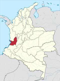
Valle del Cauca, or Cauca Valley, is a department of Western Colombia. It is on the western side of the country, abutting the Pacific Ocean. Its capital is Santiago de Cali. Such other cities as Buenaventura, Buga, Valle del Cauca, Cartago, Palmira, Valle del Cauca and Tuluá have great economical, political, social and cultural influence on the department's life. Valle del Cauca has the largest number of independent towns with over 100,000 inhabitants in the country, counting six within its borders. Buenaventura has the largest and busiest seaport in Colombia, moving about 8,500,000 tons of merchandise annually.

Vaupés is a department of Southeastern Colombia in the jungle covered Amazonas Region. It is located in the southeast part of the country, bordering Brazil to the east, the department of Amazonas to the south, Caquetá to the west, and Guaviare, and Guainía to the north; covering a total area of 54,135 km². Its capital is the town of Mitú.

Zarzal is a town and municipality in the north of the department of Valle del Cauca in Colombia. Its economy is based primarily on the extensive cultivation of sugar cane, on small and medium enterprises in the metallurgic sector, and on utilities. Commerce is also of great importance, because a great number of warehouses for basic necessity goods exist in the city. A marketplace also exists, which serves as reference for various cities that are close by. Zarzal has a population of about 50,000 inhabitants. New city districts were constructed in the center of the city; it has now become difficult to find bare land inside the city.

Santa Fe de Antioquia is a municipality in the Antioquia Department, Colombia. The city is located approximately 58 kilometres (36 mi) north of Medellín, the department capital. It has a population of approximately 23,000 inhabitants.

Caucasia is a municipality located in the subregion of Bajo Cauca Antioquia department, in Colombia. Bounded on the south by the department of Córdoba, in the east by the municipalities of Antioquia in Nechí and El Bagre, on the north by the municipality of Zaragoza, and west to the town of Cáceres, and is located 270 km from Medellín.
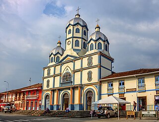
Filandia is a town and municipality in the northern part of the department of Quindío, Colombia. It is located on the west side of Cordillera Central of the Andes mountain range running through central Colombia, 26 km north of the departmental capital Armenia. It is the northernmost of twelve municipalities that form Quindío, the second smallest department of Colombia. It houses a small community economically supported by agriculture and tourism.

Piamonte is a town and municipality in the Cauca Department, Colombia.

San José del Palmar is a municipality and town in the Chocó Department, Colombia in the central part of the country, 240 km west of the capital Bogotá. San José del Palmar is 1,288 meters above sea level and the population is about 4,800.
Almaguer is a town and municipality in the Cauca Department, Colombia.

Balboa is a town and municipality in the Cauca Department, Colombia.
Bolívar is a town and municipality in the Cauca Department, Colombia. Founded in October 1784 by Domingo Belisario Gómez, the municipality covers an area of 746.3 km (464 mi) and has a population of 57,511. The population is primarily engaged in agriculture and ranching.

Buenos Aires is a town and municipality in the Cauca Department, Colombia. Founded in by Vasco de Guzmán and Alonso de Fuenmayor in 1551, the municipality covers an area 520 km2 (201 sq mi) and has a population of 21,300. The population is primarily engaged in agriculture and ranching.

Guapi is a town and municipality in the Cauca Department, Colombia. The municipality of Guapi is located on the Guapi River four miles away from the Pacific Ocean and also covers the island of Gorgona. The town is rich in diversity and the only way to get there is by flying from Cali or sailing. The town counts with cinema, great view of the river and many natural entertainments. The people are very friendly and welcoming, most of the locals live off fishing.
The Laguna de Sonso Nature Reserve is located in the Valle del Cauca Department of Colombia. It contains the last extensive remnant of original natural wetland remaining in the Cauca River Valley in western Colombia, and was declared a nature reserve in October 1978. It comprises a series of marshes and lagoons on the east bank of the Cauca River, between the municipalities of Buga, Yotoco and Guacari. It has an area of 2,045 ha (7.90 sq mi), lying at an altitude of 935 m (3,068 ft). The wetlands are affected by the introduced water hyacinth. The reserve has been designated as a protected Ramsar site since 2017.

Yotoco is a town and municipality located in the Department of Valle del Cauca, Colombia.

San Andrés is a town and municipality in Antioquia Department, Colombia. Part of the subregion of Northern Antioquia.


