Arkha अर्खा | |
---|---|
Village Development Committee | |
Coordinates: 28°16′N83°04′E / 28.27°N 83.07°E | |
Country | |
Region | Mid-Western |
Zone | Rapti Zone |
District | Pyuthan District |
VDC | Arkha |
Population (2001 Census [1] ) | |
• Total | 3,331 |
581 households | |
Time zone | Nepal Time (UTC+5:45) |
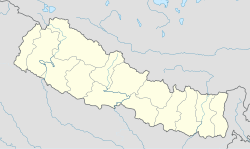
Arkha is a Village Development Committee in Pyuthan, a Middle Hills district of Rapti Zone, western Nepal.
Pyuthan District (Nepali: प्युठान जिल्ला
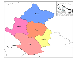
Rapti Zone was one of the fourteen zones, located in the Mid-Western Development Region of Nepal. It was named after the West Rapti River which drains Rolpa, Pyuthan and part of Dang districts. The remainder of Dang and part of Salyan district are drained by the Babai. The remainder of Salyan and all of Rukum districts are drained by the Bheri.
Nepal, officially the Federal Democratic Republic of Nepal, is a landlocked country in South Asia. It is located mainly in the Himalayas but also includes parts of the Indo-Gangetic Plain. With an estimated population of 26.4 million, it is 48th largest country by population and 93rd largest country by area. It borders China in the north and India in the south, east, and west while Bangladesh is located within only 27 km (17 mi) of its southeastern tip and Bhutan is separated from it by the Indian state of Sikkim. Nepal has a diverse geography, including fertile plains, subalpine forested hills, and eight of the world's ten tallest mountains, including Mount Everest, the highest point on Earth. Kathmandu is the nation's capital and largest city. Nepal is a multiethnic nation with Nepali as the official language.
Ward | Lat. | Lon | Elev. | ||
---|---|---|---|---|---|
Artubang | अर्टुबाङ | 9 | 28°15'N | 83°02'E | 1,625m |
Banyachaur | बाँयचौर | 28°16'N | 83°04'E | 1,670 | |
Bas | बास | 28°17'N | 83°04'E | 2,058 | |
Besiban | बेसिबन | 28°16'N | 83°04'E | 1,788 | |
Bhande Khoriya | भाँडे खोरिया | 28°15'N | 83°04'E | 2,030 | |
Bhulke | भुल्के | 28°15'N | 83°05'E | 2,199 | |
Damremela | दाम्रेमेला | 28°15'N | 83°05'E | 2,120 | |
Dandagaun | डाँडागाउँ | 28°16'N | 83°04'E | 1,790 | |
Dhungmang | ढुङमाङ | 28°16'N | 83°05'E | 2,031 | |
Galangchhang | गलाङछाङ | 28°15'N | 83°04'E | 1,858 | |
Harji | हर्जी | 28°16'N | 83°05'E | 2,145 | |
Lamadanda | लामाडाँडा | 28°16'N | 83°03'E | 1,540 | |
Lamagaun | लामागाउँ | 28°15'N | 83°03'E | 1,890 | |
Lekhachhar | लेखाछार | 28°17'N | 83°03'E | 2,170 | |
Lujbang | लुजबाङ | 28°17'N | 83°03'E | 1,750 | |
Majuwa | मजुवा | 28°16'N | 83°03'E | 1,470 | |
Mathillo sungure | माथिल्लो सुङ्गुरे | 28°17'N | 83°05'E | 2,270 | |
Painyapata | पैंयापाटा | 6 | 28°16'N | 83°04'E | 1,670 |
Patal | पातल | 28°15'N | 83°03'E | 2125 | |
Pokhari Bhitta | पोखरी भिट्टा | 28°15'N | 83°03'E | 1,975 | |
Rangjung | राङजुङ | 28°15'N | 83°05'E | 1,965 | |
Sagbari | सागबारी | 28°16'N | 83°05'E | 1,942 | |
Saura | सौरा | 28°16'N | 83°03'E | 1,530 | |
Sebini | सेबिनी | 28°15'N | 83°03'E | 2,070 | |
Sokhu | सोखु | 28°17'N | 83°05'E | 2,021 | |
Sungure | सुङ्गुरे | 28°16'N | 83°04'E | 1,750 | |
Thatrapatal | थात्रापातल | 28°15'N | 83°03'E | 1,818 | |
Thula Kharka | ठूला खर्क | 28°15'N | 83°02'E | 1,290 | |
Thulo Chaur | ठूलो चौर | 1 | 28°17'N | 83°04'E | 1,670 |
Baraula is a town and Village Development Committee in Pyuthan, a Middle Hills district of Rapti Zone, western Nepal.
Barjibang is a village and Village Development Committee in Pyuthan, a Middle Hills district of Rapti Zone, western Nepal.
Bhingri is a Village Development Committee in Pyuthan, a Middle Hills district of Rapti Zone, western Nepal.
Bijuli is a town and Village Development Committee in Pyuthan, a Middle Hills district of Rapti Zone, western Nepal.
Chunja is a town and Village Development Committee in Pyuthan, a Middle Hills district of Rapti Zone, western Nepal.
Damri is a town and Village Development Committee in Pyuthan, a Middle Hills district of Rapti Zone, western Nepal.
Dangbang is a town and Village Development Committee in Pyuthan, a Middle Hills district of Rapti Zone, western Nepal.
Dharampani is a village and Village Development Committee in Pyuthan, a Middle Hills district of Rapti Zone, western Nepal.
Dhubang is a town and village development committee in Pyuthan, a Middle Hills district of Rapti Zone, western Nepal.
Jumrikanda is a town and Village Development Committee in Pyuthan, a Middle Hills district of Rapti Zone, western Nepal.
Khabang is a town and Village Development Committee in Pyuthan, a Middle Hills district of Rapti Zone, western Nepal.
Khung is a village and Village Development Committee in Pyuthan District in Pyuthan, a Middle Hills district of Rapti Zone, western Nepal.
Kochibang is a village and Village Development Committee in Pyuthan, a Middle Hills district of Rapti Zone, western Nepal.
Ligha also known as Lipa is a village and Village Development Committee in Pyuthan, a Middle Hills district of Rapti Zone, western Nepal.
Libang is a town and Village Development Committee in Pyuthan, a Middle Hills district of Rapti Zone, western Nepal.
Lung is a town and Village Development Committee in Pyuthan, a Middle Hills district of Rapti Zone, western Nepal.
Bangemarot is a Village Development Committee in Pyuthan, a Middle Hills district of Rapti Zone, western Nepal.
Maranthana is a town and market center in Pyuthan Municipality in Pyuthan, a Middle Hills district of Rapti Zone, western Nepal. The formerly Village Development Committee along with Pyuthan Khalanga, Bijubar, Dakha Kwadi, Bijaya Nagar, Dharmawati, Maranthana and Khaira was merged to form the new municipality since 18 May 2014.
Markabang is a village and Village Development Committee in Pyuthan, a Middle Hills district of Rapti Zone, western Nepal.
Torbang is a town and Village Development Committee in Pyuthan, a Middle Hills district of Rapti Zone, western Nepal.