
Leigh Creek is a former coal-mining town in eastern central South Australia. At the 2016 census, Leigh Creek had a population of 245, a 55% decrease from 550 in the previous census in 2011.

South East Queensland (SEQ) is a bio-geographical, political, and administrative region of the state of Queensland in Australia, which contains 3.5 million people out of the state's population of 4.8 million. The area covered by South East Queensland varies, depending on the definition of the region, though it tends to include Queensland's three largest cities: the capital city Brisbane; the Gold Coast; and the Sunshine Coast. Its most common use is for political purposes, and covers 22,420 square kilometres (8,660 sq mi) and incorporates 11 local government areas, extending 240 kilometres (150 mi) from Noosa in the north to the Gold Coast and New South Wales border in the south, and 140 kilometres (87 mi) west to Toowoomba.

The Stanley River is a perennial river located in the South East region of Queensland, Australia. A major tributary of the Brisbane River, the Stanley River valley extends roughly 35 kilometres (22 mi) westwards from the area south of Maleny, through Woodford to Kilcoy before veering southwards.

The Somerset Dam is a mass concrete gravity dam with a gated spillway across the Stanley River in Queensland, Australia. It is within the locality of Somerset Dam in the Somerset Region in South East Queensland. The main purpose of the dam is the supply of potable water for the Brisbane, Gold Coast and Logan City regions. Additionally, the dam provides for flood mitigation, recreation and for the generation of hydroelectricity. The impounded reservoir is called Lake Somerset.

The Lockyer Valley is an area of rich farmlands that lies to the west of Brisbane, Queensland, Australia and east of Toowoomba. The Lockyer Valley is rated among the top ten most fertile farming areas in the world as mentioned in page 13 of the Lockyer Valley Community Recovery Plan 2011. The intensively cultivated area grows the most diverse range of commercial fruit and vegetables of any area in Australia. The valley is referred to as "Australia's Salad Bowl" and has been described as one of Australia's premium food bowls.
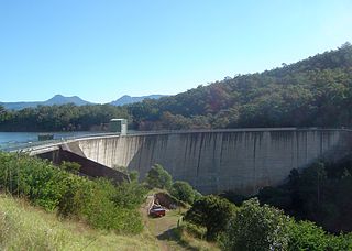
The Moogerah Dam is a mass concrete double curvature arch dam with a un-gated spillway across the Reynolds Creek that is located in the South East region of Queensland, Australia. The main purposes of the dam are for irrigation of the Reynolds Creek and for supply of potable water to Warrill Creek and farmers in the Warrill Valley. The impounded reservoir is called Lake Moogerah.

Kandanga is a town in south east Queensland, Australia. The town is located on the Mary Valley Highway, 160 kilometres (99 mi) north of the state capital, Brisbane and 28 kilometres (17 mi) south west of Gympie, on the banks of Kandanga Creek. Part of the Gympie Region local government area, Kandanga at the 2006 census had a population of 596.
. The name "Kandanga" is derived from the local Kabi Aboriginal language, meaning a fork or sharp bend of the creek.

The Lockyer Creek is a creek located in South East Queensland, Australia. A tributary of the Brisbane River, the creek is a major drainage system in the Lockyer Valley. Rising on the eastern slopes of the Great Dividing Range, the creek flows generally north-easterly for more than 100 kilometres (62 mi) before it reaches its confluence with the Brisbane River north-northeast of Lowood, and downstream from the Wivenhoe Dam. The creek is named after Edmund Lockyer.

The Mary River is a major river system located in the South East and Wide Bay–Burnett regions of Queensland, Australia.

The North Pine Dam is a mass concrete gravity dam with earth-fill embankments on abutments with a gated spillway across the North Pine River that is located in the South East region of Queensland, Australia. The main purpose of the dam is for supply of potable water for the Moreton Bay region and Brisbane's northern suburbs. The impounded reservoir is called Lake Samsonvale.

Coominya is a town and locality in the Somerset Region in South East Queensland, Australia. The town is located 83 kilometres (52 mi) west of the state capital, Brisbane and approximately 2 kilometres (1.2 mi) from Wivenhoe Dam. In the 2011 census, Coominya had a population of 1,174 people.

The Numinbah Valley is a valley and suburb in the Gold Coast hinterland in South East Queensland, Australia. This Scenic Rim valley covers 116 km² and contains cleared grazing land, rocky outcrops, waterfalls, rainforest walks and good hinterland scenery. Lonely Planet has described the valley as the most beautiful in South East Queensland.

The Atkinson Dam is an earth-fill embankment dam across the Buaraba Creek and a naturally forming lagoon, which is located near Lowood in the South East region of Queensland, Australia. The main purpose of the dam is for irrigation of farming land in the lower Lockyer Valley. The resultant reservoir is called Lake Atkinson.

The Bill Gunn Dam is an earth-fill embankment dam with an un-gated spillway located off-stream in the South East region of Queensland, Australia. The main purpose of the dam is for irrigation of the Lockyer Valley. The resultant reservoir is called Lake Dyer.

The Lake Clarendon Dam is a rock and earth-fill embankment dam with an un-gated spillway located off-stream in the locality of Lake Clarendon in the Lockyer Valley Region, South East Queensland, Australia. The main purpose of the dam is for irrigation of the Lockyer Valley. The resultant impounded reservoir is called Lake Clarendon.
The Connolly Dam, also called the Silverwood Dam, is a rock–fill embankment dam with an un–gated spillway across the Rosenthall Creek and the Fitz Creek that is located in the Darling Downs region of Queensland, Australia. The main purpose of the dam is for potable water supply of the Southern Downs Region.

Aroona is a suburb of the Sunshine Coast Region, Queensland, Australia. It is located within the Caloundra urban centre 4 kilometres (2 mi) north-west of Caloundra. It is situated between Little Mountain and Currimundi. At the 2016 Australian Census, the suburb recorded a population of 3,287.

