
The East Coast of the United States, also known as the Eastern Seaboard, the Atlantic Coast, and the Atlantic Seaboard, is the coastline along which the Eastern United States meets the North Atlantic Ocean. The coastal states that have shoreline on the Atlantic Ocean are, from north to south, Maine, New Hampshire, Massachusetts, Rhode Island, Connecticut, New York, New Jersey, Delaware, Maryland, Virginia, North Carolina, South Carolina, Georgia, and Florida.

Vinton County is a county located in the U.S. state of Ohio. As of the 2010 census, the population was 13,435, making it the least populous county in the state. Its county seat is McArthur. The county is named for Samuel Finley Vinton, US Representative from Ohio.

Middlesboro is a home rule-class city in Bell County, Kentucky, United States. The population was 10,334 at the 2010 U.S. census, while its micropolitan area had a population of 69,060.
An IATA airport code, also known as an IATA location identifier, IATA station code or simply a location identifier, is a three-letter code designating many airports around the world, defined by the International Air Transport Association (IATA). The characters prominently displayed on baggage tags attached at airport check-in desks are an example of a way these codes are used.

Port Arthur is a city in Jefferson County within the Beaumont–Port Arthur metropolitan area of the U.S. state of Texas. A small portion extends into Orange County. It is 90 mi (140 km) east of Houston. It is host to the largest oil refinery in the United States.

Long Island MacArthur Airport is a public airport in Ronkonkoma, New York on Long Island. The Town of Islip owns and operates the airport, which serves about two million commercial passengers a year, as well as general aviation. Long Island MacArthur Airport (LIMA) covers 1,311 acres and has four runways and two helipads.

The ICAO airport code or location indicator is a four-letter code designating aerodromes around the world. These codes, as defined by the International Civil Aviation Organization and published in ICAO Document 7910: Location Indicators, are used by air traffic control and airline operations such as flight planning.

Operation Yellow Ribbon was commenced by Canada to handle the diversion of civilian airline flights in response to the September 11 attacks in 2001 on the United States. Canada's goal was to ensure that potentially destructive air traffic be removed from United States airspace as quickly as possible, and away from potential U.S. targets, and instead place these aircraft on the ground in Canada, at military and civilian airports in the Canadian provinces of Nova Scotia, Newfoundland and Labrador, and British Columbia where any destructive potential could be better contained and neutralized. None of the aircraft proved to be a threat, and Canada and Canadians hosted thousands of passengers stranded in Canada until U.S. airspace was reopened.
An airport is a location where aircraft take off and land.
Airport may also refer to:
A location identifier is a symbolic representation for the name and the location of an airport, navigation aid, or weather station, and is used for manned air traffic control facilities in air traffic control, telecommunications, computer programming, weather reports, and related services.

U.S. Naval Air Station Cubi Point was a United States Navy aerial facility located at the edge of Naval Base Subic Bay and abutting the Bataan Peninsula in the Republic of the Philippines.
Jumbolair Airport is a private-use airport. It is located in the unincorporated community of Anthony, which is seven miles (11 km) northeast of Ocala, Florida, United States. Frank Merschman owns and operates Jumbolair. The airport has two runways: 18/36 with an asphalt pavement measuring 7,550 x 210 ft and 9/27 with a grass surface measuring 3,640 x 100 ft. According to FAA documents, 9/27 ""Greystone"" grass airstrip was once so degraded that only the smallest aircraft could use it.

Reao or Natūpe is an atoll in the eastern expanses of the Tuamotu group in French Polynesia. The closest land is Pukarua Atoll, located 48 km to the WNW.

Terrell Municipal Airport is a public access airport located within the city limits of Terrell, Texas, 1 mile SE of central Terrell.
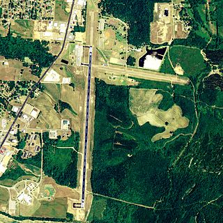
Richard Arthur Field is a city-owned public-use airport located three nautical miles northeast of the central business district of Fayette, a city in Fayette County, Alabama, United States.
Arthur Dunn Airpark is a public-use airport located 2 miles (3.2 km) northwest of the central business district of the city of Titusville in Brevard County, Florida, United States. The airport is publicly owned and is administered under the cognizance of the Titusville-Cocoa Airport Authority. The airport has one paved runway that is 2,961 feet in length and a turf runway that is 1,805 feet in length.
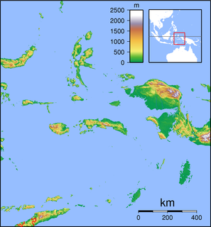
Leo Wattimena Airport, formerly known as Pitu Airport is a private airport located on the southern coast of Morotai Island, North Maluku, Indonesia.

ExcelAire, LLC is a United States air charter company based at Long Island MacArthur Airport in Ronkonkoma, New York. ExcelAire LLC specializes in worldwide jet and helicopter charters, aircraft management, maintenance and aircraft sales.
Elite Airways is an airline based in the United States operating charter and scheduled passenger flights. The airline is a relatively new carrier that adjusts destinations as demand increases or decreases. The airline is headquartered in Portland, Maine.
