Ashdale, Nova Scotia

Last updated
Canada Nova Scotia location map 2.svg
Red pog.svg
Ashdale in Nova Scotia

Ashdale is a small community in the Canadian province of Nova Scotia, located in Antigonish County. [1] It is on Nova Scotia Trunk 7, approximately 13km south of Antigonish, at an elevation around 100m. [2] It was formerly known as Collegeville and an Environment Canada weather station in the community retains the name Collegeville. The Collegeville post office was opened on June 1, 1887 and closed February 29, 1932.

Canada Country in North America

Canada is a country in the northern part of North America. Its ten provinces and three territories extend from the Atlantic to the Pacific and northward into the Arctic Ocean, covering 9.98 million square kilometres, making it the world's second-largest country by total area. Its southern border with the United States, stretching some 8,891 kilometres (5,525 mi), is the world's longest bi-national land border. Canada's capital is Ottawa, and its three largest metropolitan areas are Toronto, Montreal, and Vancouver.

Nova Scotia Province of Canada

Nova Scotia is one of Canada's three Maritime Provinces, and one of the four provinces that form Atlantic Canada. Its provincial capital is Halifax. Nova Scotia is the second-smallest of Canada's ten provinces, with an area of 55,284 square kilometres (21,300 sq mi), including Cape Breton and another 3,800 coastal islands. As of 2016, the population was 923,598. Nova Scotia is Canada's second-most-densely populated province, after Prince Edward Island, with 17.4 inhabitants per square kilometre (45/sq mi).

Antigonish County, Nova Scotia County in Nova Scotia, Canada

Antigonish County is a county in the province of Nova Scotia, Canada. It is located in northern Nova Scotia on the Northumberland Strait. The Town of Antigonish and Municipality of the County of Antigonish are the two largest incorporated municipalities in the county.


Related Research Articles

Arisaig, Nova Scotia human settlement in Antigonish County, Nova Scotia, Canada

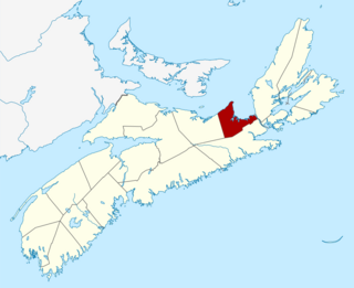
Arisaig, is a small village in Antigonish County, Nova Scotia, Canada. It is located on the north coast of eastern mainland Nova Scotia, on the Northumberland Strait, and is connected to the town of Antigonish to the southeast and to New Glasgow to the west by Route 245, the "Sunrise Trail". Nearby communities include Doctors Brook, Malignant Cove, Knoydart, and McArras Brook.

Caledonia Mills human settlement in Nova Scotia, Canada

Caledonia Mills is a community in the Canadian province of Nova Scotia, located in Antigonish County.

Aulds Cove human settlement in Nova Scotia, Canada

Aulds Cove is a community in the Canadian province of Nova Scotia, located in both Antigonish County and Guysborough County.

Cape George, Nova Scotia human settlement in Nova Scotia, Canada

Cape George is a cape in Antigonish County, Nova Scotia, Canada. It defines the northwestern limit of St. George's Bay. The communities of Cape George, Cape George Point, Morar and Livingstone Cove are situated on the cape.

Malignant Cove, Nova Scotia human settlement in Nova Scotia, Canada

Malignant Cove is a small community in the Canadian province of Nova Scotia, located in Antigonish County. It was named for the sailing vessel Malignant, which ran aground there during the American Revolution. It was renamed Milburn in 1915 but the new name was not adopted by the community. The founder of The Casket, John Boyd, began as a printer in Malignant Cove.

Georgeville, Nova Scotia human settlement in Nova Scotia, Canada

Georgeville is a community on Cape George in Antigonish County, Nova Scotia, Canada.

Doctors Brook human settlement in Canada

Doctors Brook is a small community in the Canadian province of Nova Scotia, located in Antigonish County. It is on Nova Scotia Route 245. It was named for Dr. Alexander MacDonald, the first medical doctor in Antigonish County.

Clydesdale, Nova Scotia human settlement in Nova Scotia, Canada

Clydesdale is a community in the Canadian province of Nova Scotia, located in Antigonish County.

Dunmaglass, Nova Scotia human settlement in Nova Scotia, Canada

Dunmaglass is a locality in the Canadian province of Nova Scotia, located in Antigonish County. Formerly a small community, the use of the name as such was rescinded in 1976. Formerly known as both "back settlement of Knoydart" and "Summerville", it was officially named in 1879 after Dunmaglass, Scotland, the home of its first settlers.

James River, Nova Scotia human settlement in Nova Scotia, Canada

James River is a community in the Canadian province of Nova Scotia, located in Antigonish County.

Antigonish Harbour human settlement in Nova Scotia, Canada

Antigonish Harbour is a community and harbour in the Canadian province of Nova Scotia, located in Antigonish County, first settled in 1784 by disbanded soldiers loyal to the British side in the American Revolution.

McArras Brook General Service Area of Nova Scotia

McArras Brook is a small community in the Canadian province of Nova Scotia, located in Antigonish County. It was named for the original settler, James McCara from Perthshire, Scotland.

Bailey Brook, Nova Scotia human settlement in Nova Scotia, Canada

Bailey Brook, also referred to as Bailey's Brook was a dispersed rural community in the Canadian province of Nova Scotia, located in Pictou County. The name was officially rescinded in 1961. Originally known as Baillies Brook, the area was settled by Scottish immigrants in 1790 and again in 1802. Home of Margaret C. MacDonald.

Addington Forks human settlement in Nova Scotia, Canada

Addington Forks is a rural farming community in the Canadian province of Nova Scotia, located in Antigonish County. It was named for Henry Addington, a British prime minister.

Bayfield, Nova Scotia human settlement in Nova Scotia, Canada

Bayfield is a community in the Canadian province of Nova Scotia, located in Antigonish County. The community is named after Henry Wolsey Bayfield.

Big Marsh, Antigonish County human settlement in Nova Scotia, Canada

Big Marsh is a community in the Canadian province of Nova Scotia, located in Antigonish County.

Brierly Brook human settlement in Nova Scotia, Canada

Brierly Brook is a community in the Canadian province of Nova Scotia, located in Antigonish County. It is named after John Brierly, an early settler, and former soldier who arrived in the area with Lt. Colonel Timothy Hierlihy.

Eigg Mountain mountain in Canada

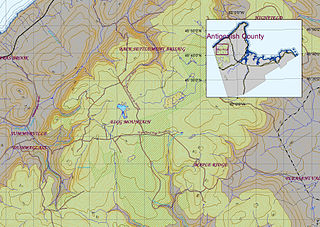
Eigg Mountain is high plateau, part of the highlands of Antigonish County, Nova Scotia, Canada.

Collegeville, Nova Scotia Community in Nova Scotia, Canada

Collegeville is the former name for the community of Ashdale, a community in Antigonish County, Nova Scotia, Canada. It is located roughly 15 kilometres (9.3 mi) southwest of the town of Antigonish. The highest temperature ever recorded in Nova Scotia occurred at the Collegeville climate station, when on 19 August 1935 the mercury climbed to 38.3 °C (100.9 °F).

Arisaig Provincial Park provincial park in Nova Scotia

Arisaig Provincial Park is a provincial park located in Antigonish, Nova Scotia, Canada.

References

  1. Fergusson, C. Bruce (1967). Place-Names and Places of Nova Scotia. Halifax, NS: Public Archives of Nova Scotia. p. 21. Retrieved 16 March 2018.
  2. "Ashdale". Geographical Names Data Base. Natural Resources Canada . Retrieved 16 March 2018.

Coordinates: 45°31′11.35″N62°1′54.83″W / 45.5198194°N 62.0318972°W / 45.5198194; -62.0318972 (Ashdale, Nova Scotia) 3. https://geonova.novascotia.ca/place-names

Geographic coordinate system Coordinate system

A geographic coordinate system is a coordinate system that enables every location on Earth to be specified by a set of numbers, letters or symbols. The coordinates are often chosen such that one of the numbers represents a vertical position and two or three of the numbers represent a horizontal position; alternatively, a geographic position may be expressed in a combined three-dimensional Cartesian vector. A common choice of coordinates is latitude, longitude and elevation. To specify a location on a plane requires a map projection.