Ashley (Bristol ward)

Last updated

Ashley, Bristol
Bristol ashley.png
Boundaries of the council ward, shown within Bristol
Population16,225 (2011.Ward) [1]
OS grid reference ST598755
Unitary authority
Ceremonial county
Region
Country England
Sovereign state United Kingdom
Post town BRISTOL
Postcode district BS6
Dialling code 0117
Police Avon and Somerset
Fire Avon
Ambulance South Western
UK Parliament
Councillors3
Councillors
  • Mike Davies(Labour)
  • Carole Johnson(Labour)
  • Jude English(Green)
List of places
UK
England
Bristol
51°28′26″N2°34′55″W / 51.4739°N 2.5819°W / 51.4739; -2.5819

Ashley is one of thirty-five council wards in the city of Bristol in the United Kingdom. The ward contains the areas of Baptist Mills, Montpelier, St Andrew's, St Paul's and St Werburgh's. [2] The Ward has over 16,000 residents [3] and is served by one community magazine and resident-led organisational body called 'Vocalise'. [4]

Contents

Politics

Ashley is part of the Bristol West parliamentary constituency, which elects one Member of Parliament. The incumbent MP is Thangam Debbonaire of the Labour Party.

Ashley sends three councillors to Bristol City Council. Currently, these are Amirah Cole (Labour), Jude English (Green) and Tim Wye (Green).

Baptist Mills

Baptist Mills is a small area of Bristol, located between St Werburghs and Easton. It was home to a brass works between 1700 and 1840, [5] and a pottery between 1840 and 1891. [6] The area is now often regarded as part of St Werburghs. In the 19th century, part of Baptist Mills was also known as Botany Bay and regarded as a fairly lawless area.

Montpelier

'The Arches' railway bridge is a local landmark on the borders of Montpelier, St Andrews and Cotham. Montpelier railway bridge Bristol.jpg
'The Arches' railway bridge is a local landmark on the borders of Montpelier, St Andrews and Cotham.

Montpelier is an area of North Bristol. It is bounded by Cheltenham Road to the west, St Paul's to the south, St Werburgh's to the east and St Andrew's to the north. It has its own railway station, and a reputation as bohemian. Picton Street is a haven for lovers of organic and vegetarian cuisine.

Previously, Montpelier was carved[ clarification needed ] by French prisoners of war (POWs) from the Napoleonic conflicts. Almost all streets are named after famous generals or have military connotations, such as Wellington, York and Banner Roads. Stories are told of the POWs transporting spoil from the New Cut to lay the foundations for the terrace housing. Original cobble stones laid by the POW's can be seen in the gutters and some secluded alleys.

A view along Picton Street, Montpelier Picton Street.jpg
A view along Picton Street, Montpelier

Picton Street was built and named in honour of Sir Thomas Picton who, as Captain Picton, in 1783 endeared himself to Bristolians by bravely facing the rebellious 75th Regiment on College Green and averting a military mutiny. There is a double-bayed villa in the street named after him, Picton Lodge.

St Andrew's

St Andrew's is a suburb of Bristol situated about 3 km (1.8 miles) north of the city centre. The area was developed in the late 19th century as St Andrew's Park Estate, and consists mostly of large Victorian villas, with some inter-war housing and some minor rebuilding in Cromwell Road and Belvoir Road following enemy action in World War II.

The area is roughly bounded by the Severn Beach Railway Line, Gloucester Road, Somerville Road and Cromwell Road; however the boundary is debatable: according to the Ordnance Survey map this area is Montpelier, whereas according to the National Gazetteer of 1868, Montpelier is a hamlet within the Parish of St Andrew's. St Andrew's Church, which gave the area its name, was in St Andrew's Road, Montpelier. The church was demolished in 1969.

The David Thomas Memorial church was erected 1879–1881 and demolished in 1987, destroying most of a Gothic fantasy by Stuart Colman. The building still retains a thin octagonal spire and west front but the massive halls, apse and rib vaults have now gone in favour of flats by Stride Treglown.

In the mid 20th century, the area became unfashionable and many of the houses were converted to multiple occupation. However, during the 1990s, the area became fashionable again and consequently many houses are now being converted back into family homes.

St Andrew's is well served by public transport, with frequent buses to all parts of the city from Gloucester Road, buses to University of West England's Frenchay Campus and a local train service from Montpelier to Bristol Temple Meads, Clifton and Avonmouth on the Severn Beach Line.

St Andrew's Park

St Andrew's Park is at the heart of the area. The park was laid out in 1895, [7] and is home to events such as 'Music in the Park' during the summer, and 'Carols in the Park' at Christmas. The park features a well-sized children's play area, permanent paddling pool (serviced and used only in the summer months) and public toilets (limited opening hours). Despite being located on a hilly incline, the park is well used for football and frisbee throughout the year. On 30 April 1941 a Wellington bomber on a night training flight crashed in the park after hitting barrage balloon cables. There is now a memorial to the crash in the park. A website has been created about the crash.

St Paul's

St Paul's is an inner suburb of Bristol, England, situated just north east of the city centre and west of the M32. In the early 18th century it was laid out as one of Bristol's first suburbs. St Paul's ranks highly on national indices of multiple deprivation. [8]

St Werburgh's

St Werburgh's Church Stwerburghschurch.jpg
St Werburgh's Church

St. Werburgh's is an area in central north-east Bristol, England. Surrounded by the M32 motorway, railway embankments and allotment slopes it has the feel of a green village in the inner city. The area became known as St.Werburgh's when St Werburgh's Church was relocated (and substantially rebuilt) to Mina Road in this district from Corn Street, Bristol in 1879. It is now a Climbing Centre run by Undercover Rock.

Related Research Articles

<span class="mw-page-title-main">M32 motorway</span> Motorway in England

The M32 is a 4.42 miles (7.11 km) long motorway in South Gloucestershire and Bristol, England. It provides a link from the M4, a major motorway linking London and South Wales, to Bristol city centre and is maintained by National Highways, the national roads body.

<span class="mw-page-title-main">Avonmouth</span> Port and suburb of Bristol, England

Avonmouth is a port and outer suburb of Bristol, England, facing two rivers: the reinforced north bank of the final stage of the Avon which rises at sources in Wiltshire, Gloucestershire and Somerset; and the eastern shore of the Severn Estuary. Strategically the area has been and remains an important part of the region's maritime economy particularly for larger vessels for the unloading and exporting of heavier goods as well as in industry including warehousing, light industry, electrical power and sanitation. The area contains a junction of and is connected to the south by the M5 motorway and other roads, railway tracks and paths to the north, south-east and east.

<span class="mw-page-title-main">St Werburghs</span> Human settlement in England

St. Werburgh's is an area in north-east central Bristol, England. It is surrounded by the M32 motorway.

<span class="mw-page-title-main">River Frome, Bristol</span> River in south west England

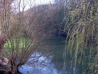
The Frome, historically the Froom, is a river that rises in Dodington Park, South Gloucestershire and flows southwesterly through Bristol to join the river Avon. It is approximately 20 miles (32 km) long, and the mean flow at Frenchay is 60 cubic feet per second (1.7 m3/s). The name Frome is shared with several other rivers in South West England and means 'fair, fine, brisk'. The river is known locally in east Bristol as the Danny.

St Pauls is an inner suburb of Bristol, England, situated just northeast of the city centre and west of the M32. It is bounded by the A38, the B4051, the A4032 and the A4044, although the River Frome was traditionally the eastern boundary before A4032 was constructed. St Pauls was laid out in the early 18th century as one of Bristol's first suburbs.

<span class="mw-page-title-main">Horfield, Bristol</span> Suburb of Bristol, England

Horfield is a suburb of the city of Bristol, in southwest England. It lies on Bristol's northern edge, its border with Filton marking part of the boundary between Bristol and South Gloucestershire. Bishopston lies directly to the south. Monks Park and Golden Hill are to the west. Lockleaze and Ashley Down are on the eastern fringe. The Gloucester Road (A38) runs north–south through the suburb.

<span class="mw-page-title-main">Easton, Bristol</span> Human settlement in England

Easton is an inner city area of the city of Bristol in the United Kingdom. Informally the area is considered to stretch east of Bristol city centre and the M32 motorway, centred on Lawrence Hill. Its southern and eastern borders are less defined, merging into St Philip's Marsh and Eastville. The area includes the Lawrence Hill and Barton Hill estates.

<span class="mw-page-title-main">Redland, Bristol</span> Human settlement in England

Redland is a neighbourhood in Bristol, England. The neighbourhood is situated between Clifton, Cotham, Bishopston and Westbury Park. The boundaries of the district are not precisely defined, but are generally taken to be Whiteladies Road in the west, the Severn Beach railway line in the south and Cranbrook Road in the east.

<span class="mw-page-title-main">Eastville, Bristol</span> Human settlement in England

Eastville is the name of both a council ward in the city of Bristol in the United Kingdom and a suburb of the city that lies within that ward. The Eastville ward covers the areas of Eastville, Crofts End, Stapleton and part of Fishponds. Notable places within the ward include Bristol Metropolitan Academy and Collegiate School, and the Bristol and Bath Railway Path also passes through the ward.

<span class="mw-page-title-main">Diocese of Bristol</span> Diocese of the Church of England

<span class="mw-page-title-main">Parks of Bristol</span>

The English city of Bristol has a number of parks and public open spaces.

<span class="mw-page-title-main">Montpelier railway station</span> Railway station in Bristol, England

Montpelier railway station is on the Severn Beach Line and serves the district of Montpelier in Bristol, England. It is 2.85 miles (4.59 km) from Bristol Temple Meads. Its three letter station code is MTP. The station has a single platform, serving trains in both directions. As of 2015 it is managed by Great Western Railway, which is the third franchise to be responsible for the station since privatisation in 1997. They provide all train services at the station, mainly a train every 30 minutes in each direction.

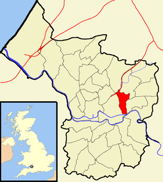
The city of Bristol, England, is divided into many areas, which often overlap or have non-fixed borders. These include Parliamentary constituencies, council wards and unofficial neighbourhoods. There are no civil parishes in Bristol.

Bristol is a city in south west England, near the Bristol Channel coast, approximately 106 miles (170 km) west of London. Several factors have influenced the development of its transport network. It is a major centre of employment, retail, culture and higher education, has many historic areas, and has a history of maritime industry. The city has a population of 450,000, with a metropolitan area of 650,000, and lies at the centre of the former County of Avon, which includes many dormitory towns, and has a population of one million.

<span class="mw-page-title-main">St Jude's, Bristol</span> Human settlement in England

St Jude's is a mixed residential, commercial and light industrial area of central Bristol, England. St Jude's forms part of the Lawrence Hill ward of Bristol City Council.

<span class="mw-page-title-main">Stapleton Road</span> Major thoroughfare in Bristol, England

Stapleton Road is a major thoroughfare in the English city of Bristol, running through the districts of Lawrence Hill and Easton. It is known for being very culturally diverse with many esoteric shops. However since the mid 20th century it has gained a reputation for having a high crime rate.

<span class="mw-page-title-main">20th century road schemes in Bristol</span>

Road building was central to planning policy for much of the 20th century in Bristol, England. The planned road network evolved over time but at its core was a network of concentric ring roads and high-capacity radial roads.

References

  1. "Ashley" (PDF). 2011 Census Ward Information Sheet. Retrieved 26 February 2015.
  2. Bristol City Council. "Ashley ward map" (PDF). Retrieved 31 October 2007.
  3. Bristol City Council. "Ashley ward census" (PDF). Retrieved 24 June 2017.
  4. "Vocalise". Vocalise. Retrieved 2 September 2017.
  5. "The Brass Industry". Living Easton. Retrieved 31 October 2007.
  6. "Baptist Mills Pottery". Living Easton. Retrieved 31 October 2007.
  7. Bristol City Council: Parks and open spaces: St Andrews Park Archived 27 September 2007 at the Wayback Machine
  8. Bristol City Council. "Ashley ward census" (PDF). Retrieved 24 June 2017.