
Ledsham is a village and civil parish 4 miles (6 km) north of Castleford and 11 miles (18 km) east of Leeds in the county of West Yorkshire, England. The village is in the City of Leeds metropolitan borough and near to the A1 Great North Road. It has a population of 162, increasing to 181 at the 2011 Census.

High Hoyland is a village and civil parish in the Metropolitan Borough of Barnsley in South Yorkshire, England, on the border with West Yorkshire. It lies to the west of Kexbrough, and is located at approximately 53°35′10″N1°35′30″W, at an elevation of around 200 metres above sea level. At the 2001 census it had a population of 142, reducing to 128 at the 2011 Census.

Beeley is a village and civil parish in northern Derbyshire, England. Located near Bakewell in the Derbyshire Dales, it is situated on the B6012 road, between Rowsley and Edensor. The civil parish population at the 2011 Census was 195.

Holme Valley is a large civil parish in the Metropolitan Borough of Kirklees in West Yorkshire, England. It has a population of 25,049, increasing to 34,680 for the two wards in the 2011 Census. Its administrative centre is in Holmfirth. Other sizeable settlements in the parish include, Brockholes, Honley and New Mill. It is named from the River Holme that runs through the parish.

Quarnford is a village and civil parish in the Staffordshire Moorlands district of Staffordshire, England. According to the 2001 census it had a population of 244, reducing marginally to 242 at the 2011 census. The village is in the Peak District, between Buxton and Leek.
Hartington Upper Quarter is a civil parish in the High Peak district of Derbyshire, England. The civil parish was created following the division of the ancient parish of Hartington into four. The parish had a population of 451 according to the 2001 census reducing to 438 at the 2011 Census.

Aston is a village and civil parish in the East Hertfordshire district of Hertfordshire, England. According to the 2001 census it had a population of 844, increasing to 871 at the 2011 Census. Located on a ridge between Stevenage and the Beane Valley, Aston is 10 minutes drive from the A1(M).
Aston juxta Mondrum is a village and civil parish in the unitary authority of Cheshire East and the ceremonial county of Cheshire, England. It is about four miles north of Nantwich. The civil parish also includes part of Worleston village.

Aston Eyre is a hamlet and civil parish in Shropshire, England, about four miles west of Bridgnorth. The area has a significant amount of green space. The spine road that runs through the centre of the village is the B4368.
Ravenstone with Snibston is a civil parish in the North West Leicestershire district of Leicestershire, England. According to the 2001 census it had a population of 2,149, increasing to 2,212 at the 2011 census. The parish includes Ravenstone, part of Snibston and the hamlet of Sinope. The parish was created in 1884.

Brough and Shatton is a civil parish in Hope Valley in the High Peak district of Derbyshire, England. It is named for the two hamlets of Brough-on-Noe and Shatton. Brough is about 2 km, or just over 1 mile, west (upstream) of Shatton; both are on the River Noe, a tributary of the upper River Derwent. They lie within the Peak District National Park, about 15 miles west of Sheffield and 30 miles east of Manchester. According to the 2011 census, Brough and Shatton had a combined population of 136. There is a friendly rivalry between the two hamlets, which contest numerous sports competitions throughout the year.
Flagg is a small Peak District village and civil parish, set in the Derbyshire Dales, halfway between the small market town of Bakewell and the spa town of Buxton, in the area officially known as "The White Peak". 1000 feet above sea level, Flagg is recorded in the Domesday Book as "Flagun", and is believed to have originally been a Viking settlement engaged primarily in lead mining, the evidence of which can still be seen today with many spoil heaps and disused mine shafts in the area. The population of the civil parish as taken at the 2011 Census was 192.
Kirklington is an affluent village and civil parish in the English county of Nottinghamshire.

Wormhill is a village and civil parish in the High Peak district of Derbyshire, England, situated east by north of Buxton. The population of the civil parish including Peak Dale was 1,020 at the 2011 Census.

Chidlow is a civil parish in the Cheshire West and Chester district and ceremonial county of Cheshire in England. In 2001 it had a population of 8.

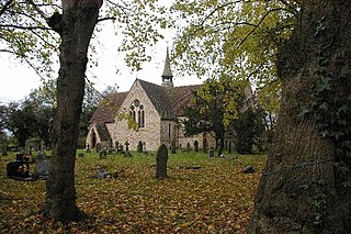
Stanton in Peak is a village in the Derbyshire Dales district of Derbyshire, It is about seven miles north-west of Matlock, on the north side of Stanton Moor, from Birchover. The name of the civil parish is Stanton with a population taken at the 2011 census of 365. There is a fine 19th century Parish Church, and many fine stone houses, with mullion windows. There is also a stately home, Stanton Park, a combination of the English Classical style, and later Palladian alterations, which is a private house.
Ellingham Harbridge and Ibsley is a civil parish in the west of the English county of Hampshire. The population of the civil parish at the 2011 Census was 1,171.

Edlington with Wispington is a civil parish in the East Lindsey district of Lincolnshire, England. It is situated approximately 2 miles (3 km) north-west from the town of Horncastle.
Idridgehay is a village in the English county of Derbyshire.
Greetham with Somersby is a civil parish in the East Lindsey district of Lincolnshire, England. It is situated approximately 3 miles (5 km) north-east from the market town of Horncastle.

