
Ucayali is an inland department and region of Peru. Located in the Amazon rainforest, its name is derived from the Ucayali River. Its capital is the city of Pucallpa. It is the second largest department in Peru, after Loreto, and it is slightly larger than South Korea.

Huntington Beach State Park is a 2500 acre coastal preserve and state park near Murrells Inlet, in Georgetown County, South Carolina. It has a large sandy beach, few beach-goers, and numerous wild birds to watch over the seasons.

Atalaya is the largest of four provinces in the Ucayali Region, in the central Amazon rainforest of Peru.
Lieutenant General Gerardo Pérez Pinedo Airport is a small regional airport serving the town of Atalaya, in the Ucayali Region of Peru. The town is at the confluence of the Tambo and Ucayali Rivers.

Atalaya del Cañavate is a municipality in Cuenca, Castile-La Mancha, Spain. It had a population of 98 as of 2020.
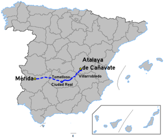
The Autovía A-43 is an autovía in south-central Spain.

Atalaya Castle, is correctly and historically known simply as Atalaya, and was the winter home of industrialist and philanthropist Archer M. Huntington and his wife, the sculptor Anna Hyatt Huntington, located in Huntington Beach State Park near the Atlantic coast in Murrells Inlet, Georgetown County, South Carolina.

Atalaya is a genus of eighteen species of trees and shrubs of the plant family Sapindaceae. As of 2013 fourteen species grow naturally in Australia and in neighbouring New Guinea only one endemic species is known to science. Three species are known growing naturally in southern Africa, including two species endemic to South Africa and one species in South Africa, Eswatini and Mozambique.
Atalaya is a corregimiento in Atalaya District, Veraguas Province, Panama with a population of 4,924 as of 2010. It is the seat of Atalaya District. Its population as of 1990 was 5,737; its population as of 2000 was 4,449.
Saint-Michel-de-l'Attalaye is a commune in the Marmelade Arrondissement, in the Artibonite department of Haiti. It has 95,216 inhabitants. It is the second largest city geographically after Port-au-Prince, the national capital. Located in the Central Plateau, it is home to several large Christian churches including one which has been there for over 50 years. It is a scenic locale, surrounded by rich farmland, abundant water resources and distant mountain peaks in every direction. There are excellent schools which are privately funded and a current (2011) small residential development outside of the main town area which is near completion which was originally sponsored by the central government. There is a new joint venture nearing completion with a Taiwanese partner that plans to bring bamboo crafts and goods manufacturing skills training to the local people.

Atalaya District is a district (distrito) of Veraguas Province in Panama. The population according to the 2000 census was 8,916; the latest official estimate ia 11,321. The district covers a total area of 156 km². The capital lies at the town of Atalaya.

Corta Atalaya is the largest open-pit mine in Europe and was at one time the largest in the world. It is located within the city limits of Minas de Riotinto in the province of Huelva, autonomous community of Andalusia, Spain. It is roughly elliptical in shape, 1,200 metres (3,900 ft) long, 900 metres (3,000 ft) wide, and 350 metres (1,150 ft) deep. It was one of the most ambitious projects of the Rio Tinto Group. At its peak it employed 2,000 workers mining copper; it was actively mined until 1992. Since at least 1994 it has been flooded up to the 16th ring.

La Atalaya is a municipality located in the province of Salamanca, Castile and León, Spain. As of 2016 the municipality has a population of 120 inhabitants.

European route E 903 is a European B class road in Spain, connecting the city Mérida – Alicante.

Atalaya is a ward (barrio) of Madrid belonging to the district of Ciudad Lineal.

The Towers of the churches of San Salvador and Santa Cruz were the towers of the destroyed churches of San Salvador and Santa Cruz located in Madrid.
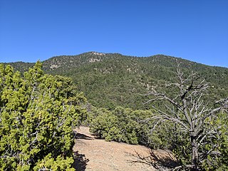
Atalaya Mountain is a mountain peak located within the Santa Fe National Forest, in northern New Mexico, United States. It is part of the Santa Fe Mountains in the Sangre de Cristo Range, a subrange of the Southern Rocky Mountains. A relevant viewscape from the city of Santa Fe, there are no higher peaks between the city and Atalaya Mountain to the east. Viewed from the city, Atalaya Mountain is framed by Sun Mountain to the right (south), Picacho Peak to the left (north), and Thompson Peak behind it. Atalaya Mountain is accessible by following the Atalaya Trail, or via the Dale Ball Trails from the direction of Picacho Peak and trail marker number 36.
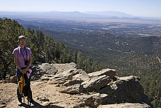
The Atalaya Trail is an out and back trail to the summit of Atalaya Mountain, in Santa Fe, New Mexico.
