
Calleva Atrebatum was originally an Iron Age settlement, capital of the Atrebates tribe, and subsequently a town in the Roman province of Britannia. Its ruins lie to the west of, and partly beneath, the Church of St Mary the Virgin, Silchester, in the county of Hampshire. The church occupies a site just within the ancient walls of Calleva, although the village of Silchester itself now lies about a mile to the west.
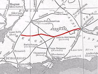
The Roman road from Silchester to Bath connected Calleva Atrebatum (Silchester) with Aquae Sulis (Bath) via Spinae (Speen), Cunetio and Verlucio. The road was a significant route for east-west travel and military logistics in southeast England during the 1st to 5th centuries.

Silchester is a village and civil parish about 5 miles (8 km) north of Basingstoke in Hampshire. It is adjacent to the county boundary with Berkshire and about 9 miles (14 km) south-west of Reading.

Reading Museum is a museum of the history of the town of Reading, in the English county of Berkshire, and the surrounding area. It is accommodated within Reading Town Hall, and contains galleries describing the history of Reading and its related industries, a gallery of artefacts discovered during the excavations of Calleva Atrebatum, a copy of the Bayeux Tapestry, finds relating to Reading Abbey and an art collection.

Epaticcus or Epaticcu was a brother of Cunobelinus, king of the Catuvellauni, a tribe of Iron Age Britain.

Beech Hill is a village and civil parish in Berkshire, England. It is in the south east of the West Berkshire district and bounds Hampshire and Wokingham district. The Foudry Brook, a tributary of the Kennet, and the Reading–Basingstoke railway line, run through the north of the parish.
The year 1909 in archaeology involved some significant events.

The A340 is a major road in the south of England, portions of which are known as the Aldermaston Road, Tadley Hill, Basingstoke Road and Tidmarsh Road.

Astolat is a legendary city of Great Britain named in Arthurian legends. It is the home of Elaine, "the lily maid of Astolat", and of her father Sir Bernard and her brothers Lavaine and Tirre.

Iping is a village and parish in the Chichester district of West Sussex, England. It lies within the civil parish of Stedham with Iping, just off the A272 road 2 miles (3.2 km) west of Midhurst. The village lies on the River Rother.

Staines Bridge is a road bridge running in a south-west to north-east direction across the River Thames in Surrey. It is on the modern A308 road and links the boroughs of Spelthorne and Runnymede at Staines-upon-Thames and Egham Hythe.
The decade of the 1780s in archaeology involved some significant events.
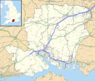
Aldermaston Soke is a hamlet that lies on the county boundary between Berkshire and Hampshire, and is administratively part of the civil parish of Mortimer West End, which was transferred from Berkshire to Hampshire in 1879.

Mortimer West End is a village and civil parish in north Hampshire in England. It lies in the northernmost point of the county.

Estaires is a commune in the Nord department of the Hauts-de-France region in northern France.

Lambourn Woodlands is a small village in the English county of Berkshire.

Woodlands St Mary is a small village in the English county of Berkshire.
Camlet Way was a Roman road in England which ran roughly east–west between Colchester (Camalodunum) in Essex and Silchester in Hampshire via St Albans (Verulamium). Camlet Way crossed the River Thames by bridge at Hedsor Wharf to Sashes Island near Cookham in Berkshire.

The Frith is a small univallate Iron Age hillfort to the north of Silchester, Calleva Atrebatum, Roman town. A single bank covers all sides apart from the south east, and is at the most about 5 feet (1.5 m) high on the western edge. A ditch is also traceable for the length of the bank, although at varying states.
The Devil's Highway was a Roman road in Britain connecting Londinium (London) to Pontes (Staines) and then Calleva Atrebatum (Silchester). The road was the principal route to the west of Britain during the Roman period but was replaced by other routes after the demise of Roman Britain. The bridges at Pontes probably crossed Church Island. At Calleva, the road split into three routes continuing west: the Port Way to Sorviodunum, Ermin Way to Glevum (Gloucester), and the road to Aquae Sulis (Bath). Its name probably derives from later ignorance of its origin and history, having been replaced for travellers by other roads nearby such as Nine Mile Ride, which runs parallel to the Roman road about a mile away but at a lower height.
This page is based on this
Wikipedia article Text is available under the
CC BY-SA 4.0 license; additional terms may apply.
Images, videos and audio are available under their respective licenses.
