Autostrada A10 (Italy)

Last updated
Autostrada A10 Italia.svg
Autostrada A10
Autostrada dei Fiori
Italia - mappa autostrada A10.svg
Route information
Part of Tabliczka E25.svg E25 Tabliczka E74.svg E74 Tabliczka E80.svg E80
Maintained by ANAS
Length158.1 km (98.2 mi)
Existed1967–present
Major junctions
From Genoa
To Ventimiglia
Location
Country Italy
Regions Liguria
Highway system
  • Roads in Italy

The Autostrada A10, also known as the Autostrada dei Fiori or the AutoFiori ("fiori" meaning "flowers" in Italian), is an Italian motorway, passing through Liguria and connecting Genoa with Ventimiglia. It connects to the French A8 autoroute, which finishes in Aix-en-Provence, and forms part of European route E80. It is 158.7 kilometres (98.6 mi) long. [1]

Contents

History

The route from Genoa to Savona was opened on 5 September 1967, [2] and the route from Savona to Ventimiglia was opened on 6 November 1971.

Between Genoa and Savona, the highway has been improved three times in recent times: the northern route, in the direction of Ventimiglia, has been renovated, while the opposite direction, towards Genoa, is now the original road, which formerly consisted of both directions. Accordingly, this side is of lower quality than the other; the widening of the road to three lanes has necessitated the removal of the emergency lane, and a reduction of all lanes to less than 3.75 m (12.3 ft) - this is less than the regulations of the Italian highway code, and has in turn caused a reduction of the speed limit to 80 km/h (50 mph) for most of the section between Albisola and Genoa Voltri.

The route between Savona and the Italian border, on the other hand, is completely new, having been built in the sixties; it consists of two carriageways side by side, with two lanes in each direction. It has, however, no emergency lane, but includes several places in which it is suitable to make an emergency stop.

On 14 August 2018, a section of the Ponte Morandi bridge that formed part of the A10 collapsed during a storm, killing 43 people. [3]

The Autostrada today

The route is currently run by two companies: from Genoa to Savona, by the company Autostrade Italy SpA, and from Savona to the border by Autostrada dei Fiori SpA. It has 22 entrances, and includes eight service stations.

Much of the route is built on hillside, with a series of viaducts and tunnels; for this reason, the entire motorway requires paying a toll charge (one of the most expensive in Italy). Past Savona, the motorway visits Albenga, Imperia, San Remo, and Ventimiglia: six kilometres from Ventimiglia, it reaches the border with France. Until the nineties, the border was marked by a change of stripe colour, from yellow to white, alongside a sign in the tunnel indicating the precise location of the border—this is now gone, although its former location can still be discerned from a change of lighting systems, and the different thicknesses of asphalt.

In the opposite direction, the A10 intersects with the A6, towards Turin, the A26, towards the Po Valley, Switzerland, and other major cities in the north of Italy, before finally joining the A7, towards Milan and Tuscany.

The highway has 78 tunnels between Genoa and Nice.

Route

A10 GENOA - VENTIMIGLIA
Autostrada dei Fiori
TypeIndication↓km↓↑km↑ProvinceEuropean road
AB-Kreuz-grun.svg Italian traffic signs - strada europea 64.svg Autostrada A7 Italia.svg Milan
Italian traffic signs - strada europea 80.svg Autostrada A12 Italia.svg Livorno
Italian traffic signs - strada europea 25.svg Italian traffic signs - icona traghetto.svg Genova Sampierdarena
0158,1 Genoa
AB-AS-grun.svg Genoa Airport 2156 Italian traffic signs - strada europea 80.svg Italian traffic signs - strada europea 25.svg
AB-AS-grun.svg Genoa Pegli 6152
AB-AS-grun.svg Genoa Pra' [4] 11147
AB-Kreuz-grun.svg Italian traffic signs - strada europea 25.svg Autostrada A26 Italia.svg Alessandria - Gravellona Toce 13145 Italian traffic signs - strada europea 80.svg
Zeichen 314 - Parkplatz, StVO 2013.svg South Terrarossa carpark140,3
AB-AS-grun.svg Arenzano 20138
AB-Tank.svg Service station "Piani d'Invrea"26132 Savona
AB-AS-grun.svg Varazze 27131
AB-AS-grun.svg Celle Ligure 32126
AB-AS-grun.svg Albisola 36120
AB-Tank.svg Service station "S.Cristoforo"42116
AB-AS-grun.svg Complanare Savona
AB-Kreuz-grun.svg Italian traffic signs - strada europea 717.svg Autostrada A6 Italia.svg Turin
AB-AS-grun.svg Savona
Italian traffic signs - icona rifornimento.svg "Aurelia Sud" service area
44113
AB-Tank.svg "Valleggia Nord" service station
AB-AS-grun.svg Spotorno 52106
AB-Tank.svg "Borsana Sud" service station
Zeichen 314 - Parkplatz, StVO 2013.svg "Borsana Nord" carpark55,7
Zeichen 314 - Parkplatz, StVO 2013.svg "Feglino Sud" carpark100
AB-AS-grun.svg Feglino [5] 6099
Zeichen 314 - Parkplatz, StVO 2013.svg "Aquila Sud" carpark98,7
AB-AS-grun.svg Finale Ligure 6395
AB-AS-grun.svg Pietra Ligure 6890
AB-AS-grun.svg Borghetto Santo Spirito 7286
Zeichen 314 - Parkplatz, StVO 2013.svg "Piccaro Nord" carpark75,5
AB-Tank.svg "Ceriale" service station7781
AB-AS-grun.svg Albenga 8177
AB-AS-grun.svg Andora 9365
AB-Tank.svg "Rinovo" service station95
Zeichen 314 - Parkplatz, StVO 2013.svg "Valle Chiappa" service station98.1
AB-Tank.svg "Valle Chiappa" service station60
AB-AS-grun.svg San Bartolomeo al Mare 10458 Imperia
Zeichen 314 - Parkplatz, StVO 2013.svg "Gorleri Est" carpark54,2
AB-AS-grun.svg East Imperia 11252
AB-AS-grun.svg West Imperia 11946
AB-Tank.svg "Conioli" service station38
AB-Tank.svg "Castellaro" service station123
AB-AS-grun.svg Arma di Taggia 12830
AB-AS-grun.svg Sanremo 13619
AB-Tank.svg "Bordighera" service station14315
AB-AS-grun.svg Bordighera 14612
AB-AS-grun.svg Ventimiglia Italian traffic signs - stazione.svg [6]
Italian traffic signs - strada europea 74.svg Strada Statale 20 Italia.svg Col de Tende - Cuneo
Italian traffic signs - icona rifornimento.svg "Autoporto" service station
151,86 Italian traffic signs - strada europea 80.svg Italian traffic signs - strada europea 74.svg
Italian traffic signs - stazione.svg Ventimiglia border post151,86
Autoroute F.svg Italian traffic signs - strada europea 74.svg Italian traffic signs - strada europea 80.svg Autoroute francaise 8.svg Menton - Monaco - Nice
Flag of France.svg National border: France
158,10

Related Research Articles

<span class="mw-page-title-main">Sanremo</span> City in Liguria, Italy

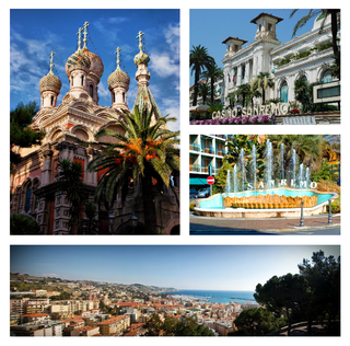
Sanremo or San Remo is a city and comune on the Mediterranean coast of Liguria, in northwestern Italy. Founded in Roman times, it has a population of 55,000, and is known as a tourist destination on the Italian Riviera. It hosts numerous cultural events, such as the Sanremo Music Festival and the Milan–San Remo cycling classic.

<span class="mw-page-title-main">Dual carriageway</span> Type of road

A dual carriageway (BrE) or a divided highway (AmE) is a class of highway with carriageways for traffic travelling in opposite directions separated by a central reservation (BrE) or median (AmE). Roads with two or more carriageways which are designed to higher standards with controlled access are generally classed as motorways, freeways, etc., rather than dual carriageways.

<span class="mw-page-title-main">Autostrade of Italy</span> National Motorway System of Italy

The Autostrade are roads forming the Italian national system of motorways. The total length of the system is about 7,016 kilometres (4,360 mi), as of 30 July 2022. In North and Central Italy, the Autostrade mainly consists of tollways managed by Autostrade per l'Italia, a holding company controlled by Cassa Depositi e Prestiti. Other operators include ASTM, ATP, and Autostrade Lombarde in the north-west; Autostrada del Brennero, A4 Holding, Concessioni Autostradali Venete, and Autovie Venete in the north-east; Strada dei Parchi, SALT, SAT, and Autocisa in the center; and CAS in the south.

<span class="mw-page-title-main">Genoa Cristoforo Colombo Airport</span> Airport

Genoa Airport also named Christopher Columbus Airport, and commonly named Aeroporto di Genova-Sestri Ponente, after the city district where it is located, is an international airport built on an artificial peninsula, 4 NM west of Genoa, Italy.

Switzerland has a two-class highway system: motorways with separated roads for oncoming traffic and a standard maximal speed limit of 120 kilometres per hour (75 mph), and expressways often with oncoming traffic and a standard maximal speed limit of 100 kilometres per hour (62 mph).

<span class="mw-page-title-main">Autostrada A24 (Italy)</span>

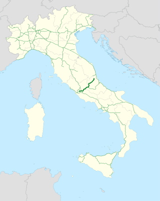
The Autostrada A24, or Autostrada dei Parchi, is a motorway connecting Rome to Teramo. Starting at the Grande Raccordo Anulare, the A24 runs broadly north-east past L'Aquila and through a 10 km tunnel under the Gran Sasso before reaching Teramo. Strada dei Parchi S.p.A. currently manages the route.

<span class="mw-page-title-main">Genoa–Ventimiglia railway</span>

The Genova-Ventimiglia railway runs along the coast of the Liguria region of Italy. It was opened as a single track line between Genova and Savona in 1868, and between Savona and Ventimiglia in 1872, mostly running along a coastal corniche.

<span class="mw-page-title-main">Autostrada A26 (Italy)</span>

The Autostrada A26 is a motorway in the northwestern Italian regions of Liguria and Piedmont. It is named the Autostrada dei Trafori after the numerous tunnels through which it passes, both Apennine and Subalpine. It runs northwards from Genoa on the Ligurian coast, over the Apennines, and across the wide plain of the Po valley to the environs of Lake Maggiore and the mouth of the Val d’Ossola. In addition to this ‘main trunk’ of the road, there are three side branches, also of motorway class which function as link roads between the A26 and the A7, the A4 and the A8. The A26, together with these link roads, is managed by Autostrade per l'Italia S.p.A.

<span class="mw-page-title-main">Autostrada A6 (Italy)</span>

The Autostrada A6 is an Italian motorway opened in 1960 which connects Turin, the southernmost area of Piedmont, especially the Cuneo province, to the west coast of Liguria and the city of Savona. Its construction finished in 2001, when it was completely overhauled into a two-road motorway

<span class="mw-page-title-main">Autostrada A15 (Italy)</span>

The A15 is an Italian autostrada (motorway) connecting Parma and La Spezia through the valleys of the Taro and Magra Rivers. The road is also known as Autostrada della Cisa because it crosses the Northern Apennines at the Cisa pass. The main 101-km expanse of the motorway connects the A1 with the A12, thus directly linking the Po Valley with the Italian Riviera and the Versilia region.

<span class="mw-page-title-main">Durrës-Kukës Highway</span> Toll motorway in Albania

The A1, also commonly Rruga e Kombit or SH10, is the longest and only toll motorway in Albania, stretching 114 kilometres (71 mi) in the counties of Lezhë and Kukës. It consists for the most part of two traffic lanes and an emergency lane in each driving direction separated by a central reservation.

This article describes the highway systems available in selected countries.

<span class="mw-page-title-main">Genova Sampierdarena railway station</span> Railway station in Genoa, Italy

Genova Sampierdarena railway station is located in Piazza Montano, in the Sampierdarena district of Genoa, Italy. It is Genoa's third most important railway station, after Genova Piazza Principe and Genova Brignole.

<span class="mw-page-title-main">Imperia</span> Comune in Liguria, Italy

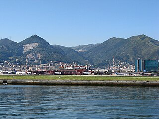
Imperia is a coastal city and comune in the region of Liguria, Italy. It is the capital of the Province of Imperia, and historically it was capital of the Intemelia district of Liguria. Benito Mussolini created the city of Imperia on 21 October 1923 by combining Porto Maurizio and Oneglia, as well as the surrounding village communes of Piani, Caramagna Ligure, Castelvecchio di Santa Maria Maggiore, Borgo Sant'Agata, Costa d'Oneglia, Poggi, Torrazza, Moltedo and Montegrazie.

<span class="mw-page-title-main">Autostrada A22 (Italy)</span>

The Autostrada A22 is one of the most important motorways in Italy, as it connects Pianura padana, the city of Modena and the A1 motorway to Austria through the Brenner Pass, located in the municipality of Brenner.

<span class="mw-page-title-main">A3 (Albania)</span> Motorway in Albania

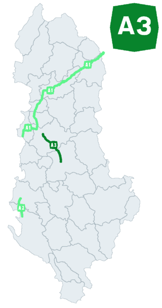
The A3 motorway is a motorway in Albania spanning 31.17 kilometres across the counties of Elbasan and Tirana. It consists of two traffic lanes and an emergency lane in each driving direction, except in tunnels where there are emergency bays instead, separated by a central reservation.

<span class="mw-page-title-main">Merula (creek)</span> Stream in Liguria, Italy

The Merula is a 14.7-kilometre (9.1 mi) stream of Liguria (Italy).

<span class="mw-page-title-main">Autostrada A34 (Italy)</span> Motorway in Italy

The Autostrada A34 is an Italian motorway that branches off of the A4 motorway at the Villesse junction going towards Gorizia. The motorway ends after 17 kilometers in Sant'Andrea / Vertoiba, where it continues as the H4 expressway in Slovenia. The highway is managed by Autovie Venete.

<span class="mw-page-title-main">Genoa-Saint George Bridge</span> Motorway viaduct in Genoa, Italy

The Genoa Saint George Bridge is a motorway viaduct that crosses the Polcevera river and the districts of Sampierdarena and Cornigliano, in the city of Genoa. It was designed by architect Renzo Piano.

References

  1. "Punti della strada A10: A10 Genova-Ventimiglia" . Retrieved 2017-07-14.
  2. Eugenio A. Merzagora (January 2016). "Motorways in Italy (numbering)".
  3. Crollo Genova, trovato l'ultimo disperso sotto le macerie: è l'operaio Mirko. Muore uno dei feriti, le vittime totali sono 43
  4. "Entrance of A10 Genova-Savona-Ventimiglia".
  5. Exit only westbound, entry only eastbound
  6. Open system of tolls to and from France.