Autostrada A3 (Italy)

Last updated

Autostrada A3 Italia.svg
Autostrada A3
Italia - mappa autostrada A3.svg
Route information
Part of E45
Maintained by ANAS
Length53.6 km (33.3 mi)
Existed1974 (old route)
2017 (current route)–present
Major junctions
From Naples
Major intersections Autostrada A1 Italia.svg A1 in Barra (Naples)
Autostrada A2dirNA Italia.png Spur route to Naples and Autostrada A2 del Mediterraneo - Italia.svg A2 in Salerno
To Salerno
Location
Country Italy
Regions Campania
Highway system
Autostrada A2 Italia.svg A 2 Autostrada A4 Italia.svg A 4

The Autostrada A3 is an autostrada (Italian for "motorway") in Southern Italy, which runs from Naples to Salerno, in the Campania region.

Contents

Until 2017 the route was much longer, going after Salerno further south until Reggio Calabria; on this year, this section became part of the new Autostrada A2 and of its two spur routes.

History

Naples-Pompeii motorway in the first half of the 20th century Autostrada Napoli-Pompei 1.jpg
Naples-Pompeii motorway in the first half of the 20th century
Naples-Pompeii motorway in the 1960s Autostrada Napoli-Pompei 5.jpg
Naples-Pompeii motorway in the 1960s

Due to sections not being originally constructed to anywhere near Motorway standard and to the notoriously poor conditions of maintenance, and also to the difficult terrain along some of the route, the motorway has been often taken as a symbol of the backwardness and economical problems of southern Italy. Italian historian Leandra D'Antone has defined it "a true Italian shame". [1] The European Union declines to classify the road as a "motorway" due to the decades-long roadwork restrictions on a supposedly modern road [2] and seeks recompense for its financial contributions. [3]

The first stretch of the road to be completed was the Naples-Pompeii section, finished on 22 June 1929. The connection onward to Salerno was completed on 16 July 1961. In 1964 the Italian government decided to build a motorway which connected the rest of Italy to Calabria, so far considered a kind of "Third Island" (together with Sicily and Sardinia), due to the nature of its terrain, which made it problematic to reach the region. The new motorway was built in a total of 8 years, the works being delivered on 13 June 1974.

The road built by 1974 was more similar to a sub-standard freeway (Italian: strada statale, "state road") than to the other autostrade (motorways) in Italy. [4] Hard shoulders were absent, curves were often sharp, and in many places merge lanes were absent - the cars entering the motorway instead had to wait at stop signs. By the 1990s the road was severely deteriorated. [5]

1997–2017 Renovation

Queues became a common feature, especially in summer. To solve the situation, the Italian government funded the construction of a new route which would remove the high gradients and sharp turns and enlarge the carriageway. This required the construction of new tunnels and viaducts (among these the viadotto italia the highest in Italy) while keeping the traffic on the current motorway open. The reconstruction works started in 1997 and officially ended in 2016 during a ceremony although works continued until late 2017. The EU antifraud investigation of works undertaken between 2007 and 2010 together with the repayment of over €300m to the EU in July 2012 have delayed completion of the upgrade works even further. [3] [6]

The cost of the upgrade (in August 2013) was projected to reach over €10bn by the time it was eventually completed, then envisaged as 2018. The section from Salerno to Reggio Calabria alone, 442 km long, would cost €10bn with the rest spent on widening/upgrades already completed between Naples and Salerno. €7.443 Bn had been spent up to 2011 on parts of the 442 km section between Salerno and Reggio Calabria. [7] [8]

On 22 December 2016 the Salerno-Reggio Calabria freeway was declared complete, 20 years after the first renovation works started, with the opening of Larìa tunnel in Cosenza. [9] In a ceremony held in Reggio Calabria, prime minister Paolo Gentiloni begged pardon "for the delay" [10] and the road name was changed from "A3 Salerno-to-Reggio Calabria" to "A2 Autostrada del Mediterraneo" (Highway of the Mediterranean).

Construction

The entire road was constructed as a substandard freeway [11] by the mid-1970s and later an upgrade program from Naples to Reggio Calabria started in the early 1990s. The section with three lanes in each direction has a length of 105 km, between Naples and RA02 which goes towards Potenza. The section from the interchange with the A1 motorway in Naples to the Pompeii exit, built during the 1920s, originated as a local turnpike, and was later retrofitted to motorway standard. Many of the junctions along the original A3 route completed in the 1970s had very tight corners and extremely limited deceleration fields; this is especially significant on the now more than 50-year-old Naples-Salerno section, where at some junctions there are stop-signs for traffic entering the motorway. [4] Hard shoulders only appeared along the route as part of the post 1990 upgrades, with only occasional emergency bays at infrequent locations on the sections that have not been upgraded yet.

The concession of the Northern part was owned by Autostrade Meridionali  [ it ], a company listing in Borsa Italiana and a subsidiary of Autostrade per l'Italia, which in turn a subsidiary of Atlantia. The southern segment (Salerno-Reggio Calabria) is toll-free and is maintained by ANAS, the state agency for public routes. Located in a mountainous area, it is prone to very high levels of traffic (especially at the start and at the end of holiday periods).

Upgrade progress

Starting in 1997 the motorway underwent heavy modernisation, in many cases a completely new parallel motorway was built alongside the original A3 and involved in most cases a complete rebuilding or replacement of the road where the alignment was retained. [12] By August 2014, works on 391 km of the road (88%) were completed. 16 more km of rebuilding/modernization was then due to be completed. [13] A number of new junctions were also to be constructed, in some cases to service certain towns with no direct access at present. [14] In May 2015 then prime minister Renzi indicated that the upgrade programme would be terminated by 2016. [15]

By March 2016 68 km remained to be done. Plans to upgrade 58 km were abandoned and changed from Motorway Construction projects to "Maintenance" [16] [17] Maintenance will involve pavement and structural renewal and is projected to cost €1bn between 2016 and 2021 instead of the €3bn that ANAS projected as the cost of fully upgrading the 3 remaining sections. [18] These total 58 km of the new length of 435 km from Salerno to Campo Calabro and do not include the final 10 km from Campo Calabro to Reggio Calabria which remains as constructed in the 1970s. Also abandoned were a number of planned junctions. [19] The motorway standard road will terminate at Campo Calabro approximately 10 km to the north of Reggio Calabria, and the remaining 10 km of old A3 into Reggio Calabria will not be upgraded to full motorway standards.

Major Cities

A3 goes through many cities, that are Salerno, Nocera Inferiore, Pompei, Torre Annunziata, Torre del Greco, Ercolano, Pompei, Portici, San Giorgio a Cremano, and Naples.

Route

Autostrada A3 near Torre Annunziata A3torre.PNG
Autostrada A3 near Torre Annunziata
Autostrada A3 viaduct near Salerno Salerno - viadotto Canalone.jpg
Autostrada A3 viaduct near Salerno
Autostrada A2 Italia.svg NAPLES – SALERNO
Exit↓km↓↑km↑ProvinceEuropean Route
Italian traffic signs - autostrada.svg Italian traffic signs - citta.svg Napoli Italian traffic signs - centro citta.svg - Via G. Ferraris
Italian traffic signs - icona stazione fs.svg Napoli Centrale railway station
0.053.6 NA  
AB-Vzw-grun.svg
Napoli Italian traffic signs - centro citta.svg - Via Nuova Marina
Italian traffic signs - icona porto.svg Port of Naples
2.051.6 NA  
AB-AS-grun.svg Napoli San Giovanni
Italian traffic signs - icona industria.svg Via Gianturco
Napoli Barra
2.551.1 NA  
AB-Vzw-grun.svg
Italian traffic signs - strada europea 45.svg Autostrada A1 Italia.svg Caserta - Roma
Italian traffic signs - strada europea 842.svg Autostrada A16 Italia.svg Avellino
Italian traffic signs - strada europea 55.svg Autostrada A14 Italia.svg Bari
Autostrada A56 Italia.svg Tangenziale di Napoli
Italian traffic signs - icona aeroporto.svg Naples Capodichino Airport
3.150.0 NA Tabliczka E45.svg E45
AB-AS-grun.svg Napoli Ponticelli - S.Giorgio Nord5.545.2 NA Tabliczka E45.svg E45
AB-AS-grun.svg San Giorgio a Cremano 6.445.2 NA Tabliczka E45.svg E45
AB-AS-grun.svg Portici 8.043.6 NA Tabliczka E45.svg E45
AB-AS-grun.svg Ercolano
Italian traffic signs - icona zona archeologica.svg Herculaneum
8.543.1 NA Tabliczka E45.svg E45
AB-AS-grun.svg Torre del Greco
Italian traffic signs - icona foresta.svg Vesuvius National Park
11,540.1 NA Tabliczka E45.svg E45
AB-AS-grun.svg Torre Annunziata Nord
Italian traffic signs - icona zona archeologica.svg Oplontis
15,036.6 NA Tabliczka E45.svg E45
AB-AS-grun.svg Torre Annunziata Sud20.031.6 NA Tabliczka E45.svg E45
AB-AS-grun.svg Pompei Ovest
Italian traffic signs - icona zona archeologica.svg Pompeii
21.929.7 NA Tabliczka E45.svg E45
AB-AS-grun.svg Castellammare di Stabia
Strada Statale 145 Italia.svg Sorrentina
Italian traffic signs - icona mare fiume lago.svg Sorrento Peninsula
Sorrento - Agerola - Vico Equense
22.529.1 NA Tabliczka E45.svg E45
AB-AS-grun.svg Scafati -Pompei centro 25.026.6 NA Tabliczka E45.svg E45
AB-AS-grun.svg Diramazione Strada Statale 268 Italia.svg del Vesuvio
Angri - Sant'Antonio Abate - Scafati
28.223.3 SA Tabliczka E45.svg E45
AB-AS-grun.svg Angri
Italian traffic signs - icona mare fiume lago.svg Amalfi Coast - Ravello
29.721.9 SA Tabliczka E45.svg E45
AB-AS-grun.svg Nocera Inferiore
Strada Statale 18 Italia.svg Tirrena Inferiore
Italian traffic signs - icona zona archeologica.svg Nuceria Alfaterna
36.615.0 SA Tabliczka E45.svg E45
AB-Tank.svg AB-Rast.svg Rest area "Alfaterna"39.911.5 SA Tabliczka E45.svg E45
AB-AS-grun.svg Cava de' Tirreni 42.98.7 SA Tabliczka E45.svg E45
AB-AS-grun.svg Vietri sul Mare 48.43.2 SA Tabliczka E45.svg E45
Italian traffic signs - autostrada.svg Italian traffic signs - strada europea 45.svg Autostrada A2 Italia.svg Salerno - Reggio Calabria
Autostrada A2dirNA Italia.svg.png Italian traffic signs - strada europea 45.svg Spur route to Napoli
51.60.0 SA Tabliczka E45.svg E45

See also

Other Italian roads

Related Research Articles

<span class="mw-page-title-main">Transport in Italy</span> Overview of the transport in Italy

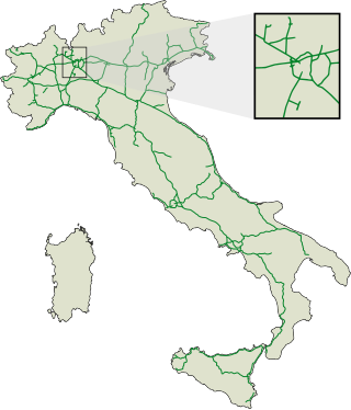
Italy has a well developed transport infrastructure. The Italian rail network is extensive, especially in the north, and it includes a high-speed rail network that joins the major cities of Italy from Naples through northern cities such as Milan and Turin. The Florence–Rome high-speed railway was the first high-speed line opened in Europe when more than half of it opened in 1977. Italy has 2,507 people and 12.46 km2 per kilometer of rail track, giving Italy the world's 13th largest rail network. The Italian rail network is operated by state-owned Ferrovie dello Stato, while the rail tracks and infrastructure are managed by Rete Ferroviaria Italiana.

<span class="mw-page-title-main">Strait of Messina Bridge</span> Proposed suspension bridge linking Sicily to mainland Italy

The Strait of Messina Bridge is a planned 3.6-kilometre suspension bridge across the Strait of Messina, connecting Torre Faro in Sicily with Villa San Giovanni in the Italian Peninsula.

<span class="mw-page-title-main">Autostrade of Italy</span> National motorway system of Italy

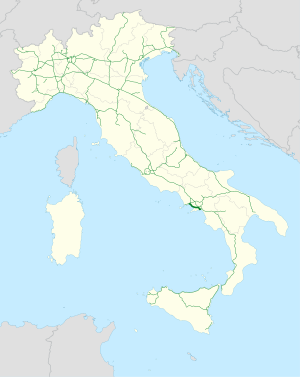
The autostrade are roads forming the Italian national system of motorways. The total length of the system is about 7,016 kilometres (4,360 mi), as of 30 July 2022. To these data are added 13 motorway spur routes, which extend for 355 kilometres (221 mi).

<span class="mw-page-title-main">High-speed rail in Italy</span> Overview of the high-speed rail system in Italy

High-speed rail in Italy consists of two lines connecting most of the country's major cities. The first line connects Turin to Salerno via Milan, Bologna, Florence, Rome and Naples, the second runs from Turin to Venice via Milan and Verona, and is under construction in parts. Trains are operated with a top speed of 300 km/h (190 mph).

<span class="mw-page-title-main">Autostrada A1 (Italy)</span> Motorway in Italy

The Autostrada A1, nicknamed Autostrada del Sole, is the longest autostrada in Italy, linking some of the largest cities of the country: Milan, Bologna, Florence, Rome and Naples. It is a part of the E35 and E45 European routes.

<span class="mw-page-title-main">Autostrada A26 (Italy)</span>

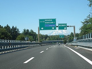
The Autostrada A26 is a motorway in the northwestern Italian regions of Liguria and Piedmont. It is named the Autostrada dei Trafori after the numerous tunnels through which it passes, both Apennine and Subalpine. It runs northwards from Genoa on the Ligurian coast, over the Apennines, and across the wide plain of the Po valley to the environs of Lake Maggiore and the mouth of the Val d’Ossola. In addition to this ‘main trunk’ of the road, there are three side branches, also of motorway class which function as link roads between the A26 and the A7, the A4 and the A8. The A26, together with these link roads, is managed by Autostrade per l'Italia S.p.A.

<span class="mw-page-title-main">Autostrada A2 (Italy)</span>

Autostrada A2, otherwise known as the Autostrada del Mediterraneo or Salerno–Reggio Calabria, is an autostrada long 432 kilometres (268 mi) in the south of Italy. Running between the towns of Fisciano, in the Province of Salerno, and Villa San Giovanni, in the Province of Reggio Calabria, the motorway forms part of European roads E45, E841 and E90.

<span class="mw-page-title-main">Autostrada A4 (Italy)</span> Motorway which connects Turin and Trieste via Milan and Venice

The Autostrada A4, or Autostrada Serenissima, is an autostrada which connects Turin and Trieste via Milan and Venice. The city of Venice originally formed a bottleneck on the A4, but is now bypassed by the Passante di Mestre. The A4 passes just north of the city of Milan, where it is toll-free.

<span class="mw-page-title-main">Autostrada A91 (Italy)</span>

The Autostrada A91, also called Autostrada Roma-Fiumicino, is an Italian motorway which connects Rome to the Fiumicino Airport.

<span class="mw-page-title-main">Adriatic–Ionian motorway</span> Future road in Europe

Adriatic–Ionian motorway or Trieste-Kalamata Highway or the Blue Corridor, is a future motorway that will stretch along the entire eastern shore of the Adriatic and Ionian seas, spanning the western coast of the Balkan peninsula from Italy in the north through Slovenia, Croatia, Montenegro, Albania to Greece in the south.

<span class="mw-page-title-main">State highways (Italy)</span> State highway system of Italy

The Strade Statali, abbreviated SS, is the Italian national network of state highways. The total length for the network is about 25,000 km (16,000 mi).

<span class="mw-page-title-main">A3 (Albania)</span> Motorway in Albania

The A3 motorway is a motorway in Albania spanning 31.17 kilometres across the counties of Elbasan and Tirana. It consists of two traffic lanes and an emergency lane in each driving direction, except in tunnels where there are emergency bays instead, separated by a central reservation.

<span class="mw-page-title-main">Roads in Italy</span> Overview of the various types of roads in Italy

Roads in Italy are an important mode of transport in Italy. The classification of the roads of Italy is regulated by the Italian traffic code, both from a technical and administrative point of view. The street nomenclature largely reflects the administrative classification. Italy is one of the countries with the most vehicles per capita, with 690 per 1000 people in 2010.

<span class="mw-page-title-main">Autostrada A30 (Italy)</span>

The Autostrada A30 is an Italian motorway which connects Caserta to Salerno.

<span class="mw-page-title-main">Salerno–Reggio di Calabria railway</span> Key southern Italian transport link

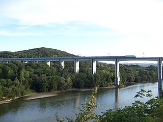
The Salerno–Reggio Calabria railway is the most important north–south railway connection between Sicily, Calabria and the rest of the Italian peninsula. It forms the southern section of Corridor 1 of the European Union's Trans-European high-speed rail network, which connects Berlin and Palermo. Its southern part, between Rosarno and San Lucido is also used as an RFI freight route between the Port of Gioia Tauro and the Adriatic railway.

<span class="mw-page-title-main">Strada statale 18 Tirrena Inferiore</span> Highway in southern Italy

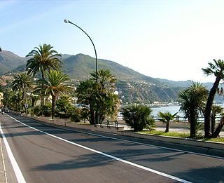
The strada statale 18 "Tirrena Inferiore" is an Italian state road, connecting Campania and Calabria. It is among the longest and most important state highways in southern Italy, considering that it follows the Tyrrhenian coast, from Salerno to Reggio di Calabria.

<span class="mw-page-title-main">Raccordo autostradale RA4</span>

Raccordo autostradale RA4 is a motorway that connects the Autostrada A2 with Strada statale 106 Jonica through the city of Reggio Calabria. The motorway junction also constitutes the central section of the so-called Reggio Calabria ring road.

<span class="mw-page-title-main">Raccordo autostradale RA6</span>

Raccordo autostradale 6 , managed by ANAS, is a motorway in Central Italy and allows a quick connection of the SS 3 bis near the city of Perugia with the Autostrada del Sole where the route begins in the locality of Bettolle, municipality of Sinalunga (SI). The RA 6 is a seamless continuation of the Strada statale 715 Siena-Bettolle and, on the other end, it continues as SS 75 up to Foligno.

References

  1. (in Italian)...una vera e propria «vergogna italiana», in La storia della Salerno Reggio Calabria Archived 22 July 2011 at the Wayback Machine , book about Salerno-Reggio Calabria
  2. Organised crime may be behind problems with southern motorway: Awkward questions remain about Italian infrastructure, in
  3. 1 2 Nadeau, Barbie Latza (7 July 2012). "The Mafia-Built Highway That Could Cost Italy $471 Million". The Daily Beast.
  4. 1 2 (in Italian)l'autostrada, completamente statale e senza pedaggio, con le sue due corsie, somiglia più ad una strada statale Salerno-Reggio Calabria: L’autostrada che non c'è Archived 27 February 2011 at the Wayback Machine , La Soria siamo noi, Rai Educational, in which the A3 is defined "the most devastated motorway stretch in Italy".
  5. Tofalo, Markus. "Autostrada IT-A3, 1994". Selica Media – Markus Tofalo (in German). Retrieved 23 April 2024.
  6. "Italy Repays €307m to EU after Road Project Mafia Corruption" . Retrieved 22 April 2024.
  7. "Anas S.p.A. - Attività dell'Anas sulla Salerno - Reggio Calabria" (in Italian). Archived from the original on 29 September 2011. Retrieved 21 August 2011. Stradaneanas Works Update (in Italian)
  8. (in Italian) repubblica.it Around €10bn projected for Salerno = Reggio upgrade 6 March 2011 (in Italian)
  9. "Salerno-to-Reggio Calabria complete". ANSA. 22 December 2016.
  10. "Da oggi A2, l'Autostrada del Mediterraneo. Gentiloni: "Scusate per il ritardo"". calabriapage.it (in Italian).
  11. Photos and videos of the Salerno-Reggio Calabria "scandal" at A3 Salerno-Reggio Calabria:uno Scandalo! Archived 3 April 2010 at the Wayback Machine , radicalweb.org, 23 January 2010
  12. (in Italian) Salerno Reggio Calabria ed il General Contractor unico Archived 22 July 2011 at the Wayback Machine , Le strade, May 2007
  13. (in Italian) ANAS Update Summer 2014 Archived 29 September 2011 at the Wayback Machine
  14. "Pietro Ciucci ANAS CEO Speech in Brussels 14 November 2012 (English)". Archived from the original on 24 May 2015. Retrieved 10 August 2013.
  15. "Prime Minister announces completion A3 by 2016, here is the current situation/Premier annuncia completamento A3 entro 2016, ecco la situazione attuale". La Metino. 18 May 2015. Retrieved 30 December 2016.
  16. "A3 Upgrade History". Stradeanas. Retrieved 19 March 2016.
  17. "'Maintenance' Plan Infographic March 2016 ( Italian)" (PDF). Stradeanas. Archived from the original (PDF) on 19 March 2016.
  18. "Sa-Rc, only maintenance for the last 58 km/Sa-Rc, solo manutenzione per gli ultimi 58 chilometri". Il Sole 24. Il Sole 24. 11 March 2016. Retrieved 30 December 2016.
  19. "Prime Minister announces completion A3 by 2016, here is the current situation". La Metino. 18 May 2015. Retrieved 30 December 2016.